


Thawing may be a welcome sight for Alaskans following a remarkably cold winter and early spring in much of the state. But with melting comes the threat of rapid flooding in low-lying areas as river ice breaks up and periodically jams.
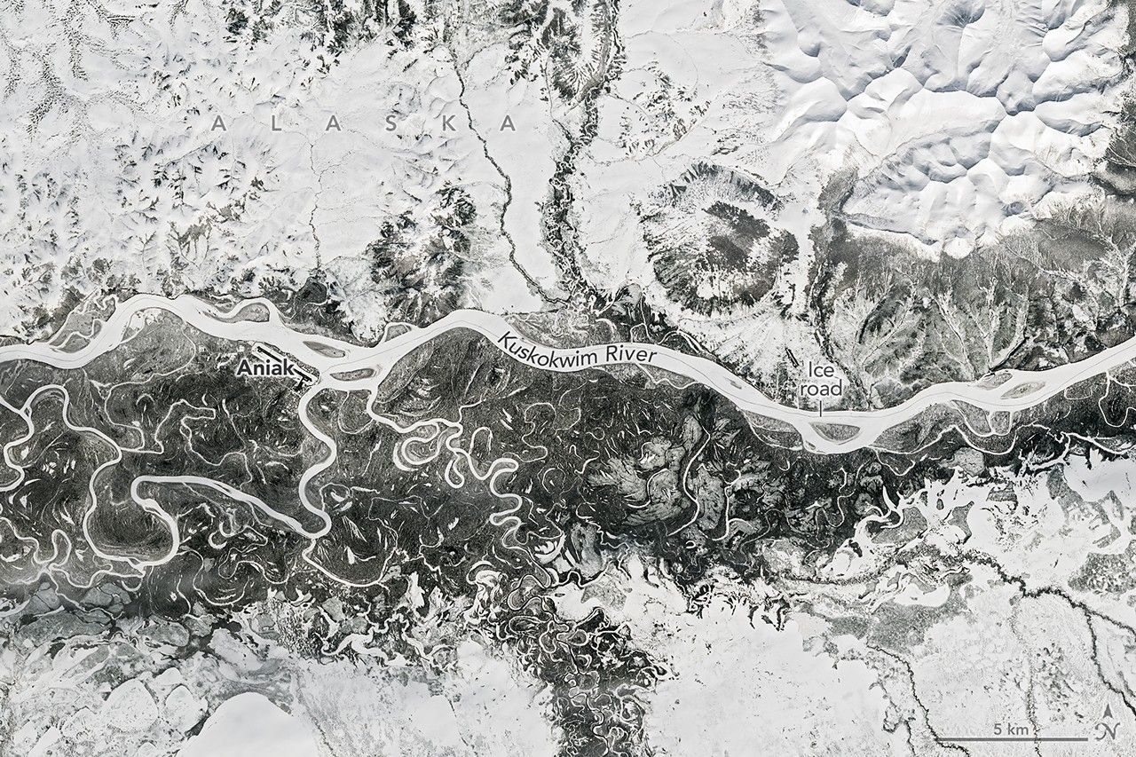
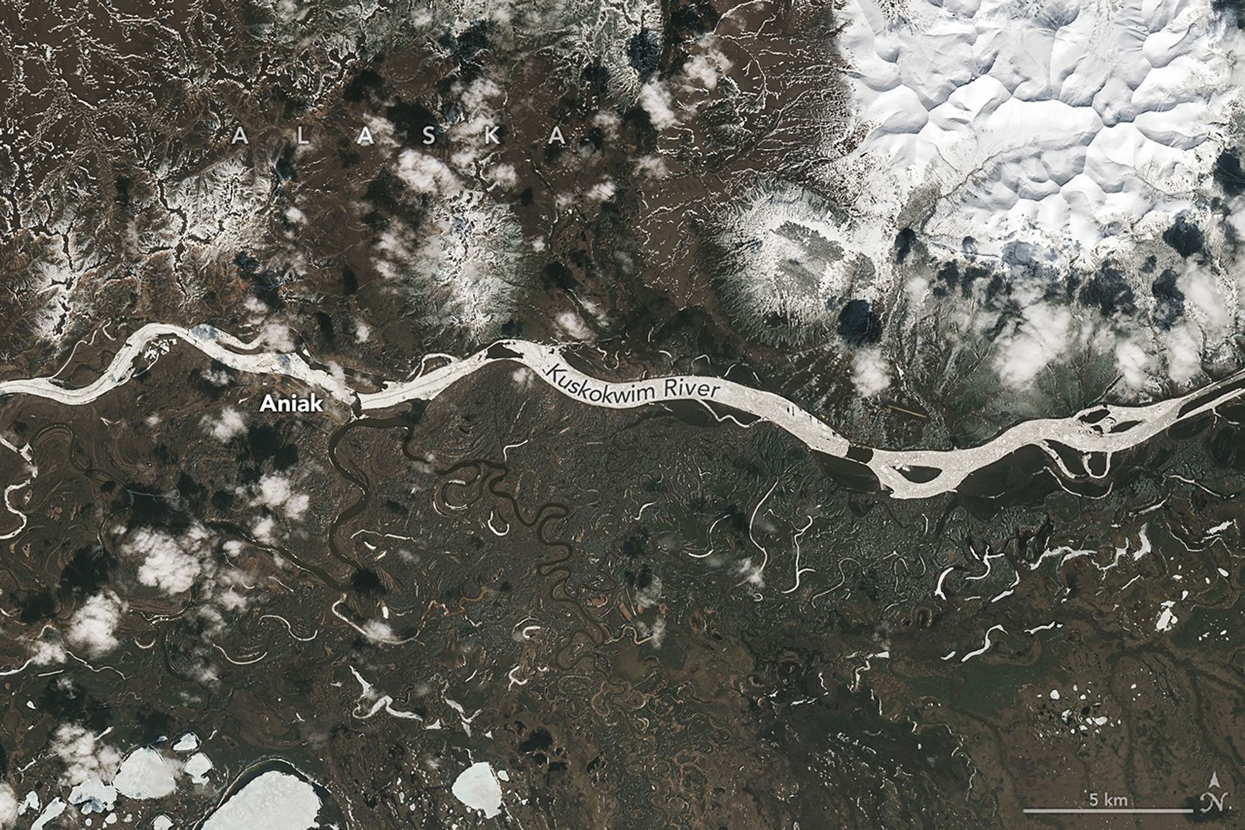
The landscape along the Kuskokwim River appeared frozen in a Landsat 9 image acquired on April 21, 2026 (left). According to observations published by the Alaska-Pacific River Forecast Center, river ice near the town of Aniak was thick and still covered in deep snow as of April 16. The Kuskokwim ice road connecting numerous villages traces a dark line down the river. The thick river ice supported a route that extended about 350 miles (560 kilometers) in winter 2025-2026 and shut down for the season on April 10, according to news reports.
Conditions were changing quickly around May 7, when the right image was acquired. The previous day, the front of the ice breakup had nearly reached Aniak, and a sheet of grounded ice caused a jam that stretched 21 miles (34 kilometers) upstream. News reports showed ice chunks several feet thick piled up on riverbanks around the town. Ice became unstuck by May 7, and the backup, visible above (right), had started to flow downstream.
Aniak remained at risk, however, as ice clogged the river later that night, this time several miles downstream from the community. Waters began to rise, and a flood watch was issued for the town on May 8. Water inundated low-lying areas and encroached on homes and businesses near the east side of the runway, according to reports, before receding two days later.
Flooding caused by spring breakup can be most hazardous when heavy snowpack and thick ice remain in place from the winter and there’s a sudden transition from freezing to warmer temperatures. In what is known as a dynamic breakup, snowmelt encounters intact ice and causes water to back up quickly. On the other hand, if ice weakens before significant snowmelt or ice from upstream arrives, jams are less likely to form.
Forecasters noted that spring 2026 showed warning signs of a dynamic breakup. Snowpack was above average in some major river drainages, and historically low temperatures marked the winter and spring months in many places. For example, the March average temperature in Bethel, downstream of Aniak, was 14 degrees Fahrenheit (8 degrees Celsius) below normal. However, floods had been relatively minor along the large rivers through early May, experts noted, while cautioning that more severe flooding still has the potential to develop quickly.
NASA Earth Observatory images by Michala Garrison, using Landsat data from the U.S. Geological Survey. Story by Lindsey Doermann.


References & Resources
- Alaska and Arctic Climate Newsletter (2026, May 8) Spring 2026 River Break-up to May 8th. Accessed May 13, 2026.
- Alaska’s News Source (2026, May 9) Mother’s Day weekend: May weather action. Accessed May 13, 2026.
- Alaska’s News Source (2026, April 24) A projected late river breakup could lead to dangerous flooding potential in Alaska. Accessed May 13, 2026.
- Alaska-Pacific River Forecast Center (2026) River Notes. Accessed May 13, 2026.
- KYUK (2026, May 9) Thermal breakup on the Kuskokwim may bode well for many communities, while Aniak remains under flood warning. Accessed May 13, 2026.
- Lindsey, S. (2019) Spring breakup on the Yukon: What happens when the ice stops. Alaska Park Science, 18(1): 70-75.


