


Following intense monsoon rains, a landslide struck Zhouqu County of China’s Gansu Province on August 8, 2010. By early September, the death toll stood at 1,765, Dave’s Landslide Blog reported, and this single event contributed to an unusually high worldwide death toll for landslides in 2010.
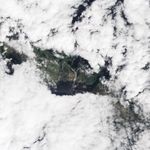
Weeks after the event, the landslide in remained visible to the Advanced Land Imager (ALI) on NASA’s Earth Observing-1 (EO-1) satellite. ALI captured this natural-color image on September 7, 2010. Bare earth forms a giant Y shape on the otherwise forested mountain slopes. The separate slides have coalesced into a wide river of mud flowing into town. Clouds leave part of the landscape in shadow, but the landslide remains discernible all the way to the river at the bottom of the valley.
References & Resources
- Petley., D. (2010, September 3). August fatal landslide data. Dave’s Landslide Blog. Accessed September 14, 2010.
NASA Earth Observatory image created by Jesse Allen and Robert Simmon, using EO-1 ALI data provided courtesy of the NASA EO-1 team. Caption by Michon Scott.