


Relentless rains, a dam failure, and open flood gates might have all played a role in devastating floods in Africa’s most populous nation at the end of September 2010. On September 28, Agence France-Presse reported that some 2 million people had been affected, and about 50,000 families had been left homeless in northern Nigeria.
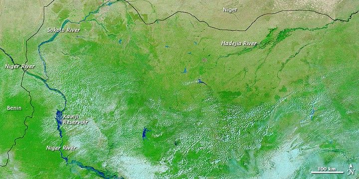
The Moderate Resolution Imaging Spectroradiometer (MODIS) on NASA’s Terra satellite captured these false-color images on October 16, 2009 (bottom) and October 8, 2010 (top), before and after floods swept through the region.
These images use a combination of infrared and visible light to increase the contrast between water and land. Water ranges in color from electric blue to navy. Clouds range from off-white to light blue-green. Vegetation is bright green. Bare ground appears in shades of pink-brown.
The Niger River, which flows into Nigeria from the northwest along the Benin-Niger border, appears substantially swollen in 2010, as does the Sokoto River that joins the Niger north of the Kainji Reservoir. The worst reports of damage, however, arose from the area around the Hadejia River in the northeast. According to news reports, a dam failure in the northern part of the country, combined with the decision to open flood gates on two other dams, sent floodwaters across croplands, pasturelands, and settlements. Besides displacing residents, the flooding destroyed crops, adding to worries about food security. The Associated Press reported that crops in the northern part of the country play a major role in feeding the commerce-driven south.
References & Resources
- Agence France-Presse. (2010, September 26). Agency denies opened dams caused Nigeria floods. Accessed October 8, 2010.
- BBC. (2010, September 24). Northern Nigeria flooding “displaces two million.” Accessed October 8, 2010.
- Gambrell, J. (2010, September 28). Flooding in Nigeria worsens food shortage. Associated Press. Accessed October 8, 2010.
- Njanji. S. (2010, September 28). Flood victims sleep by roadsides in northern Nigeria. Agence France-Presse. Accessed October 8, 2010.
- United Nations Environment Programme. (2008). Africa: Atlas of Our Changing Environment. Division of Early Warning and Assessment, United Nations Environment Programme, Nairobi, Kenya.
NASA images courtesy MODIS Rapid Response Team at NASA GSFC. Caption by Michon Scott.


