


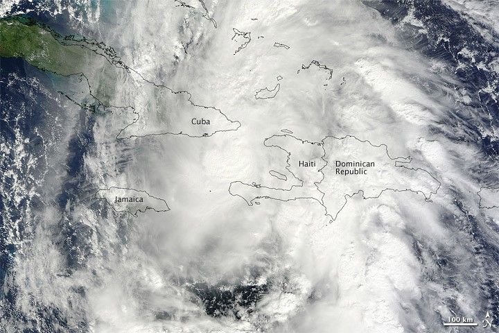
Tomas strengthened and weakened multiple times after forming on October 29, 2010. The storm initially headed westward, parallel to the northern coastline of South America, before turning sharply to the north and passing between Cuba and Haiti. At 2:00 p.m. Eastern Daylight Time (EDT) on November 5, 2010, the U.S. National Hurricane Center (NHC) reported that Tomas was a Category One hurricane, with maximum sustained winds of about 85 miles (140 kilometers) per hour. Tomas was located roughly 75 miles (120 kilometers) southeast of Guantanamo, Cuba, and about 140 miles (230 kilometers) northwest of Port-au-Prince, Haiti.
At 11:30 a.m. EDT (15:30 UTC) on November 5, 2010, the Moderate Resolution Imaging Spectroradiometer (MODIS) on NASA’s Terra satellite captured this natural-color image of Tomas, hovering between Cuba and Haiti. Although the storm lacks a distinct eye, it sports the apostrophe shape typical of tropical cyclones.
The NHC reported that Tomas was heading toward the north-northeast at about 12 miles (19 kilometers) per hour. The storm was expected to continue in that direction, picking up speed over the next 24 to 36 hours. A hurricane warning was in effect for Haiti, the southeastern Bahamas, the Turks and Caicos Islands, and the Cuban province of Guantanamo.
The arrival of Hurricane Tomas posed additional risks to the residents of Haiti, still coping with long-term effects of a devastating earthquake that struck in January 2010.
References & Resources
- International Telecommunication Union. (2010, November 5). ITU deploys satellite communications to prepare for hurricane in Haiti. ReliefWeb. Accessed November 5, 2010.
- National Hurricane Center. (2010, November 5). Hurricane Tomas Advisory Archive. Accessed November 5, 2010.
- Unisys Weather. (2010, November 5). Hurricane Tomas. Accessed November 5, 2010.
NASA image by Jeff Schmaltz, MODIS Rapid Response Team at NASA GSFC. Caption by Michon Scott.


