

- MPG-1 (.mpg) format (1.61 Mb)
- Quicktime (.mov) format (845 kb)
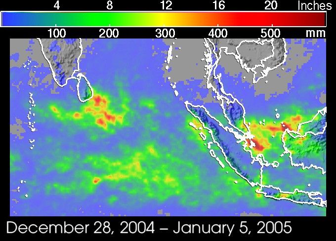
The cleanup and relief efforts from the recent tsunamis continue in coastalcommunities that were ravaged by the waves all across the Indian Ocean. Heavyrains have further complicated the matter and added to the misery in parts ofeastern Sri Lanka. Between December 28, 2004, and January 5, 2005, up to 10 to 15 inches of rain may have fallen along the southeast coast of the island, and as much as 20 inches (red areas) fell just offshore. This rainfall map was created by the TRMM-based, near-real time Multi-satellite PrecipitationAnalysis (MPA) at the NASA Goddard Space Flight Center, which monitors rainfall overthe global tropics. The map shows that many other regions around the Indian Ocean were also affected by the rains, including Malaysia and parts of Sumatra.
The heaviest rains fell on December 31 and January 4. The rains were likely theresult of a combination of the northeast monsoon interacting with the topographyand an active phase of what is known as the Madden-Julian Oscillation (MJO)(or 30-60 day oscillation). The MJO is a large-scale disturbance that propagateseastward from the Indian Ocean into the West Pacific Ocean, bringing extendedperiods of unsettled weather with it. Individual convective complexes withinthe MJO can last on the order of a day.
TRMM is a joint mission between NASA and the Japanese space agency JAXA.
References & Resources
NASA image produced by Hal Pierce (SSAI/NASA GSFC) and caption by Steve Lang (SSAI/NASA GSFC).