


The 2011 Atlantic hurricane season has been busy so far in terms of tropical storms with seven named storms; however, none of them havehad a very large impact. Each has been small, short-lived orremained at sea, and none have intensified into a hurricane untilIrene reached hurricane status on August 22.
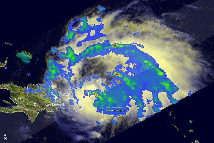
The Tropical Rainfall Measuring Mission (TRMM) satellite passeddirectly over Irene as the storm moved westward toward the Dominican Republic from Puerto Rico. The images were taken at 15:57 UTC (11:57 AM EDT) on August 22, 2011.
The top image shows a top-down view of the rain intensity within the storm. TRMM reveals that although a hurricane, Irene has not yet developed an eye and is not yet fully organized. The center of the storm is located just to the southwest of an area of heavy rain (shown in red) about midway between Puerto Rico and the Dominican Republic. Rainbands, containing light to moderate rain (shown in blue and green, respectively) curve around the storm mainly to the north and east of the center, revealing the presence of the storm’s low pressure circulation, but one that is not yet intense.
Rain rates in the center of the swath arefrom the TRMM Precipitation Radar and those in the outer swathare from the TRMM Microwave Imager. The rain rates are overlaidon infrared data from the TRMM Visible Infrared Scanner.
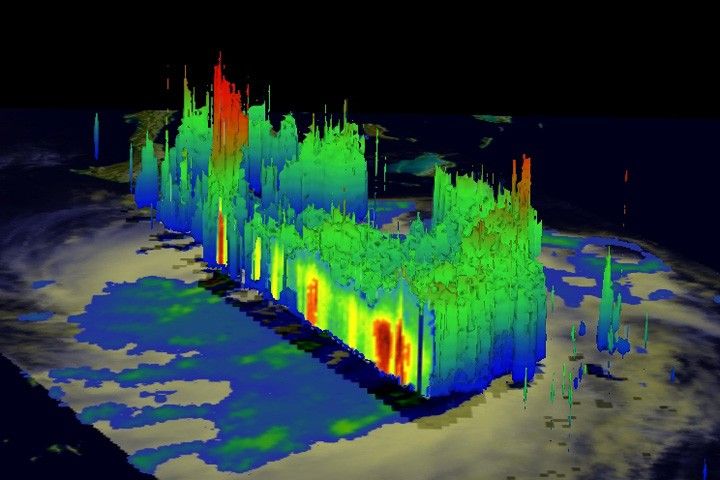
The lower image, taken at the same time, provides a three dimensionalperspective the storm. It reveals an area of deep convection (shown inred) near the storm’s center where precipitation-sized particles arebeing carried aloft. These tall towers are associated with strongthunderstorms responsible for the area of intense rain near the centerof Irene seen in the previous image. They can be a precursor tostrengthening as they indicate areas within a storm where vast amountsof heat are being released. This heating, known as latent heating, iswhat is drives a storm’s circulation and intensification.At the time these images were taken, Irene was a Category 1 hurricane withmaximum sustained winds reported at 70 knots (about 130 kilometers per hour or 80 miles per hour) by the NationalHurricane Center. Irene is expected to turn to the northwest towards thecentral Bahamas and intensify where it could become a major hurricane.
Irene, which originated from a tropical wave that propagated offthe west coast of Africa, became the 8th named storm of the season asit approached the Lesser Antilles on August 20 and the firsthurricane of the season as it was passing over Puerto Rico on themorning of the 22nd. Now back over open water, Irene is poised to passclose to the northern coast of Hispaniola and poses a threat to theBahamas.
TRMM is a joint mission between NASA and the Japanese space agency JAXA.
References & Resources
Images produced by Hal Pierce and caption by Steve Lang and Hal Pierce.
None


