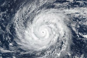
Hurricane Jimena moved slowly over Baja California on September 2, 2009, as the Moderate Resolution Imaging Spectroradiometer (MODIS) on NASA’s Aqua satellite captured this true-color image. Storm clouds extend from the Pacific Ocean across Baja California and the Gulf of California to central Mexico.
On September 2, 2009, the U.S. National Hurricane Center reported that Hurricane Jimena was a Category 2 hurricane with maximum sustained winds near 165 kilometers (105 miles) per hour and stronger gusts. The hurricane center predicted that the storm would weaken over the subsequent 24 hours, and by September 3, 2009, the center reported that sustained winds had decreased to 75 kilometers (45 miles) per hour. Despite slower winds, however, the storm dropped heavy rains as it came ashore.
References & Resources
NASA image by Jeff Schmaltz, MODIS Rapid Response Team, Goddard Space Flight Center. Caption by Michon Scott.

