


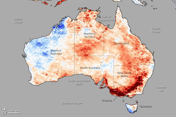
Deep red paints the coastal mountains of southeastern Australia, hangs over the continent’s arid interior, and dots much of the rest of the land in this image, indicating that unusually high temperatures reigned in November 2006. According to the Australian Bureau of Meteorology, the monthly average temperature for the country hit a record high in November. The average temperature for the continent was 2.11 degrees Celsius warmer than average, with local temperatures rising more than 4 degrees C above average for the month in places.
These abnormally high air temperatures are reflected in the extreme land surface temperatures shown in this image. The land is usually much warmer to the touch than the temperature recorded by a thermometer hanging above the ground, and so, during November, land surface temperatures in Australia were as much as 10 degrees Celsius above a five-year average. The greatest deviation from normal temperatures is shown in dark red in this image. Average temperatures are white, and cooler-than-average temperatures are blue. The temperature data were collected by the Moderate Resolution Imaging Spectroradiometer (MODIS) on NASA’s Terra satellite.
The temperature anomaly was greatest in the Great Dividing Range, which curves along the coasts of Victoria and New South Wales in southeast Australia. The heat and a lack of spring rain may have primed the mountains for devastating wildfires. By the end of December, several large wildfires raced through the mountains, threatening local communities and clouding the skies over much of southeastern Australia with dense smoke.
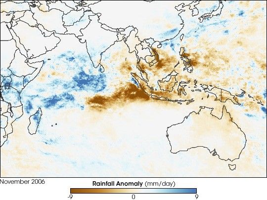
The high temperatures in the Great Dividing Range and elsewhere were just part of an unusually warm and dry spring, which in turn, was an extension of a dry year. Some of the dryness may be linked to a weak El Niñno in the Pacific Ocean. El Niñno is a regular climate pattern during which sea surface temperatures in the eastern Pacific Ocean near the equator heat up and trade winds weaken. Though the effects of El Niñno vary, the phenomenon often changes rainfall patterns around the world. In Australia, El Niñno often brings a dry winter and spring. It is also linked to an increase in the number of extreme fire days, during which conditions are hot, dry, and windy.
- Australian Monthly Climate Summary: November 2006 issued by the Australian Bureau of Meteorology.
- Australian Rainfall Patterns During El Nino Events issued by the Australian Bureau of Meteorology.
References & Resources
NASA image by Jesse Allen, based on data from Zhengming Wan, MODIS Land Surface Temperature Group, Institute for Computational Earth System Science , University of California, Santa Barbara.


