


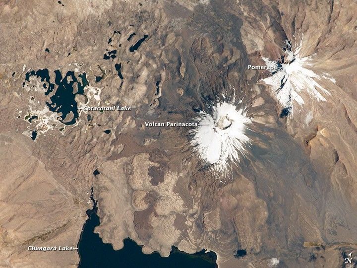
Volcan Parinacota (“flamingo lake” in the Aymara language) is a potentially active stratovolcano located on the Altiplano, a high plateau in the Andes mountains of west-central South America. While no direct observations of eruptive activity have been recorded, surface exposure dating of lava flows suggests that activity occurred as recently as 290 AD (± 300 years). Local Aymara stories also suggest that the volcano has erupted within the past 1000 years.
This astronaut photograph from the International Space Station highlights the symmetrical cone of Parinacota, with its well-developed summit crater (elevation 6,348 meters, or 20,827 feet, above sea level). Dark brown to dark gray surfaces to the east and west of the summit include lava flows, pyroclastic deposits, and ash.
A companion volcano, Pomerape, is located across a low saddle to the north. This volcano last erupted during the Pleistocene Epoch (approximately 3 million to 12,000 years ago). Together, Parinacota and Pomerape form the Nevados de Payachata volcanic area. The summits of both volcanoes are covered by white snowpack and small glaciers.
Eruptive activity at Parinacota has directly influenced development of the local landscape, beyond the placement of volcanic deposits. Approximately 8,000 years ago, the western flank of the volcano collapsed, creating a debris avalanche that traveled 22 kilometers (14 miles) to the west. The debris blocked rivers and streams, leading to the formation of Chungará Lake to the south (lower left). The uneven, hummocky surface of the avalanche debris provides ample catchments for water, as evidenced by the numerous small ponds and Cotacotani Lake to the west.
References & Resources
Astronaut photograph ISS029-E-20003 was acquired on October 7, 2011, with a Nikon D2Xs digital camera using a 400 mm lens, and is provided by the ISS Crew Earth Observations experiment and Image Science & Analysis Laboratory, Johnson Space Center. The image was taken by the Expedition 29 crew. The image has been cropped and enhanced to improve contrast. Lens artifacts have been removed. The International Space Station Program supports the laboratory as part of the ISS National Lab to help astronauts take pictures of Earth that will be of the greatest value to scientists and the public, and to make those images freely available on the Internet. Additional images taken by astronauts and cosmonauts can be viewed at the NASA/JSC Gateway to Astronaut Photography of Earth. Caption by William L. Stefanov, Jacobs/ESCG at NASA-JSC.


