


![Request for Information – Potential [Placeholder for Prize]](https://assets.science.nasa.gov/dynamicimage/assets/science/missions/a-step/FFR_Earth_Background_20251120%20.png?w=1024)


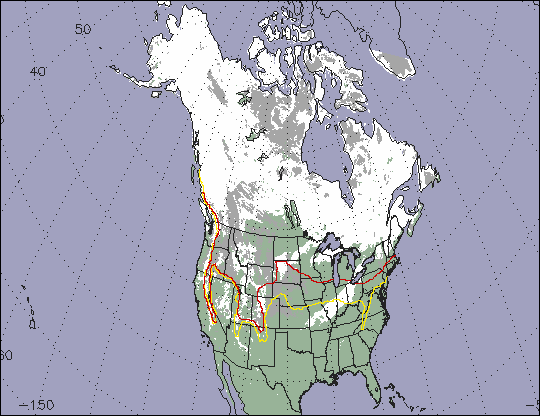
The winter of 1999/2000 brought relatively little snow cover to the North American continent. This MODIS eight-day composite map shows the maximum snow cover in North America during the period from March 5-12. When compared to the snow extent during average years, it is apparent that there was significantly less area covered by snow this year for each month from November through April.
In this image, the areas covered by snow are colored white, the non-snow covered land surface is colored green, those regions obstructed by clouds appear as grey, and water is blue. The red line represents the "average" March snowline, and the yellow line represents the "average" February snow line, as determined from NOAA/NESDIS snow maps (1966-present). Note that the snow line in March of 2000 is considerably farther north than the average February or Marchsnow lines.
By February, scientists reported that water levels in the Great Lakes--the world's largest inland bodies of fresh water--were much lower than normal. Lakes Michigan and Huron were 18 inches below average, and Lakes Superior and Erie were 9 inches below average. From 30 to 40 percent of these lakes' annual water supplycomes from melting snow, the lack of which is contributing to the lower water levels. A concern is that the paltry snowpacks of this past winter, combined with high evaporative rates this coming summer, could result in the lowest lake levels on record.
By the time these data were acquired, the snow line had retreated into southern Canada, but in the continental U.S., the Rocky Mountains, Cascades, Coast Range, and Sierra Nevada were still covered by snow, as were other isolated areas in the western states. Additionally, there was a band of snow spanning parts of Ohio, Indiana, Illinois, and Missouri. This band of snow was quite short-lived,lasting only a day or so, but was captured by MODIS because of its frequent coverage.
The smaller extent and earlier northward retreat of the snow cover during this past winter has led to an earlier drying of the soils in many areas, which has contributed to the large number of wildfires so far this year.
MODIS flies aboard the Terra spacecraft, launched in December 1999. The sensor first opened its doors and began acquiring data on Feb. 24, 2000. The MODIS sensor and Terra mission are managed by NASA's Goddard Space Flight Center.
References & Resources
Image data courtesy Dorothy Hall, Nick DiGirolamo, George Riggs, and Janet Chien - MODIS Land Science Team
None


