![Request for Information – Potential [Placeholder for Prize]](https://assets.science.nasa.gov/dynamicimage/assets/science/psd/solar/2023/09/s/solarsystem_0.jpg?w=1024)


In 2000, the Aral Sea was in grave condition. This inland sea, which was once Earth’s fourth-largest lake, had been steadily shrinking since the 1960s, when Soviet-era irrigation projects diverted the main rivers sustaining the sea. The lake shrunk to a quarter of its original size in a few decades, creating an environmental and public health disaster. As the lake dried up, winters became colder and harsher, and summers became hotter and more arid. Blowing dust, laden with pesticides and other chemicals, is routinely scoured from the dry lake bed and poses a severe public health hazard.
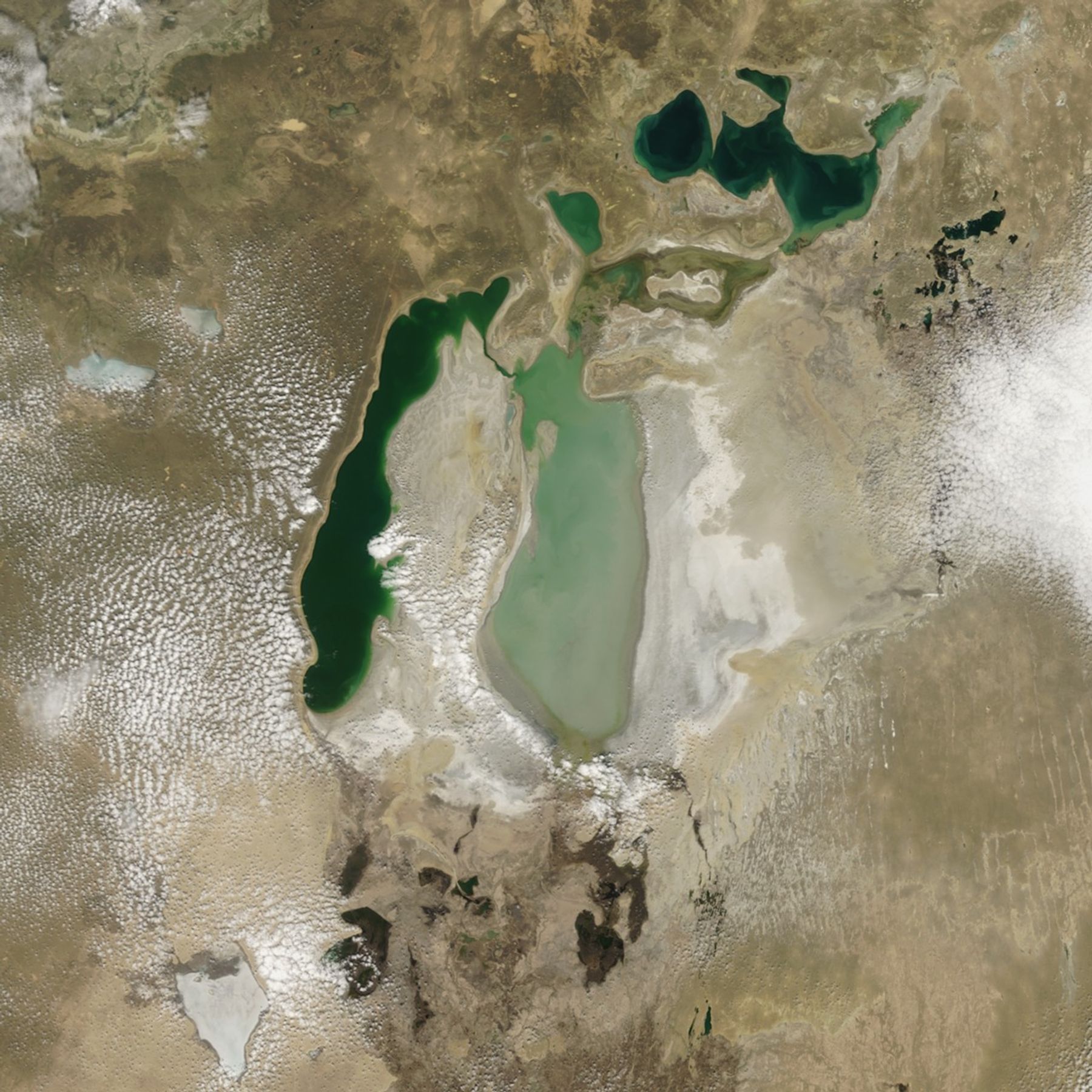
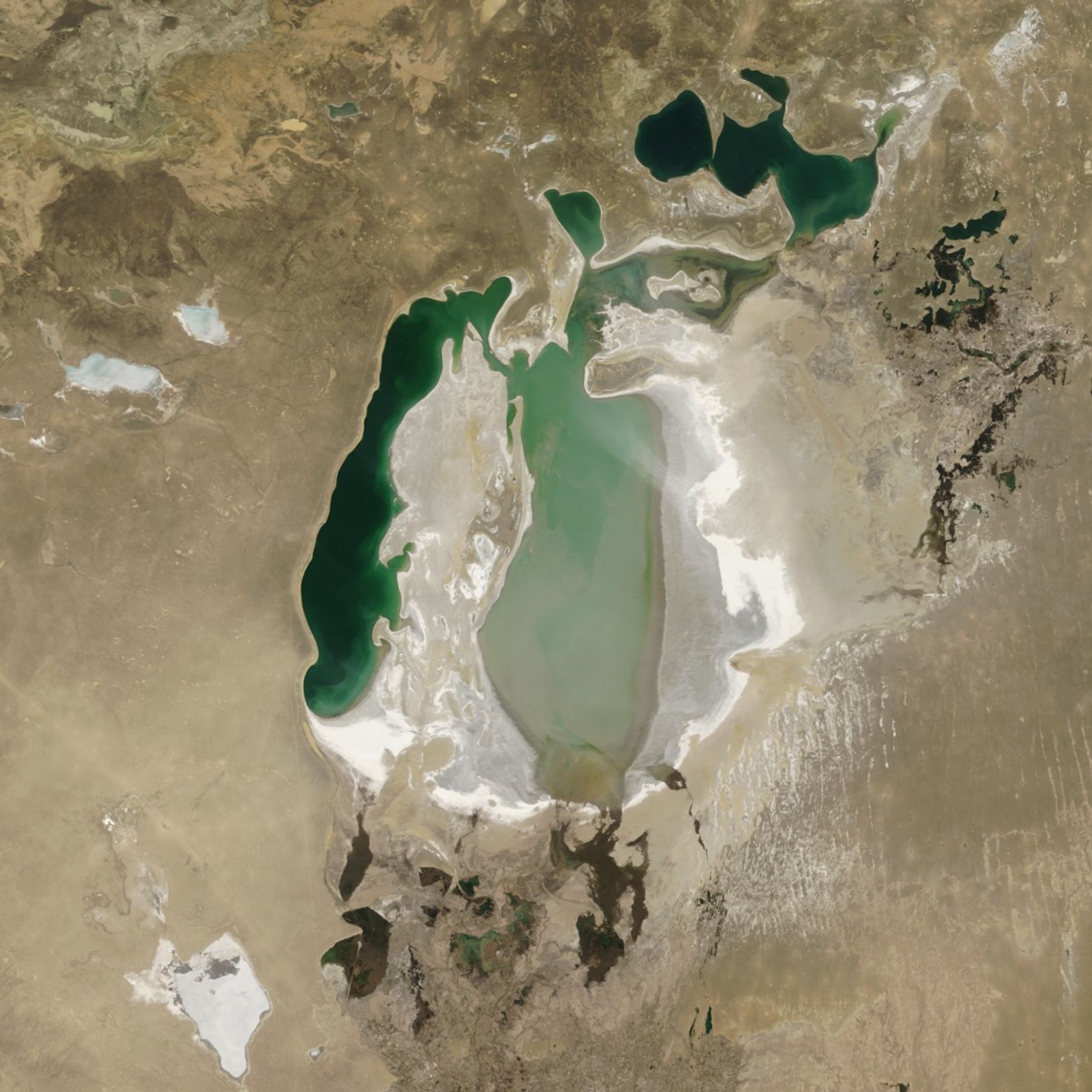
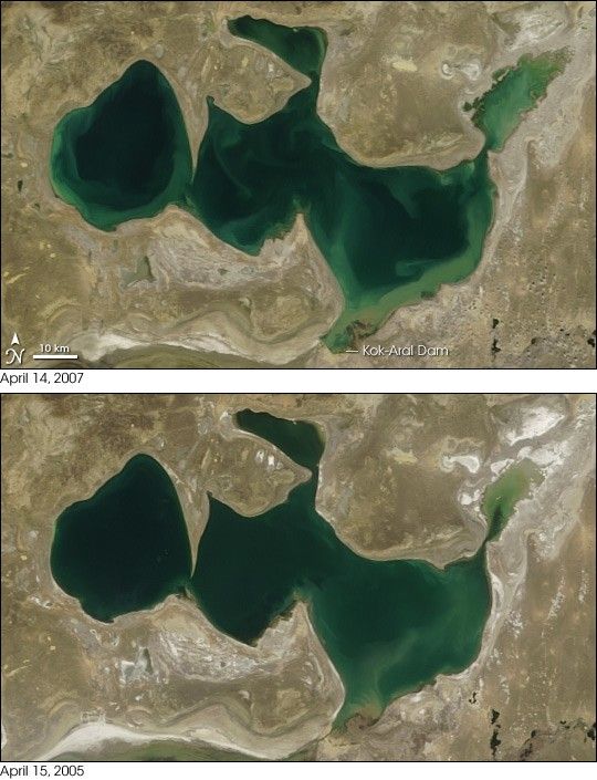
In 2007, however, the North Aral Sea was enjoying a renaissance, due the construction of a dam in 2005 that prevents water from flowing into the South Aral Sea. This pair of images acquired by the Moderate Resolution Imaging Spectroradiometer (MODIS) on NASA’s Terra satellite shows the recovery of the Aral Sea between April 15, 2005 (bottom), and April 14, 2007 (top). The recovery is most dramatic in the upper right part of the image, although a close look at the lake’s borders show a general rise in water level throughout the lake. Much of this recovery actually occurred in the first year after the dam was completed.
The North Aral Sea owes its rebirth to the Kok-Aral Dam, an $85.8 million project bolstered by a loan from the World Bank. The dam separates the North Aral Sea from its saltier and more polluted southern half. In early 2006, the Embassy of the Republic of Kazakhstan announced that the Aral Sea had shown dramatic recovery in just months, rather than the five to ten years originally predicted.
Local economies, long dependent on the water, were making a comeback as well. One example was Aralsk, the one-time port city that had gradually been surrounded by desert. By the spring of 2006, Aralsk was once again close to the water. On April 9, 2007, BBC News reported that the government of Kazakhstan had secured a new loan of $126 million from the World Bank to build a second dam, aimed at returning water to Heralsk, a former port that was deserted as the lake shrank.
You can download a 250-meter-resolution KMZ file of the Aral Sea for use with Google Earth.
References & Resources
NASA images created by Jesse Allen, using data provided courtesy of the MODIS Rapid Response Team at NASA GSFC.