













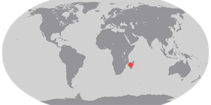

Multiple storms struck the region of Madagascar and the Mozambique Channel in early 2012: Tropical Depression Dando in mid-January, Tropical Cyclone Funso in late January, and Tropical Cyclone Giovanna in mid-February. At the end of February, a fourth storm came to life. Irina started as a tropical storm on February 29. By March 1, the U.S. Navy’s Joint Typhoon Warning Center (JTWC) reported, it was a tropical cyclone. Irina had maximum sustained winds of 55 knots (100 kilometers per hour) with gusts up to 70 knots (130 kilometers per hour).
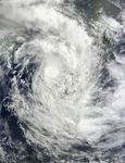
The Moderate Resolution Imaging Spectroradiometer (MODIS) on NASA’s Terra satellite captured this natural-color image on March 1, 2012. The storm appears to feature a coiled center surrounded by large spiral arms. Clouds cover most of Madagascar.
As of March 1, the JTWC reported, Irina was located roughly 185 nautical miles (345 kilometers) southwest of Antananarivo and was moving southward. The storm was forecast to take a more westward trajectory across the Mozambique Channel over the next couple of days.
References & Resources
- Joint Typhoon Warning Center. (2012, March 1). Tropical Cyclone 14S (Irina) Warning. Accessed March 1, 2012.
- Unisys Weather. (2012, March 1). Irina Tracking Information. Accessed March 1, 2012.
NASA image courtesy Jeff Schmaltz, LANCE/EOSDIS MODIS Rapid Response Team at NASA GSFC. Caption by Michon Scott.