


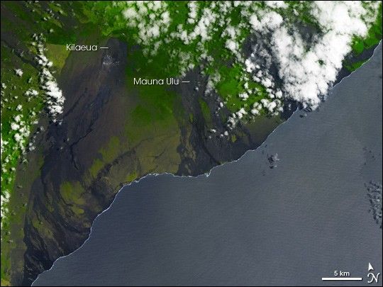
On June 17, 2007, the ground under Kilauea underwent a seismic swarm—a flurry of small earthquakes. A couple weeks later, on July 2, 2007, the Advanced Spaceborne Thermal Emission and Reflection Radiometer (ASTER) flying on NASA’s Terra satellite captured this image of Kilauea. In this simulated true-color image, brown indicates bare rock, green indicates vegetation, and white indicates clouds. Ocean water appears blue-gray.
This image shows the results of previous eruptive activity at Kilauea’s main crater and the Mauna Ulu crater on the volcano’s flank. A close look at the bare rock around the volcanoes reveals rivulets of rock, slightly darker than their surroundings, flowing from both craters toward the coast. In between areas of bare lava, vegetation has managed to thrive. Despite the hazards they pose, volcanoes provide fertile soil, one reason many people chose to live with the risk.
Kilauea is a shield volcano—a wide, flat volcano resembling a warrior shield composed mostly of hardened lava flows from earlier eruptions. This volcano overlaps another shield volcano, Mauna Loa. In historical times, Kilauea has been Hawaii’s most active volcano. In 1983, the volcano began a long-term eruption that both created and destroyed, incinerating homes while building coastline over the following decades.
Mauna Ulu is not the only crater on Kilauea’s flank. Another crater, Pu’u O᾿o, came to life not long after this picture was taken. On July 21, 2007, lava erupted from that crater, for the first time since February 1992. Tropical Storm Cosme hampered investigations in the early hours of the eruption, but when crews were able to examine the crater, they found eruptive activity along a set of fissures. Pu’u O᾿o lies to the east and slightly to the north of Mauna Ulu, and it is largely covered by clouds in this image.
You can download a 15-meter-resolution KMZ file of Kilauea suitable for use with Google Earth.
References & Resources
NASA image by Jesse Allen, using data provided courtesy of the NASA/GSFC/MITI/ERSDAC/JAROS, and U.S./Japan ASTER Science Team.


