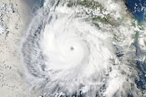





















Tropical Storm Son-tinh blew over the South China Sea, midway between the Philippines and Vietnam, on October 26, 2012. The Moderate Resolution Imaging Spectroradiometer (MODIS) on NASA’s Terra satellite took this picture the same day. Although Son-tinh did not boast a distinct eye, it still had the apostrophe shape typical of a strong storm.
Son-tinh formed as a tropical depression over the western Pacific Ocean on October 23 and strengthened into a storm the next day. On October 26, the U.S. Navy’s Joint Typhoon Warning Center (JTWC) reported that Son-tinh was located about 355 nautical miles (655 kilometers) east of Hue, Vietnam. The storm had maximum sustained winds of 60 knots (110 kilometers per hour) and gusts up to 75 knots (140 kilometers per hour). Son-tinh was expected to gain strength over the next 24 hours, and the JTWC projected storm track showed the storm moving toward the northwest, making landfall in Vietnam.
References & Resources
- Joint Typhoon Warning Center. Accessed October 26, 2012.
- Unisys Weather. (2012, October 26) Son-tinh Tracking Information. Accessed October 26, 2012.
NASA image courtesy LANCE MODIS Rapid Response Team at NASA GSFC. Caption by Michon Scott.