


![Request for Information – Potential [Placeholder for Prize]](https://assets.science.nasa.gov/dynamicimage/assets/science/psd/solar/2023/09/s/solarsystem_0.jpg?w=1024)


May 13, 2014
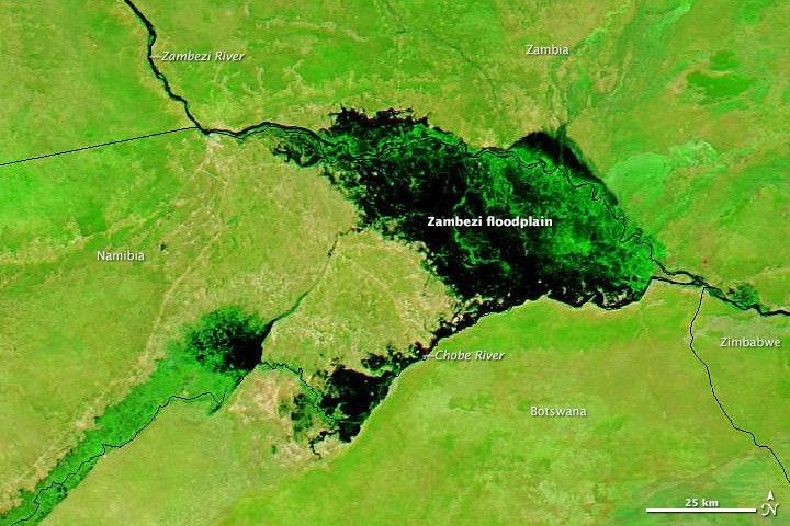
Flooding on the Zambezi River
Every fall, Africa’s Zambezi and Chobe rivers swell with seasonal rain, causing the rivers to overflow into broad floodplains. This year was no exception. When the Moderate Resolution Imaging Spectroradiometer (MODIS) on the Aqua satellite passed Namibia’s Zambezi Region on May 13, 2014, it captured imagery showing widespread flooding.
In this false-color image, which was made with both infrared and visible light, floodwater appears black. Vegetation is bright green, and bare ground is brown. For comparison, the lower image shows the same area on February 21, 2014. Floodwater swamped a few villages, forced evacuations, and closed schools. But, overall, damage caused by flooding in 2014 was less severe than in previous years, according to media reports.
Satellites can be useful for monitoring floods in this remote region. The European Space Agency recently launched a satellite with a radar that Namibian authorities used to monitor this year’s flooding. Meanwhile, the Dartmouth Flood Observatory calculates the magnitude of flooding at sites along both the Zambezi and Chobe rivers based on data from NASA satellites. The Namibia Flood Dashboard is an online portal developed by NASA and the Open Cloud Consortium that includes multiple layers of satellite data that can be used to monitor and forecast flooding events.
For more information about the geology that defines the floodplain, read this story.
Further Reading
- Earth Observatory (2010, June 1) Zambezi Floodplain, Namibia. Accessed May 14, 2014.
- European Space Agency (2014, March 9) Sentinel-1 Aids Response to Namibia Flood. Accessed May 14, 2014.
- Floodlist (2014, March 17) Evacuations After Floods in Zambezi, Namibia. Accessed May 14, 2014.
- Informante (2014, May 8) Waters subside in Zambezi. Accessed May 14, 2014.
- Open Cloud Consortium (2014, May 14) Namibia Flood Dashboard. Accessed May 14, 2014.
- New Era (2014, May 14) Swamped schools resume classes. Accessed May 14, 2014.
References & Resources
NASA images courtesy of the LANCE/EOSDIS Rapid Response team. Caption by Adam Voiland, with information from Robert Brackenridge (Dartmouth Flood Observatory) and Paulina Mufeti (Namibia Ministry of Agriculture, Water, and Forestry).


