


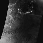
Typhoon Neoguri pounded Okinawa and other Western Pacific islands with torrential rain and damaging winds in mid-July 2014, en route to a likely landfall in Japan. The Visible Infrared Imaging Radiometer Suite (VIIRS) on the Suomi NPP satellite captured this nighttime image of the storm at 2:07 a.m. Japan Standard Time on July 9, 2014 (17:07 Universal Time on July 8). At the time, Neoguri was a category 2 typhoon moving through the East China Sea.
The storm was imaged by a special “day-night band” that detects light in a range of wavelengths from green to near-infrared and uses light intensification to detect dim signals. The instrument can sense light as much as 100,000 times fainter than conventional visible-light sensors, making it very sensitive to moonlight and city lights. In this case, the cloud tops were lit by the nearly full Moon.
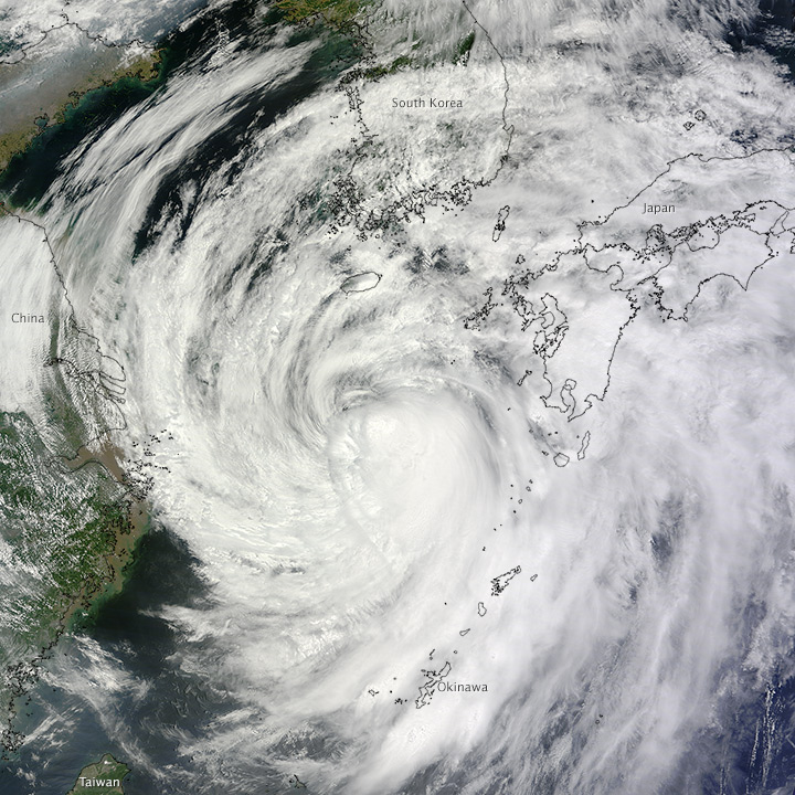
The Moderate Resolution Imaging Spectroradiometer (MODIS) on NASA’s Terra satellite captured a natural-color image (below) of Neoguri at 11:30 a.m. local time (0230 Universal Time) on July 9, 2014.
NASA and other agencies have satellites observing the storm from several angles and with different kinds of sensors. For instance, Cloudsat acquired a cross-section of the vertical cloud structure of Neoguri (click here) during a satellite overpass on July 5. The Tropical Rainfall Measurement Mission captured these views of the intensity of rainfall, convection, and the height of the cloud tops on July 8. And the Atmospheric Infrared Sounder on NASA’s Aqua satellite observed cloud-top temperatures. Though these measurements have some immediate value for monitoring cyclones, the greater value lies in helping scientists understand the fundamentals of these storm systems and in developing models of their development and evolution.
The U.S. Navy’s Joint Typhoon Warning Center reported at 9 p.m. local time (1200 UTC) on July 9 that the storm carried sustained winds of approximately 60 knots (70 miles or 110 kilometers per hour), just short of typhoon status. Maximum significant wave height was 25 feet (7.5 meters). Neoguri was centered at 31.80° North latitude and 127.80° East longitude and approaching the Japanese island of Kyushu. Meteorologists had the storm tracking directly over Kyushu, Shikoku, and Honshu.
References & Resources
- Japan Meteorological Agency (2014) Tropical Cyclone Information. Accessed July 9, 2014.
- Joint Typhoon Warning Center (2014) Current Northwest Pacific/North Indian Ocean Tropical Systems. Accessed July 9, 2014.
- NASA (2014) Hurricanes/Tropical Cyclones. Accessed July 9, 2014.
- Unisys Weather (2014) Neoguri Tracking Data. Accessed July 9, 2014.
NASA Earth Observatory images by Jesse Allen, using VIIRS day-night band data from the Suomi National Polar-orbiting Partnership. Suomi NPP is the result of a partnership between NASA, the National Oceanic and Atmospheric Administration, and the Department of Defense. Terra MODIS image by Jeff Schmaltz, LANCE/EOSDIS Rapid Response. Caption by Michael Carlowicz.


