


November 2, 2016
A Stream of Smoke in Northern India
The Indian state of Punjab is known as India’s breadbasket. Despite its relatively small size, Punjab ranks among the nation’s top wheat and rice producers. For a few weeks in October and November, Punjab also becomes a major producer of air pollution.
Punjab has two growing seasons and two main crops. Rice is planted in May and grown through September; wheat is planted in November and grown through April. Since rice leaves behind a significant amount of plant debris after harvest, many farmers burn the leftover debris in October and November to quickly prepare their fields for the wheat crop.
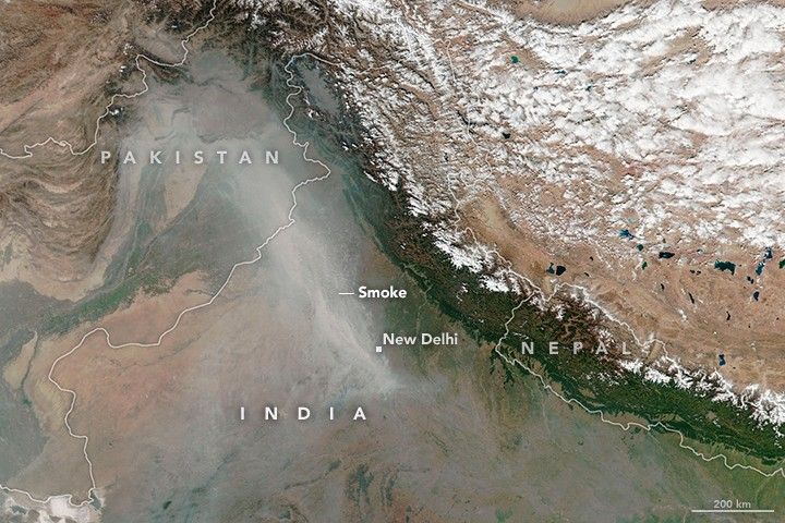
In early October 2016, Earth-observing satellites began to detect small fires in Punjab, and the number of fires increased rapidly in the following weeks. By November, thousands of fires burned across the state, and a thick pall of smoke hovered over India. The Visible Infrared Imaging Radiometer Suite (VIIRS) on the Suomi NPP satellite captured a natural color image on November 2, 2016. The map (second image) shows the locations of the fires VIIRS also detected.
Since the fires are small, short-lived, and burn at relatively low-temperatures, the smoke generally stays near the surface. On November 2, winds carried a stream of smoke—likely mixed with small particles of soil, dust, and partially burned plant material—toward New Delhi. The smoke from Punjab combined with urban pollution from vehicles, industry, and fireworks to push levels of particulate matter in the capital city to unusually high levels.
The number of fires in Punjab generally decreases by the middle of November, according to a study of satellite data collected between 2004 and 2014.
References & Resources
- India Punjab Pollution Control Board. Accessed November 4, 2016.
- The New York Times (2016, November 2) Farmers’ Unchecked Crop Burning Fuels India’s Air Pollution. Accessed November 4, 2016.
- The Wall Street Journal (2016, November 2) Air Pollution in New Delhi Gets Dangerously High During Diwali Celebrations. Accessed November 4, 2016.
- Thumaty, K. et al. (2015, November 25) Monitoring seasonal progress of rice stubble burning in major rice growing districts of Haryana, India, using multidate AWiFS data. Current Science, 109 (10).
- U.S. Department of State New Delhi. Accessed November 4, 2016.
NASA Earth Observatory images by Joshua Stevens, using VIIRS data from the Suomi National Polar-orbiting Partnership and the Fire Information for Resource Management System (FIRMS). Suomi NPP is the result of a partnership between NASA, the National Oceanic and Atmospheric Administration, and the Department of Defense. Caption by Adam Voiland.


