

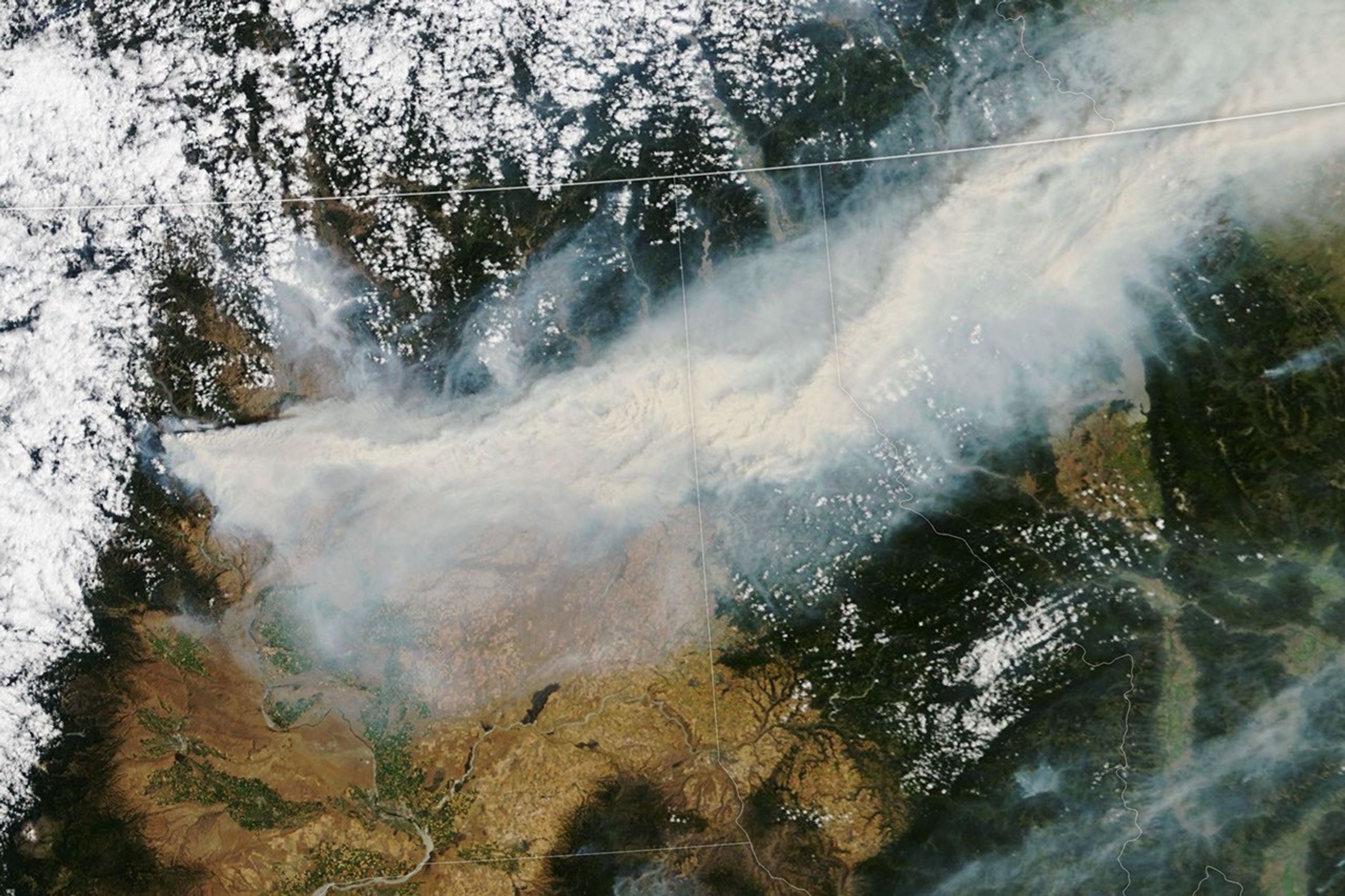
The start of August 2026 saw ongoing and new wildland fires burning in eastern Washington. West of Chelan, the Little Giant fire continued to produce heavy smoke, while a cluster of smaller fires farther east near Spokane affected tens of thousands of people.
The smoke from these and other fires poured east-northeast across the state and into Idaho, Montana, and several Canadian provinces on the morning of August 2, 2026, when NASA’s Terra satellite captured this image.
At that time, the Little Giant fire had burned more than 38,500 acres (15,600 hectares) and was zero percent contained, according to the fire’s incident management team. After lightning ignited the fire on July 15, gusting winds drove the blaze east to Lake Chelan, with spotting reaching the opposite side of the lake. Smoke from the fire was expected to cause unhealthy to very unhealthy air quality in Chelan to the east and unhealthy conditions in Leavenworth and Wenatchee to the south, according to a smoke outlook issued by the U.S. Interagency Wildland Fire Air Quality Response Program.
Meanwhile, the Spokane Area fires—which include the Old Trails fire, Fairview fire, and Autumn Lane fire—had burned around 5,400 acres (2,200 hectares) since igniting the day before. By the morning of August 3, that number had grown to more than 8,000 acres, according to InciWeb. Preliminary reports indicated more than 600 structures had been destroyed or damaged, and mandatory evacuation orders were in place for parts of Spokane County and Stevens County. Widespread smoke from these and the other fires in the state combined to produce very unhealthy air quality in parts of the two counties.
These fires were part of an active fire season fueled by persistent drought and extreme fire weather. Strong winds, high temperatures, and dry fuels led the National Weather Service to issue Washington’s first-ever “particularly dangerous situation alert” on July 31, a designation typically reserved for the most severe fire conditions.
Drought—declared in the state following a warm winter and low snowpack—left vegetation primed to burn. By the start of August, those conditions had helped fuel more than 1,000 fires that burned about 425,000 acres since the start of the year, the most since 2021, according to the Washington State Department of Natural Resources. Of those, 12 large fires remained active, together accounting for more than 200,000 acres burned.
The NASA Disasters Program has been activated to support agencies responding to the fires. The team will be posting maps and data products on its open-access mapping portal as new information becomes available.
NASA Earth Observatory image by Lauren Dauphin, using MODIS data from NASA EOSDIS LANCE and GIBS/Worldview. Story by Kathryn Hansen.
References & Resources
- InciWeb (2026, August 3) Little Giant Fire. Accessed August 3, 2026.
- InciWeb (2026, August 3) Spokane Area Fires. Accessed August 3, 2026.
- Spokane Regional Clean Air Agency (2026, August 3) Current Air Quality. Accessed August 3, 2026.
- U.S. Interagency Wildland Fire Air Quality Response Program (2026, August 3) Smoke Outlook: North Central Washington – Little Giant. Accessed August 3, 2026.
- Washington Governor Bob Ferguson (2026, August 1) Governor Ferguson declares statewide wildfire emergency, issues statewide burn ban. Accessed August 3, 2026.
- Washington State Department of Natural Resources (2026, July 31) With 10 Large Wildfires Burning Across 200,000 Acres and Extreme Fire Conditions Ahead, DNR Shores up Resources With The National Guard. Accessed August 3, 2026.