


Within the span of one week, two tropical cyclones barreled down on the Middle East.
Tropical Cyclone Sagar was the first to hit, making landfall in Somalia on May 19, 2018. On that day, the Moderate Resolution Imaging Spectroradiometer (MODIS) on NASA’s Aqua satellite acquired a natural-color image (above) of the storm. Maximum sustained winds reached 55 knots (65 miles or 100 kilometers per hour)—the equivalent of a tropical storm on the Saffir-Simpson scale. The storm delivered more than a year’s worth of rain to parts of the country, which has been coping with years of drought. According to Reliefweb, damage from Sagar’s floodwaters and wind displaced hundreds of thousands of people.
According to NOAA’s database of historical hurricane tracks, tropical cyclones are infrequent in this part of the Arabian Sea, and the region can go years without a storm. When they develop, they tend to occur in spring and autumn. It is less common for tropical cyclones to travel so far west into the Gulf of Aden. Check out this map to see the tracks of previous storms.
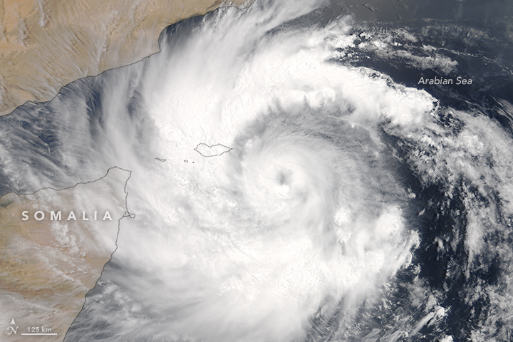
Days after Sagar made landfall, a second tropical cyclone barreled across the Arabian Sea. The second image, acquired by MODIS on NASA’s Terra satellite, shows Tropical Cyclone Mekunu on May 23, 2018. On that day, winds reached 65 knots (75 miles or 120 kilometers per hour)—the equivalent of a category 1 hurricane—and forecasters called for it to continue to strengthen.
Mekunu is not likely to travel as far west as Sagar. Instead, the storm is expected to move north-northwest and make landfall in Oman by about May 26.
References & Resources
- LANCE/EOSDIS Rapid Response (2018, May 19) Tropical Cyclone Sagar (01A) over the Horn of Africa. Accessed May 23, 2018.
- LANCE/EOSDIS Rapid Response (2018, May 23) Tropical Cyclone Mekunu (02A) off the Horn of Africa. Accessed May 23, 2018.
- NOAA (2017, July 25) Historical Hurricane Tracks Accessed May 23, 2018.
- Quartz (2018, May 22) Somalia’s “strongest cyclone on record” has left dozens dead and thousands displaced. Accessed May 23, 2018.
- Reliefweb (2018, May 23) Desert Locust Alert: Tropical Cyclone Mekunu (23 May). Accessed May 23, 2018.
- Reliefweb (2018, May 21) Hundreds of thousands of children affected after Tropical Cyclone Sagar sweeps over Somaliland. Accessed May 23, 2018.
- Unisys (2018, May 19) 2018 Hurricane/Tropical Data for Northern Indian Ocean. Accessed May 23, 2018.
- The Washington Post, Capital Weather Gang (2018, May 23) Middle East mayhem: After rare tropical cyclone Sagar devastates Somalia, a second aims for Oman. Accessed May 23, 2018.
- The Weather Channel (2018, May 23) One Dead as Tropical Cyclone Sagar Brings Life-Threatening Flood Threat to Somalia, Djibouti, Yemen. Accessed May 23, 2018.
NASA images by Jeff Schmaltz, LANCE/EOSDIS Rapid Response . Story by Kathryn Hansen.


