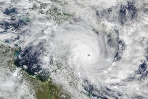
After Subtropical Storm Alberto made landfall in the Florida Panhandle in late May 2018, the storm was downgraded to a subtropical depression. Alberto delivered wind and rain to large swaths of the southeastern United States before spinning up toward the Midwest and Great Lakes.
The Moderate Resolution Imaging Spectroradiometer (MODIS) on NASA’s Aqua satellite captured these images of the storm. The false-color views use MODIS band 31, which measures infrared signals known as brightness temperature. This band is useful for distinguishing cooler cloud structures from the warmer surface below.
The left image shows the storm at 1:25 p.m. Central Time (18:25 Universal Time) on May 30, 2018, as it moved across west-central Indiana. At the time, Alberto had maximum sustained winds of 45 kilometers (30 miles) per hour.
The right image shows the storm at 3:05 a.m. Central Time (08:05 Universal Time) on May 31. By this time, Alberto had become a post-tropical cyclone as it moved from away from lower Michigan toward the north-northeast.
References & Resources
- National Hurricane Center (2018, May 29). Subtropical Storm ALBERTO Advisory Archive. Accessed May 31, 2018.
- National Weather Service, Weather Prediction Center (2018, May 31) Tropical Depression ALBERTO. Accessed May 31, 2018.
- Weather Underground (2018, May 29) Alberto Kills 2 in NC; Downgraded to a Subtropical Depression. Accessed May 31, 2018.
NASA Earth Observatory images by Joshua Stevens, using MODIS data from LANCE/EOSDIS Rapid Response . Text by Kathryn Hansen.

