


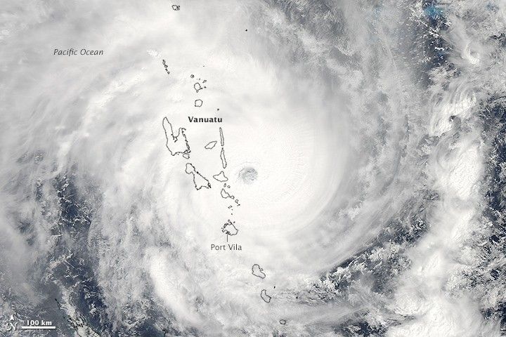
Cyclone Pam was heading in a southwesterly direction when the Moderate Resolution Imaging Spectroradiometer (MODIS) on NASA’s Aqua satellite acquired this image at 1:30 p.m. local time (2:30 Universal Time) on March 13, 2015. Not long after the image was acquired, the storm crossed over the island of Efate, which is home to Vanuatu’s capital city, Port Vila.
The eastern side of Efate likely took the strongest hit from the cyclone’s eyewall, but Port Vila, on the southwestern side of the island, faced extremely destructive conditions. As the storm approached the city, it had sustained winds up to 265 kilometers (165 miles) per hour, making it the equivalent of a category 5 cyclone. Dozens of people are feared dead and forecasters expect flooding and catastrophic damage in the city.
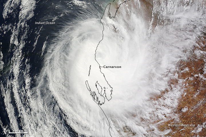
On the same day, another major tropical cyclone—Category 3 Olwyn—made landfall in Western Australia near the city of Carnarvon. The lower image was acquired at 10:55 am local time (2:55 UTC) by MODIS on NASA’s Terra satellite. Thousands of people in Carnarvon lost power as a result of the storm, which weakened as it pushed inland.
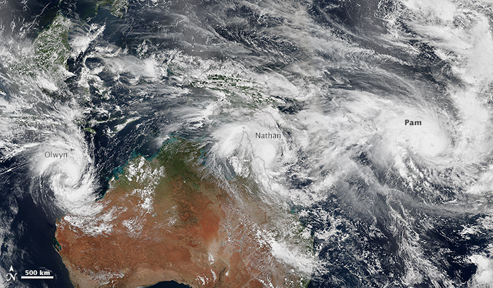
It has been an unusually busy week for tropical cyclones in the vicinity of Australia. The mosaic below shows three storms—Pam, Nathan, and Olwyn—swirling near the continent on March 11, 2015. The mosaic is based on data collected during three orbital passes of the Visible Infrared Imaging Radiometer Suite (VIIRS) on Suomi NPP. Other satellite instruments that can observe more of Earth’s surface at once captured views with a fourth tropical cyclone. The fourth storm, Bavi, is in the Pacific Ocean well north of Pam.
Further Reading
- NASA Earth Observatory (2013, March 5) In a Warming World, Storms May Be Fewer but Stronger.
References & Resources
- ABC News (2015, March 13) Cyclone Olwyn: Storm lashes coastal communities in WA's Mid West; downgraded to category two. Accessed March 13, 2015.
- Bureau of Meteorology (2015, March 13) Current Tropical Cyclones. Accessed March 13, 2015.
- Joint Typhoon Warning Center (2015, March 13) Tropical Cyclone Pam Warning. Accessed March 13, 2015.
- Masters, J. via Weather Underground (2015, March 13) Category 5 Tropical Cyclone Pam Makes a Direct Hit on Vanuatu. Accessed March 13, 2015.
- Freedman, A. via Mashable (2015, March 13) Catastrophic damage feared in tiny Vanuatu after Category 5 Cyclone Pam. Accessed March 13, 2015.
- The Weather Channel (2015, March 13) Four Tropical Cyclones At Once : How Rare Is It? Accessed March 13, 2015.
- Weather Network (2015, March 13) Satellite image shows four cyclones near Australia. Accessed March 13, 2015.
- Washington Post (2015, March 13) Tropical Cyclone Pam thrashes Vanuatu with direct hit as a Category 5. Accessed March 13, 2015.
NASA images courtesy Jeff Schmaltz, LANCE/EOSDIS MODIS Rapid Response Team at NASA GSFC. NASA VIIRS image by Jesse Allen, using data from the Suomi National Polar-orbiting Partnership. Suomi NPP is the result of a partnership between NASA, the National Oceanic and Atmospheric Administration, and the Department of Defense. Caption by Adam Voiland.


