February 14, 2017
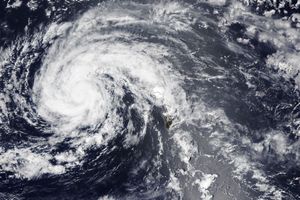
On February 14, 2017, Tropical Cyclone Dineo was gaining strength as it moved southwestward over the waters of the Mozambique Channel. That same day, the Moderate Resolution Imaging Spectroradiometer (MODIS) on NASA’s Terra satellite captured this image of the storm at 10:45 a.m. local time (7:45 Universal Time), when it was centered just west of Europa Island.
A few hours later (12:00 Universal Time), the Joint Typhoon Warning Center reported maximum sustained winds of 55 knots (60 miles per hour). Forecasters predicted the storm would continue strengthening over the next 24 hours before making landfall over southern Mozambique.
References & Resources
- Joint Typhoon Warning Center (2017, February 14) Tropical Cyclone 05S (Dineo) Warning #3 (graphic). Accessed February 14, 2017.
- Joint Typhoon Warning Center (2017, February 14) Tropical Cyclone 05S (Dineo) Warning #3 (text). Accessed February 14, 2017.
- Unisys Weather (2017) Dineo. Accessed February 14, 2017.
NASA image by Jeff Schmaltz, LANCE/EOSDIS Rapid Response. Caption by Kathryn Hansen.