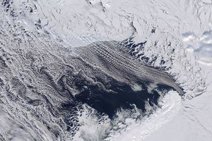
A little more than 500 miles off of West Antarctica, a series of clouds in thin, parallel lines stretched over the open water of the Amundsen Sea. The Moderate Resolution Imaging Spectroradiometer captured the scene on September 12, 2018.
The long parallel bands of cumulus clouds—called cloud streets—are ultimately the visible result of nature trying to balance differences in energy. Columns of heated air called thermals rise through the atmosphere, moving heat away from the sea surface. The air masses rise until they hit a warmer air layer (temperature inversion). This layer acts like a lid, causing the rising thermals to roll over and loop back on themselves, forming parallel cylinders of rotating air. On the upper side of these cylinders (rising air), clouds form. Along the downward side (descending air), skies are clear.
In this case, cool air likely was blowing out from Antarctica and the sea ice cover. As it reached warmer, open water, the winds would have picked up heat and moisture to make the thermals and clouds.
References & Resources
- NASA Earth Observatory (2018, March 30) Cloud Streets and Ice in the Barents Sea.
NASA Earth Observatory image by Lauren Dauphin, using MODIS data from LANCE/EOSDIS Rapid Response . Text by Kasha Patel.


