


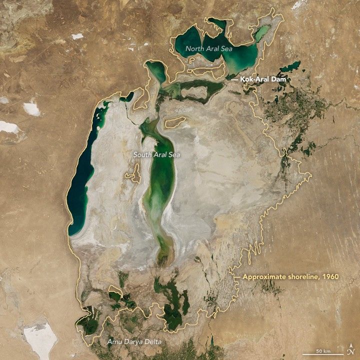
What remains of the large inland lake is a fraction of what it was in the 1950s and 60s. In those years, the government of the former Soviet Union diverted so much water from the Amu Darya and Syr Darya—the regions’s two major rivers—to irrigate farmland, that it pushed the hydrologic system beyond the point of sustainability. During subsequent decades, the fourth largest lake in the world shrank to roughly a tenth of its former size and divided into several smaller bodies of water.
The image above, captured by the Moderate Resolution Imaging Spectroradiometer (MODIS) on NASA's Terra satellite, shows the Aral Sea in Central Asia on August 22, 2017. While the lake was much smaller in August 2017 than it was in the 1960s, some growth in the eastern lobe of the South Aral represents an improvement over August 2014, when that lobe was completely dry.
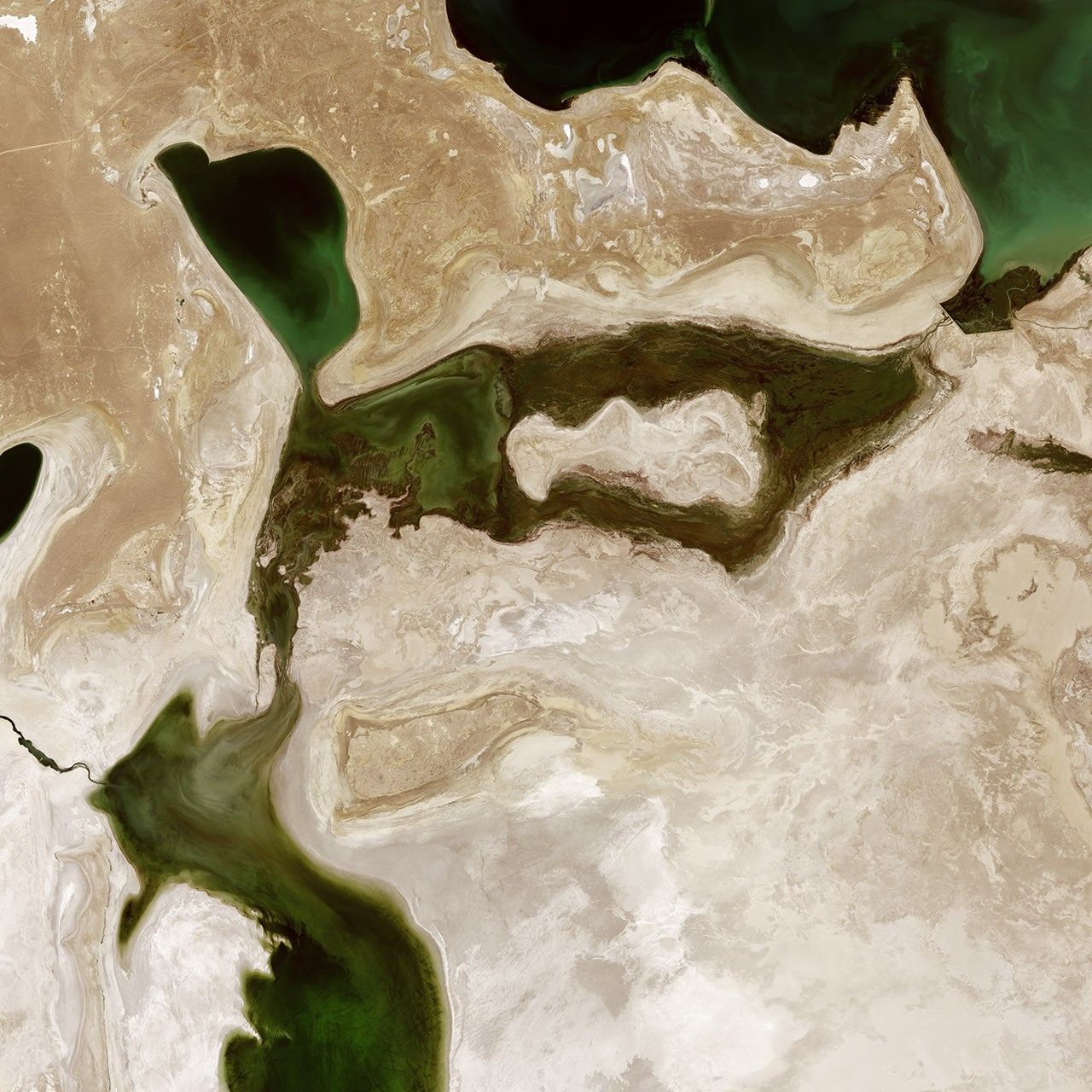
Instead of pooling in one large basin, water flowing down the two rivers now ends up in either the North Aral Sea (fed by the Syr Darya) or the South Aral Sea (fed by Amu Darya). The Kok-Aral dike and dam, finished in 2005, separates the two water bodies and prevents flow out of the North Aral into the lower-elevation South Aral. The dam has actually led fisheries in the North Aral Sea to rebound, even as it has limited flow into the South basin.
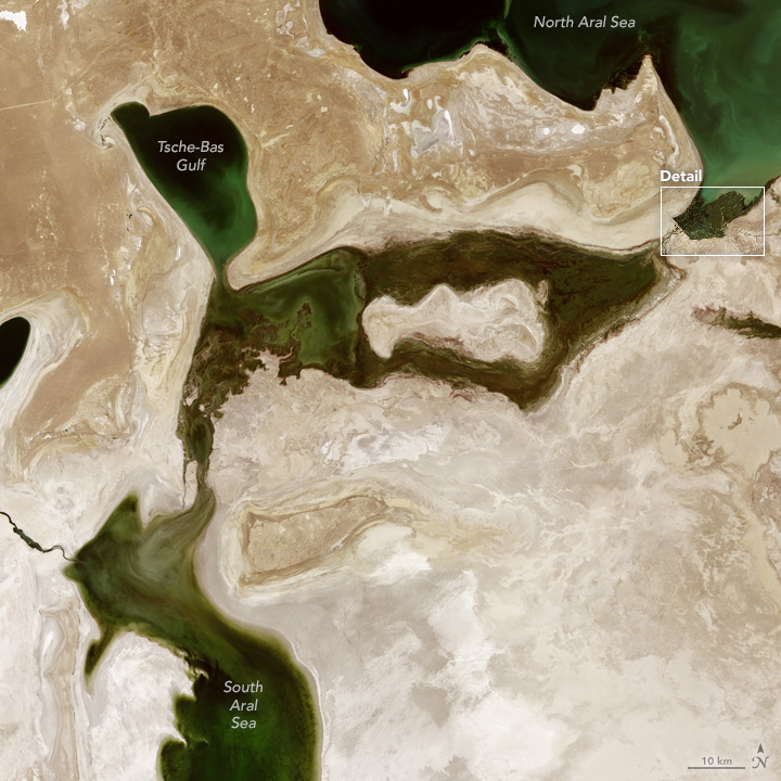
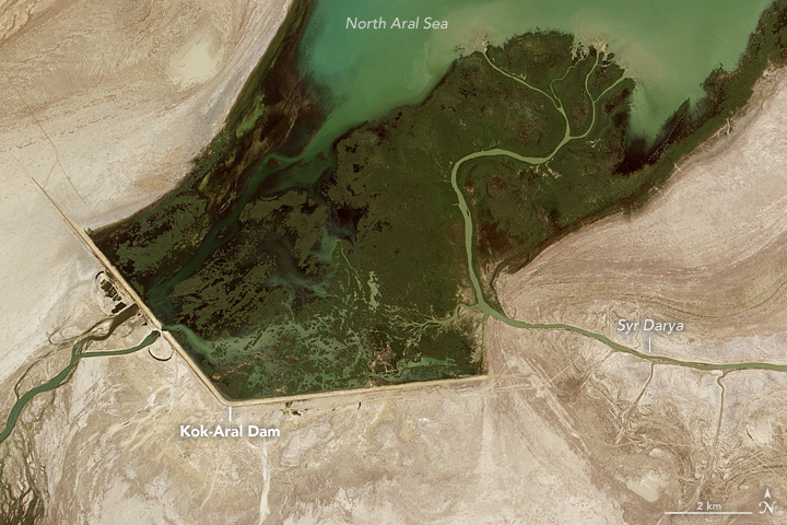
Managers use a sluice gate to let some water flow from the North Aral into the South Aral. During wet and snowy years, these releases are common; in dry years, they are rare. In 2017, heavy outflow from the North Aral in the winter, spring, and summer caused the eastern lobe of the South Aral to partially refill, explained Philip Micklin, a geographer emeritus from Western Michigan University.
Large releases from the Toktogul Dam, a reservoir on a tributary of the Syr Darya, increased the flow of the Syr in the winter. In the spring, unusually warm temperatures melted enough snow pack and glacial ice in the Tien Shan to keep the river high. To a lesser degree, flow from the Amu Darya may have contributed to the partial replenishment of the eastern lobe in 2017 as well.
The second and third images show the pathway water follows as it flows down the Syr Darya, into the North Aral Sea, and eventually the South Aral Sea. The Operational Land Imager (OLI) on Landsat 8 collected the image on August 5, 2017. At the time, the sluice gates at the dam appeared to be open, and water was flowing past the Tsche-Bas Gulf and into the South Aral.
“However, this year’s events do not signal a restoration of the eastern lobe as a permanent feature,” said Micklin. “Since the early 2000s, the eastern lobe revitalizes during heavy flow years and then dries completely, or nearly completely in low flow years. I see this process continuing for the foreseeable future.”
References & Resources
- NASA Earth Observatory (2012, February 24) The Aral Sea, Before the Streams Ran Dry.
- NASA Earth Observatory (2006, April 11) Aral Sea Expansion.
- NASA Earth Observatory (2000, August 25) World of Change: Shrinking Aral Sea.
- NASA Jet Propulsion Laboratory (2014, February 14) NASA Data Find Some Hope for Water in Aral Sea Basin. Accessed August 28, 2017.
- Micklin, P. (2010, September) The past, present, and future Aral Sea. Lakes & Reservoirs: Research & Management, 15 (3), 193.
- Reuters (2017, June 1) Aral Sea: big fish is back in small pond. Accessed August 28, 2017.
- United Nations (2012) Aral Sea Basin. Accessed August 28, 2017.
NASA Earth Observatory image by Jesse Allen, using Terra MODIS data from the Land Atmosphere Near real-time Capability for EOS (LANCE) and Landsat data from the U.S. Geological Survey. Story by Adam Voiland.


