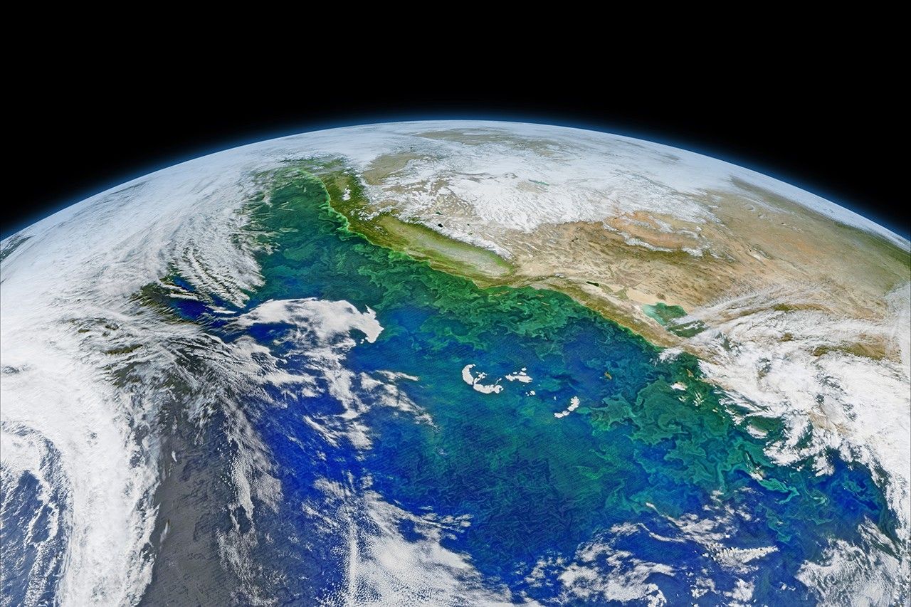
.png?w=1024)


The waters along the west coast of North America are some of the most biologically productive in the world. Cool water from high latitudes flows southward from the edge of British Columbia to Baja; this is the California Current. At the same time, breezes often blow from land to sea and push ocean surface waters away from the coast. As a result, cooler, nutrient-rich water rises up from the depths to take its place—a process known as upwelling.
The combination of cool water and abundant nutrients promotes the growth of plant life in the sea, from microscopic phytoplankton to dense kelp forests. Those plants—primary producers—become the center of a food web that includes highly productive fisheries, sizable populations of marine mammals (whales, seals, dolphins), and vast numbers of sea birds. This productive ecosystem can extend as much as 500 kilometers (300 miles) out from the coast.
On February 8, 2016, the Visible Infrared Imaging Radiometer Suite (VIIRS) on the Suomi NPP satellite captured several images of blooming phytoplankton and swirling currents along the coast of California and western Mexico. The images were stitched together into a composite built with data from the red, green, and blue wavelength bands on VIIRS, along with chlorophyll data. A series of image-processing steps highlighted the color differences and subtle features in the water.
The California Current is what scientists call an eastern boundary current. Strong current systems flow along the east side (or boundary) of all of Earth’s major ocean basins. They tend to move water toward the equator, and they are prone to strong upwelling. That’s because an ocean current moving from north to south along a west coast is pulled away from the shore by Earth’s rotation (the Coriolis effect), leaving a void that allows deep water to fill in behind.
In the image above, note how the green phytoplankton near the coast trace out the meanders and eddies from the California Current. The presence of this cool water current keeps the region’s temperatures milder for much of the year than they otherwise would be.
Recent research suggests that global warming could intensify upwelling in coastal boundary currents, which could change the chemistry of those nearshore waters and possibly have effects on the species that now populate them. Some changes are already underway, as other research projects have detected a decline in the abundance of zooplankton in the region and a deepening of the thermocline—the submarine boundary layer between warmer surface waters and cooler deep waters.
Researchers are also watching the California Current closely this year because El Niño warms the sea more than usual and can reduce upwelling. This leads to increased water temperatures, which in past El Niño events has done real damage to fisheries and the marine mammals that feed on them.
References & Resources
- Central and Northern California Ocean Observing System (2014) Flowing Ocean: Understanding the California Current. Accessed February 25, 2016.
- Bakun, A., et al. (2015) Anticipated Effects of Climate Change on Coastal Upwelling Ecosystems. Current Climate Change Reports, 1 (2), pages 85-93.
- The Encyclopedia of Earth (2011, June 13) California Current large marine ecosystem. Accessed February 25, 2016.
- NOAA Southwest Fisheries Science Center (2014) Research in the California Current. Accessed February 25, 2016.
- NSF Long-Term Ecological Research (2016) California Current Ecosystem. Accessed February 25, 2016.
- Wikipedia (2016) California Current. Accessed February 25, 2016.
NASA image by Norman Kuring, NASA’s Ocean Color Web . Caption by Mike Carlowicz, with aid from Stephanie Schollaert-Uz.