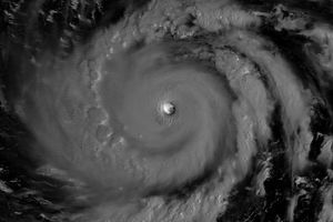



















As of September 12, 2008, the Joint Typhoon Warning Center forecast that Typhoon Sinlaku would give Japan a near miss. The storm was skirting Taiwan at 10:20 a.m. local time (2:20 UTC) on September 12, when the Moderate Resolution Imaging Spectroradiometer (MODIS) on NASA’s Terra satellite captured this photo-like image. The storm’s clouds swirl tightly around a closed, cloudy eye. At the time the image was taken, Sinlaku had winds of 204 kilometers per hour (127 miles per hour or 110 knots) with stronger gusts, making it the equivalent of a strong Category 3 storm. Sinlaku was forecast to intensify, but, as of September 12, was not on course to strike land.
References & Resources
NASA image created by Jesse Allen, using data provided courtesy of the MODIS Rapid Response team. Caption by Holli Riebeek.