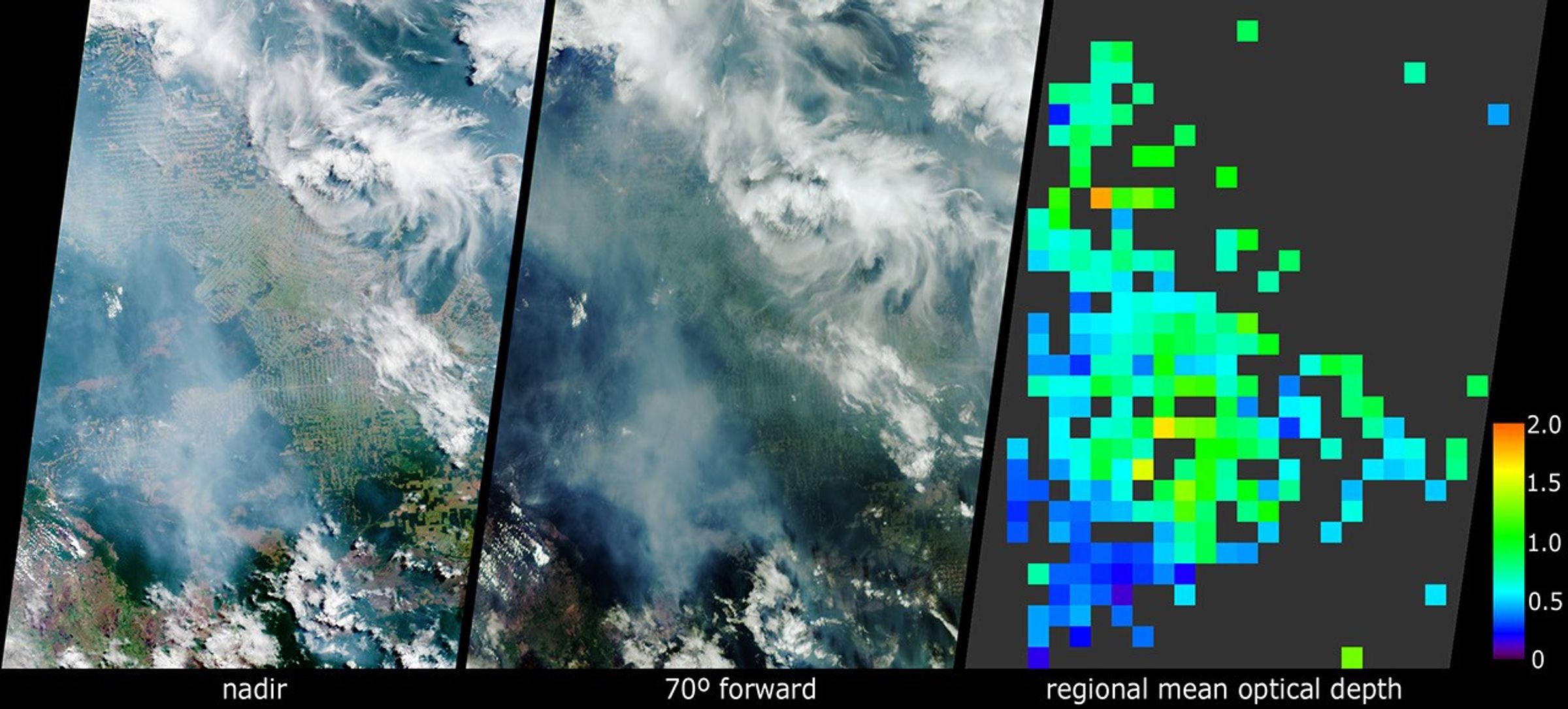
In the Brazilian state of Rondonia, scientists have gathered to study gases andairborne particles produced in the tropics. Between September and November 2002,they are conducting integrated airborne and ground-based measurements aimed atbetter understanding the role these constituents play in Earth’s climate. Theseviews from the Multi-angle Imaging SpectroRadiometer (MISR) show extensiveplumes of fine particles emanating from burning vegetation within Rondonia. Thedata were acquired on September 15, the official start date for the Amazonburning season, and one week into the field study, which is called theCooperative Large-scale-biosphere-atmosphere Airborne Regional Experiment, orCLAIRE.
The left-hand panel is a natural-color view acquired by MISR’svertical-viewing (nadir) camera. The center image covers the same geographicarea, as seen by the 70-degree forward-viewing MISR camera. The appearance ofsmoke and haze is enhanced in the oblique view, whereas the herringbone patternsof deforestation are more evident in the nadir image. Due to geometric parallax,clouds appear to move relative to the ground between these two images. At rightis a map of aerosol optical depth, a measure of the amount of particulates inthe atmosphere, derived from the MISR multi-angle views. Haze distributed acrossRondonia shows up as light blue and green pixels across the region. Places whereclouds or other factors precluded an aerosol retrieval are shown in dark grey.
The main measurement site for the CLAIRE campaign is a field near the town ofJi-Parana, somewhat below and to the right of the MISR image centers. It iswell-situated to observe the thick palls of smoke originating in densevegetation to the south and east, at the eastern end of the Parque Nacional dePacaas Novos. The CLAIRE aircraft will follow these plumes as they spread overthe region, and will measure the changing characteristics of the smoke particlesas they age. The southern edges of these images extend into Bolivia, where morefires are burning near the Brazil-Bolivia border. Clearer skies in the southeastcorner of the image area are associated with higher-elevation lands along theSerra dos Parecis mountains.
The Multi-angle Imaging SpectroRadiometer observes the daylit Earthcontinuously from pole to pole, and every 9 days views the entire globe between82 degrees north and 82 degrees south latitude. The MISR Browse Image Viewer provides access tolow-resolution true-color versions of these images. These data products weregenerated from a portion of the imagery acquired during Terra orbit 14595. Thepanels cover an area of about 400 kilometers x 563 kilometers, and utilize datafrom blocks 98 to 101 within World Reference System-2 path 231.
Further information about the CLAIRE campaign, and theLarge-scale-Biosphere-Atmosphere (LBA) study program may be found at:LBA-CLAIRE andthe LBA page at Oak Ridge National Laboratory.
References & Resources
Image courtesy NASA/GSFC/LaRC/JPL, MISR Team.