


browse image of orbit 16858 (270 KB JPEG)
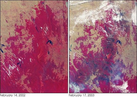
More than 2 million acres were consumed by hundreds of fires betweenDecember 2002 and February 2003 in southeastern Australia’s nationalparks, forests, foothills and city suburbs. These images were acquiredon February 14, 2002 (left) and February 17, 2003 (right) by theMulti-angle Imaging SpectroRadiometer (MISR) instrument onboard NASA’sTerra satellite. The year 2002 was one of Australia’s hottest and drieston record, and the acreage burnt during the summer 2002-2003 fire seasonin Victoria, the Australian Capital Territory and southern New SouthWales, is the largest since 1938-1939, when more than 3 million acreswere scorched.
The extent of the burnt area and the dry conditions as of February 2003are indicated by these contrasting false-color views. Both image panelsdisplay data from the near-infrared, red and blue spectral bands ofMISR’s downward-viewing (nadir) camera, as red, green and blue,respectively. This display technique causes healthy vegetation to appearred and burnt areas to show as dark brown. The data displayed from thetwo dates were processed identically to preserve relative brightnessvariations. Vegetation changes related to the dry conditions (notrelated to the brown burn scars) are also indicated in the February 2003panel, where many previously red areas exhibit instead the paleyellow-brown of the underlying soils and geology. Significant reductionin the surface area of several large and important water bodies are alsoapparent. The diminished extent of Lake Hume (along the left-hand edge)in the later date provides a good example.
The Multi-angle Imaging SpectroRadiometer observes the daylit Earthcontinuously and every 9 days views the entire globe between 82 degreesnorth and 82 degrees south latitude. The MISR Browse Image Viewer provides access tolow-resolution true-color versions of these images. These data products were generatedfrom a portion of the imagery acquired during Terra orbits 14999 and16858. The panels cover an area of about 208 kilometers x 286kilometers, and utilize data from blocks 118 to 121.
References & Resources
Image courtesy NASA/GSFC/LaRC/JPL, MISR Team. Text by Clare Averill (Acro Service Corporation/JPL)
None


