![Request for Information – Potential [Placeholder for Prize]](https://assets.science.nasa.gov/dynamicimage/assets/science/psd/solar/2023/09/s/solarsystem_0.jpg?w=1024)


The South Sandwich Islands are a remote group of eleven small volcanic peaks arranged in an arc in the southern Atlantic Ocean. They sit about 1,000 miles (1,600 kilometers) northeast of the Antarctic Peninsula and within the Scotia Sea, a frigid body of water littered with icebergs and under the sway of the powerful Antarctic Circumpolar Current.
Spread across an often cloudy region known as the Furious Fifties, the steep, conical islands have persistent westerly winds sweeping past them. This combination of winds and topography helps produce a range of unusual and beautiful cloud types, including wave clouds, volcano tracks, and lenticular clouds.
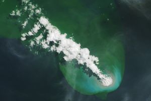
Whorls of air rotating in alternating directions formed behind three of the islands—Visokoi, Candlemas, and Saunders—to create the swirling patterns seen in this image, captured by the VIIRS (Visible Infrared Imaging Radiometer Suite) on the NOAA-20 satellite on February 24, 2025.
The trails are called von Kármán vortex streets, a distinctive pattern that can occur when a fluid passes a tall, isolated, stationary object. The features are most likely to appear in Earth’s atmosphere when winds of moderate strength—between 18 and 56 kilometers (11 and 34 miles) per hour—push marine stratocumulus clouds past tall geographic features in relatively stable atmospheric conditions. If winds are too weak, clouds simply flow smoothly around the obstacles. If they are too strong, vortices break apart and cannot maintain their shape.
The features are named after Theodore von Kármán—an accomplished mathematician, aerospace engineer, and one of the Jet Propulsion Laboratory’s founders. He was the first to describe the oscillating flow features in mathematical terms while working as a graduate assistant in 1911.
Small particles produced by volcanic activity also appear to have slightly brightened the trail of clouds extending from Saunders Island, explained Santiago Gassó, a University of Maryland atmospheric scientist. Gassó has studied how weak volcanic activity from the island’s Mount Michael volcano regularly modifies passing clouds.
Scientists have observed cloud brightening—also called the Twomey effect—for decades. Clouds with extra particles from volcanic emissions have more and smaller cloud droplets than normal clouds. This means there are more surfaces to reflect light, making volcanically “polluted” clouds appear brighter than others. The same process produces bright ship track clouds over the ocean, except in that case the extra particles come from ship exhaust.
“A volcano track is most noticeable in marine stratus cloud decks when the cloud base is within a few hundred meters from the volcano top,” Gassó said. “That is often the case at Saunders Island and other high-latitude islands. It is less common to see the phenomenon in tropical regions,” he said.
Satellite observations indicate that emissions of sulfur dioxide and other gases are common at Mount Michael, which has a lava lake roiling deep inside its central crater and has been weakly erupting since 2014. Multiple satellite sensors, including the TROPOMI (Tropospheric Monitoring Instrument) on Sentinel-5P, observed enhanced levels of sulfur dioxide on February 24, said Michigan Tech volcanologist Simon Carn.
“The South Sandwich Islands are an excellent ‘natural laboratory’ for studying the impact of volcanic emissions on clouds,” Carn said. “But we have to rely on satellite observations due to the inaccessibility and remoteness of the islands.”
To the west of the island chain, several small icebergs float visibly beneath a thin cloud layer. The Antarctic Circumpolar Current often steers icebergs, which have broken off ice shelves in Antarctica, toward the Scotia Sea—an area known among glaciologists as a place where icebergs go to die as they encounter warmer water and air.
Though the incoming icebergs will not last forever, they may be helping support life in the region. Some research indicates that icebergs drifting into the Scotia Sea are often hotspots of biogeochemical and ecological activity, bringing elevated numbers of phytoplankton, krill, and seabirds with them.
Should any of these seabirds find their way to Zavodovski Island, they will have company. The island is thought to have one of the largest colonies of chinstrap penguins in the world. The South Sandwich Islands are also frequented by seals, whales, and several types of fish.
References & Resources
- Collins, M., et al. (2022) South Sandwich Islands—An understudied isolated Southern Ocean archipelago. Topical Studies in Oceanography, 201, 105121.
- Gassó, S. (2008) Satellite observations of the impact of weak volcanic activity on marine clouds. Journal of Geophysical Research: Atmospheres, 113(D14).
- Holdgate, M. & Baker, P. (1979) The South Sandwich Islands. Scientific Reports, 91.
- Liu, E., et al. (2021) Volcanic activity and gas emissions along the South Sandwich Arc. Bulletin of Volcanology, 83(3).
- NASA (2025, February 24) South Sandwich Islands, South Atlantic (TROPOMI). Accessed March 13, 2025.
- NASA Science Focus: Von Karman Vortices. Accessed March 13, 2025.
- NASA Earth Observatory (2021, January 5) The Stability of von Kármán’s Vortices. Accessed March 13, 2025.
- NASA Earth Observatory (2020, June 23) Volcanic Emissions Can Change Clouds. Accessed March 13, 2025.
- Ruhl, H., et al. (2011) Seabird aggregation around free-drifting icebergs in the northwest Weddell and Scotia Seas. Deep Sea Research Part II: Topical Studies in Oceanography, 58(11-12), 1497-1504.
NASA Earth Observatory image by Wanmei Liang, using VIIRS data from NASA EOSDIS LANCE, GIBS/Worldview, and the Joint Polar Satellite System (JPSS). Story by Adam Voiland.