


.png?w=1024)


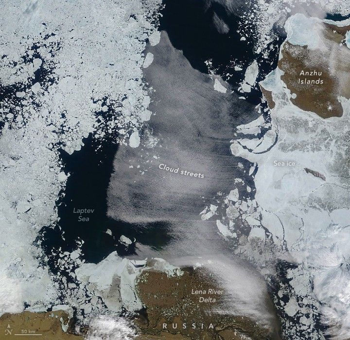
In July 2025, a striking cloud formation developed over the Laptev Sea north of Siberia. The long, parallel bands of cumulus clouds, known as cloud streets, can form here when frigid Arctic air blows across the sea ice and over areas of comparatively warm open water.
A healthy mix of sea ice and open water was present in the Laptev Sea on July 10, 2025, when the MODIS (Moderate Resolution Imaging Spectroradiometer) on NASA’s Terra satellite acquired this image. These conditions likely contributed to the formation of the cloud streets, which are the visible result of the atmosphere’s response to imbalances in the distribution of energy.
Cloud streets can form as the “warm” open water gives up heat and moisture to the cold air, leading columns of heated air (thermals) to rise through the atmosphere. The air masses rise until they hit a warmer air layer (temperature inversion). This layer acts like a lid, causing the rising thermals to roll over and loop back on themselves, forming parallel cylinders of rotating air. On the upper side of these cylinders (rising air), clouds form. Along the downward side (descending air), skies are clear.
Winds on July 10 were also favorable for the formation of this cloud type. According to Scott Bachmeier, a meteorologist with the Cooperative Institute for Meteorological Satellite Studies at the University of Wisconsin-Madison, model analyses showed a tight pressure gradient between an area of low pressure near the North Pole and high pressure over the Siberian coast.
“Strong offshore winds exiting the sea ice edge and moving across the open water would definitely support the formation of the cloud streets seen in the image,” Bachmeier said.
It’s harder to say, however, what might have caused the sharp edge on the cloud’s northern side. Bachmeier speculated that it could mark the leading edge of a pulse of warm air near the surface.
The image captures the Laptev Sea at a transitional time of year. Seasonal melting in 2025 was underway across the Arctic Ocean by late May, with areas of open water showing up in the Laptev Sea in June, according to the National Snow and Ice Data Center. By autumn, the region will begin to refreeze.
References & Resources
- NASA Earth Observatory (2025, April 4) Winter Sea Ice Reached New Lows in the Arctic. Accessed July 17, 2025.
- NASA Earth Observatory (2018, March 30) Cloud Streets and Ice in the Barents Sea. Accessed July 17, 2025.
- National Snow and Ice Data Center (2025, July 9) SSMIS sunsets AMSR2 rises. Accessed July 17, 2025.
NASA Earth Observatory image by Michala Garrison, using MODIS data from NASA EOSDIS LANCE and GIBS/Worldview . Story by Kathryn Hansen


