


June 26-July 16, 2025
Rare Snowfall in the Atacama Desert
The Atacama Desert’s location, between the Andes Mountains to the east and the cool Peru/Chile Current to the west, makes it one of the driest places on Earth. The mountain range produces a rain shadow, while the current chills the air enough to limit evaporation and cloud development.
But occasionally, cold-core cyclones that drift into low latitudes—cutoff lows—puncture these defenses and bring rain or snow to the region. That’s what happened on June 25, 2025, when a rare snowstorm blanketed much of the higher-elevation Altiplano portion of the desert in white. It also delivered heavy rains farther to the south.
“Cutoff lows are more frequent in the subtropics, but from time to time they can reach northern Chile, where they explain most of the winter precipitation in the Atacama,” explained René Garreaud, an atmospheric scientist at the University of Chile.
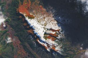
Among the places that received snow was the Chajnantor Plateau in northern Chile. Perched more than 5,000 meters (16,000 feet) above sea level, the plateau has exceptionally clear and dry skies, qualities that have helped turn it into a hub of astronomical research.
According to news reports, the Atacama Large Millimeter/submillimeter Array (ALMA), one of the most powerful radio telescopes on Earth, had to temporarily suspend operations after the snowfall, which some meteorologists described as the first to fall in the region in more than a decade. (The region also saw a heavy snow event in 2011.)
The MODIS (Moderate Resolution Imaging Spectroradiometer) on NASA’s Terra satellite captured an image (above left) of the snowfall on June 26, 2025, the day after the storm. The same sensor captured the second image on July 16, 2025. The images are false color to help differentiate between areas of snow and ice (blue) and water clouds (white). The OLI-2 (Operational Land Imager) on Landsat 9 captured a more detailed, natural-color view of the remaining snow on the plateau on July 10, 2025 (below).
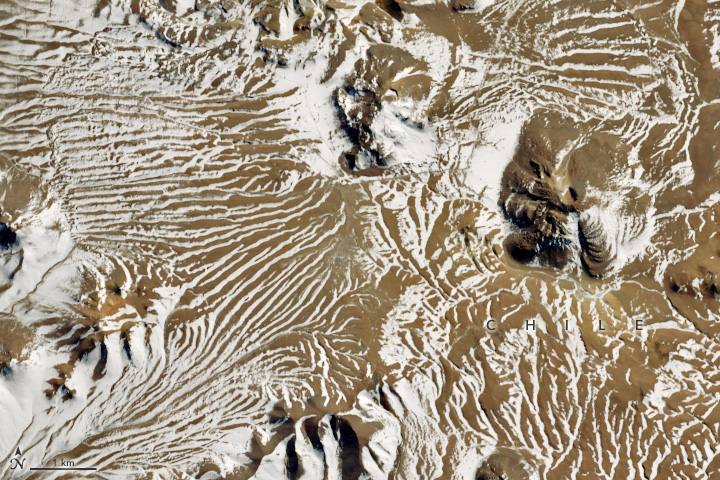
Yet as seen in the images, snow doesn’t typically linger for long, even in this high-elevation region. That’s partly because this area sees some of the highest levels of solar irradiance on Earth, satellite and ground observations show. This dry environment encourages snow loss by fueling sublimation, the transformation of snow directly into a gas. Clear air, high elevation, the presence of certain cloud types, and the Altiplano’s location in the Southern Hemisphere all contribute to the unusually high solar irradiance.
While satellite imagery showed that some snow remained on the ground on July 16, much of it was gone. A live-view camera and posts from researchers visiting ALMA Observatory’s telescopes show that what remained was mostly in low-lying, sheltered areas that are shaded for part of the day.
References & Resources
- ALMA Observatory, via Facebook (2025, June 28) Estamos en El Mercurio: Nieva en zona del desierto de Atacama donde no ocurría hace 12 anos. Accessed July 17, 2025.
- Cordero, R. et al. (2023) Surface Solar Extremes in the Most Irradiated Region on Earth, Altiplano. Bulletin of the American Meteorological Society, E1206-E1221.
- Infobae (2025, June 26) Historic: After more than a decade, the Atacama Desert dawned covered in snow. Accessed July 17, 2025.
- La Tercera (2025, June 26) Desierto de Atacama recibe nieve y observatorio ALMA afirma que fenómeno no se registraba hace más de 10 años. Accessed July 17, 2025.
- Live Science (2025, July 1) Rare snowfall in Atacama Desert forces the world’s most powerful radio telescope into ‘survival mode.’ Accessed July 17, 2025.
- National Radio Astronomy Observatory (2025) ALMA Environmental Specification. Accessed July 17, 2025.
- Reuters (2025, July 1) As Europe sizzles, South America shivers under cold snap. Accessed July 17, 2025.
- World Meteorological Organization (2025, July 3) Southern South America hit by exceptional cold spell. Accessed July 17, 2025.
NASA Earth Observatory images by Wanmei Liang , using Landsat data from the U.S. Geological Survey and MODIS data from NASA EOSDIS LANCE and GIBS/Worldview . Story by Adam Voiland .