


June 29, 2025
Whirling Dust and Ancient Floods
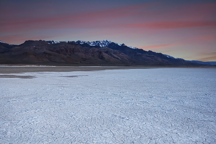
Dust devils are a common sight whirling across the Alvord Desert’s flat expanse. Dry for most of the year, this tract of southeastern Oregon interests scientists seeking to understand the flighty vortices, phenomena that also occur on Mars and potentially elsewhere in our solar system. The playa and its dust stem from the most recent ice age, when a massive pluvial lake covered the area. This lake left the basin covered in bright salt and mineral deposits—and surrounded by evidence of catastrophic flooding.
The images above, acquired with the OLI (Operational Land Imager) on Landsat 8 on June 29, 2025, show the Alvord Desert in false color (left) and natural color (right). The summit of Steens Mountain stands more than a vertical mile above the desert floor to the west, and a steep escarpment borders the playa on the east.
The false-color image (OLI bands 6-5-4) indicates that some water was present in the desert at the time. The basin holds seasonal runoff from Steens Mountain and may also partially fill with rainfall. The last time it was flooded year-round was 1982 through 1985 due to unusually high mountain snowpack, according to the Bureau of Land Management. Alvord Lake, another shallow seasonal lake, is visible farther south.
In recent years, researchers have sought to better understand dust devils by measuring meteorological conditions in the Alvord Desert. The convective vortices are powered by the Sun’s heating of the land surface, but the details of their drivers and inner workings are still somewhat mysterious.
Dust devils are limited to arid areas on Earth but widespread—and sometimes much larger—on Mars. Dust lofted into the Martian atmosphere tends to stay there for a long time and likely plays a significant role in the Martian climate. And while dense atmospheric dust might reduce the available sunlight for powering equipment used to study the planet, forceful dust devil winds can actually play a beneficial role by clearing off solar panels, scientists note.
The Alvord Desert has not always shared these similarities with Mars. During the late Pleistocene epoch, from about 40,000 to 12,000 years ago, Alvord Lake was one of many sprawling lakes filling in basins of the Basin and Range province. Scientists believe the ice-age version of Alvord Lake was over 80 miles (130 kilometers) long and up to 280 feet (85 meters) deep at its highest level.
What’s more, geologists have discovered evidence of at least one catastrophic outburst flood that shaped the landscape for tens of miles downstream. Around 13,000 years ago, the lake breached Big Sand Gap, releasing multiple cubic miles of water into the Coyote Lake basin and ultimately into the Owyhee and Snake Rivers east and north of this scene. Floodwaters carved canyons, scoured bedrock, and deposited boulders up to 100 feet (30 meters) above present-day river channels. Large-scale “fill-and-spill” events such as these shaped the landscape across western North America during this period (for example, in Washington’s Channeled Scablands) due to the presence of many large ice- or debris-dammed lakes.
References & Resources
- Bureau of Land Management Alvord Desert Wilderness Study Area. Accessed July 21, 2025.
- Carter, D.T., et al. (2006) Late Pleistocene outburst flooding from pluvial Lake Alvord into the Owyhee River, Oregon. Geomorphology, 75 (3–4), 346-367.
- Jackson, B., et al. (2018) Using an Instrumented Drone to Probe Dust Devils on Oregon’s Alvord Desert. Remote Sensing, 10(1), 65.
- NASA (2025, April 3) Perseverance Rover Witnesses One Martian Dust Devil Eating Another. Accessed July 21, 2025.
- NASA Earth Observatory (2022, July 27) Dusty Differences Between Mars and Earth. Accessed July 21, 2025.
- Oregon Conservation Strategy (2016) Northern Basin and Range. Accessed July 21, 2025.
- Oregon Public Broadcasting (2025, March 13) The science of dust devils and how it helps understand what’s happening on Mars | Oregon Field Guide. Accessed July 21, 2025.
NASA Earth Observatory images by Michala Garrison, using Landsat data from the U.S. Geological Survey . Photo by Bonnie Moreland . Story by Lindsey Doermann .


