![Request for Information – Potential [Placeholder for Prize]](https://assets.science.nasa.gov/dynamicimage/assets/science/psd/solar/2023/09/s/solarsystem_0.jpg?w=1024)


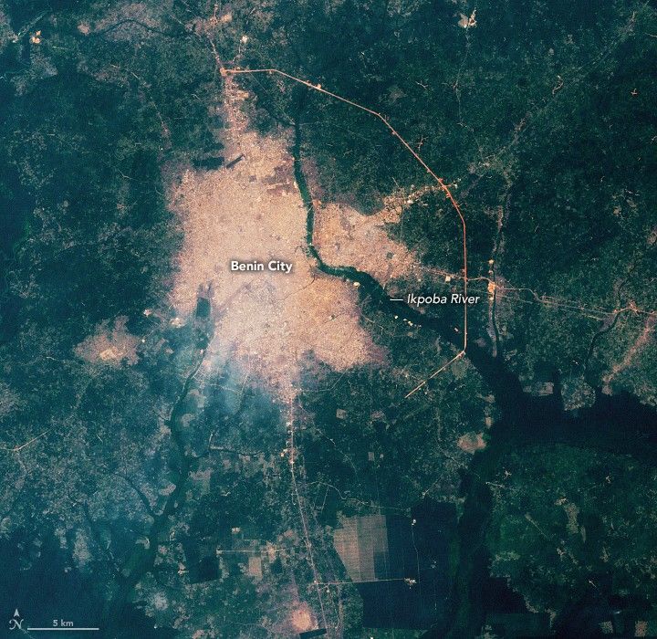


Before and After
January 28, 2002 – January 11, 2025
Home to nearly 240 million people, Nigeria is Africa's most populous country. About twice as many people live there as in Ethiopia, Egypt, the Democratic Republic of the Congo, and Tanzania—the next four largest—and demographers expect the country to grow by another 130 million residents by 2050.
A substantial portion of that growth will occur in Lagos, a megacity of 17 million on the southwestern coast that could become the world's most populous city by 2100, according to some projections. But Nigeria is also home to 85 other "secondary cities" with 100,000 or more people. It's in these smaller cities that urbanization specialists expect to see some of the fastest growth rates in Africa and the world in the coming years, explained Jody Vogeler, a Colorado State University researcher whose lab uses satellites to study urbanization trends in Africa.
Benin City is a textbook example of a rapidly growing secondary city, said Vogeler. The city was once the seat of government for the historical Kingdom of Benin, a precolonial West African state that prospered between the 1200s and 1800s and built some of the world's largest earthworks. In recent decades, as part of Nigeria, the city's population boomed from about 350,000 in 1980 to more than 2 million in 2025.
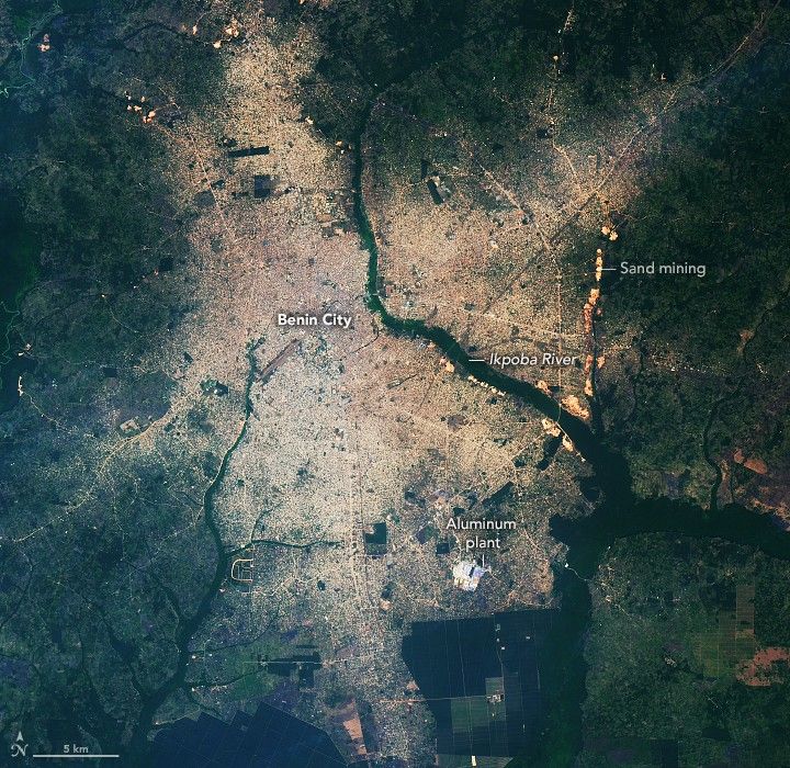
As the population grew, remote sensing experts tracked an accompanying surge in developed land. The ETM+ (Enhanced Thematic Imager Plus) on Landsat 7 captured the image above (left) in 2002, when the population was roughly one million. By the 2020s, the developed land had nearly doubled as vegetated areas in the city declined by more than 650 square kilometers (250 square miles). The OLI-2 (Operational Land Imager-2) on Landsat 9 captured the other image (right) on January 11, 2025.
The darkest green areas surrounding the city are Nigerian lowland forests, a type of rainforest with several hundred tree species and a wide variety of animals. Most of the lighter green areas are agricultural fields, shrublands, or savannas.
Exposed soils in bare areas are red due to the presence of laterite, an iron- and aluminum-rich soil and rock type. Exposure to air and water turns the material red as it becomes rich in the mineral hematite. The bright linear feature is a new section of road; engineers often use laterite soils when constructing roads, leading to especially red roadways in the first few years after roads are installed.
Like many Nigerian cities, Benin City experienced rapid rural-to-urban migration as economic opportunities proliferated in urban areas and stagnated in rural ones. Expansions of the education, public, manufacturing, mining, and transportation sectors contributed to the city’s growth. For instance, the city hosts the University of Benin with tens of thousands of students, serves as the seat of government for Edo state, and functions as a production hub for sand, rubber, and aluminum.
Landsat's long record has helped scientists track more than the city's expansion. Over the past 25 years, researchers have used Landsat observations to measure the city's urban heat island, assess topographic changes due to erosion and urbanization, and gauge flood risks across the city.
Satellites, including Landsat, are also helping researchers map and better understand the distribution of the city's informal settlements—unplanned settlements with small buildings on irregularly shaped blocks that have sprung up on the outskirts of the city. Residents in such areas often lack access to basic services such as water, sanitation, and electricity, said Vogeler.
By one estimate, about 45 percent of Nigeria's urban population lives in informal settlements. To help map communities like these, the University of Chicago’s Million Neighborhoods mapping project—based in part on Landsat data from the Global Human Settlement Layer—combines a broad range of data to identify underserved areas in Nigeria and across Africa that lack access to roads and other infrastructure.
Meanwhile, Vogeler is particularly proud of her lab’s new automated technique for delineating the city boundary that goes beyond the simple administrative boundary to include clusters of development—both planned and unplanned—that are functionally part of the city but were previously excluded.
The lab has developed land-cover maps for Benin City and other cities in Ethiopia, Nigeria, and South Africa to help city managers, urban planners, and researchers better understand how these cities are changing over time. According to Vogeler, the maps are tailored to support specific sustainable development goals established by the United Nations.
NASA Earth Observatory images by Lauren Dauphin, using Landsat data from the U.S. Geological Survey. Story by Adam Voiland.
References & Resources
- Agheyisi, J.E. & Aghedo, I. (2021) Neighborhood Vulnerability to Security Threats in Benin City: The Role of Informal Housing and the Built Environment. African Studies Quarterly, 20(4).
- Heydari, S.S. (2024) Multi-Tier Land Use and Land Cover Mapping Framework and Its Application in Urbanization Analysis in Three African Countries. Remote Sensing, 16(14), 2677.
- Laituri, M., et al. (2025) The last urban frontier—assessing hotspots of urban change associated with LCLUC in Africa. Frontiers in Sustainable Cities, 27, 7.
- NASA (2022) ARSET - Earth Observations Toolkit for Sustainable Cities and Human Settlements. Accessed December 1, 2025.
- Odeyale, T.O. (2023) Reflections on the Impact of Urban Sprawl on the Architecture of the City: Lessons from Benin City, Nigeria. Forum Geografi, 37(1).
- Ojo, P.E. & Okonofua, E.S. (2024) A Comprehensive Evaluation of Urbanization Impact on Land Cover in Benin City. Journal of Energy Technology and Environment, 6(2).
- Vogeler Lab (2025) Assessing drivers of urbanization and tradeoffs among social and ecosystem services associated with LCLUC in Africa. Accessed December 1, 2025.