


![Request for Information – Potential [Placeholder for Prize]](https://assets.science.nasa.gov/dynamicimage/assets/science/missions/a-step/FFR_Earth_Background_20251120%20.png?w=1024)


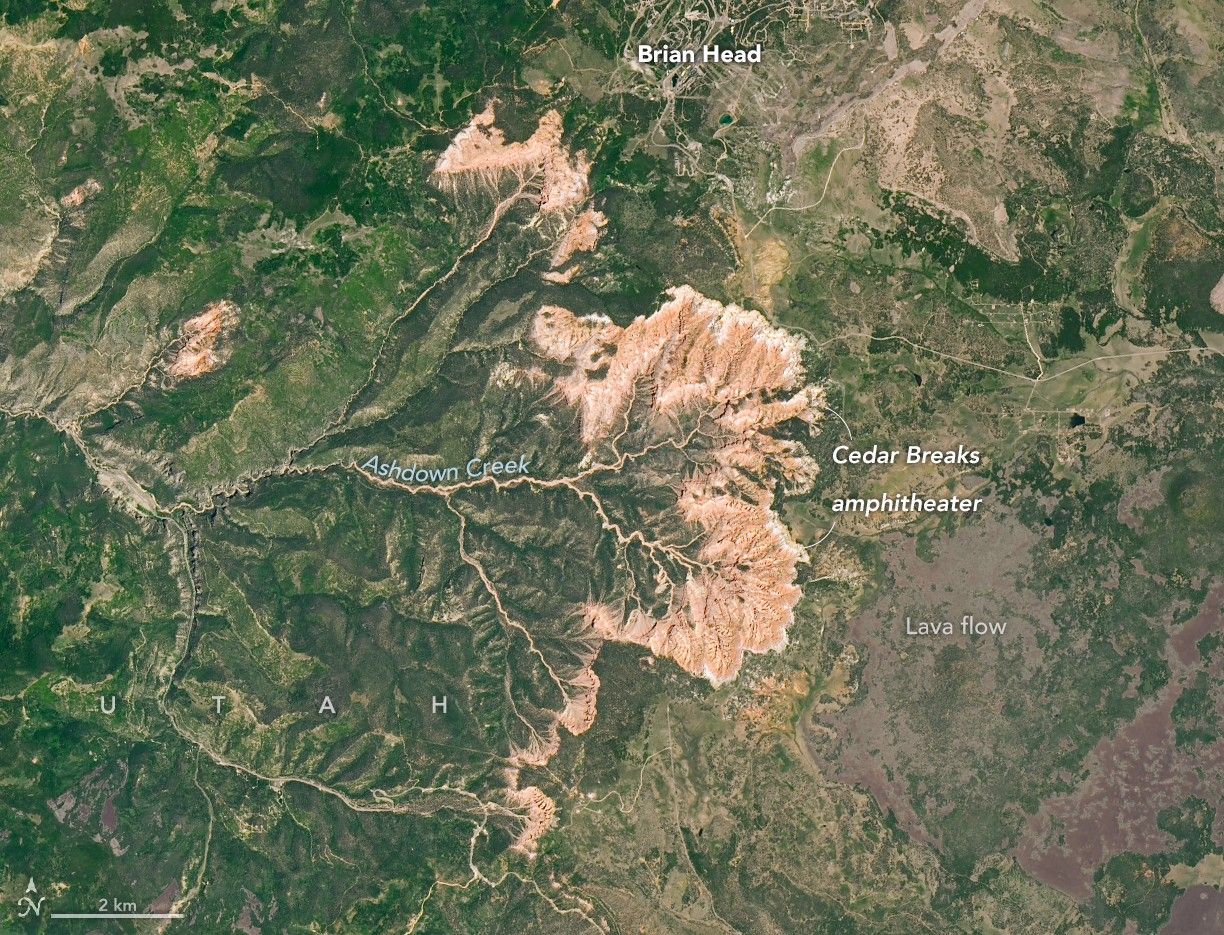
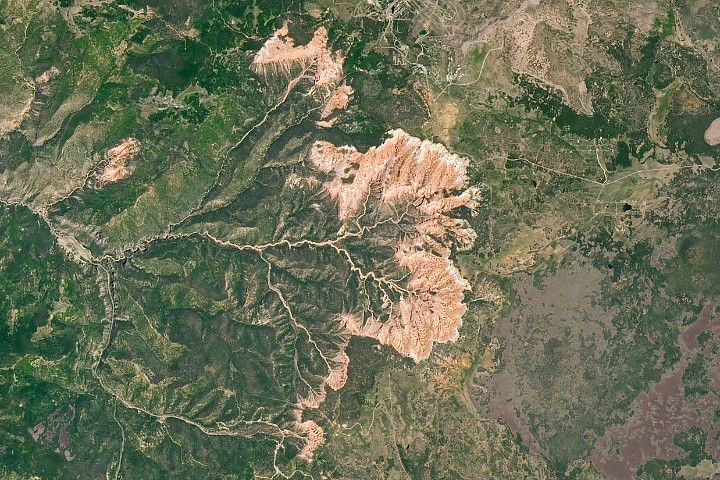
When people stand at the rim of the amphitheater in Utah's Cedar Breaks National Monument and look down on an otherworldly landscape of multicolored rock spires, pinnacles, and other geologic oddities, they're looking across tens of millions of years of Earth's history. The same can be said when viewing the bowl-shaped escarpment from space.
The OLI-2 (Operational Land Imager-2) on Landsat 9 captured this view of the amphitheater's semicircular rim and deeply eroded drainages on June 18, 2025. The erosive power of water from Ashdown Creek and several tributaries, along with relentless physical and chemical weathering, is evident in the many channels, cliffs, and canyons that radiate outward from the rim and define the escarpment and amphitheater.
The feature's striking rock formations are composed of sedimentary rock layers laid down roughly 50 to 25 million years ago within a basin that, at times, held a large body of water called Lake Claron. Many of the amphitheater's limestone layers began as sediments that settled on its lakebed as carbonate-rich muds.
Differences in rock type and color, evident in the layering seen in ground photographs and to a degree in Landsat images, reflect differences in environmental conditions during deposition. Lake Claron, for instance, was sometimes quite deep, but during dry periods it was shallow or nonexistent. In wet conditions, iron in muddy sediments was scarce or had too little exposure to oxygen to oxidize, or rust, leaving the resulting rock white or gray. During drier periods, iron in sediments had greater exposure to oxygen, forming minerals that turned layers red and orange.
After deposition, slow-moving tectonic forces lifted all these rock layers upward, ultimately putting them at the top of the Grand Staircase—an immense sedimentary sequence that stretches south from Cedar Breaks and Bryce Canyon, through Grand Staircase-Escalante National Monument and Zion Canyon, and finally into the Grand Canyon. Younger rock layers are found at the top of the sequence and older layers at the bottom.
The rim at Cedar Breaks, the top of the staircase, sits about 10,000 feet (3,000 meters) above sea level, roughly 7,000 feet above the Colorado River in the Grand Canyon. The high elevation influences everything from the weather to the plants and animals that live there. Winters are long, cold, and snowy, with nearby Brian Head seeing 30 feet (10 meters) of snowfall each year on average.
While the cool temperatures and short growing season are an impediment to many types of vegetation, the slow-growing and notoriously long-lived bristlecone pines found along the escarpment's rim use the harsh conditions to their advantage. Slow growth makes their wood unusually dense, which protects the trees from disease and insects. Likewise, their ability to survive in thin soils, on mostly barren limestone outcrops where little else can grow, protects them from wildfires. Some of the oldest bristlecones in the monument are more than 1,700 years old.
Sitting atop the sedimentary layers, signs of a more volcanically active period also appear in the image. The dark basaltic lava flows visible to the east of the amphitheater formed between 5 million and 10,000 years ago, when several volcanoes on the Markagunt Plateau erupted regularly. Areas of soft, gray rock around the summit of Brian Head—now the site of a ski resort—formed when pyroclastic flows left deposits of tuff strewn across the landscape.
NASA Earth Observatory images by Michala Garrison, using Landsat data from the U.S. Geological Survey. Story by Adam Voiland.
References & Resources
- Cedar Breaks National Monument Bristlecone Pines. Accessed December 18, 2025.
- Global Volcanism Program (2013) Markagunt Plateau. Accessed December 18, 2025.
- NASA Earth Observatory (2025) U.S. National Parks from Space. Accessed December 18, 2025.
- National Park Service (2025) Cedar Breaks National Monument. Accessed December 18, 2025.
- National Park Service (2025) Grand Staircase. Accessed December 18, 2025.
- National Park Service (2006) Cedar Breaks National Monument Geologic Resource Evaluation Report. Accessed December 18, 2025.
- Zion Natural History Association, via Internet Archive (1985) Geologic Cross Section of the Cedar Breaks-Zion-Grand Canyon Region. Accessed December 18, 2025.


