


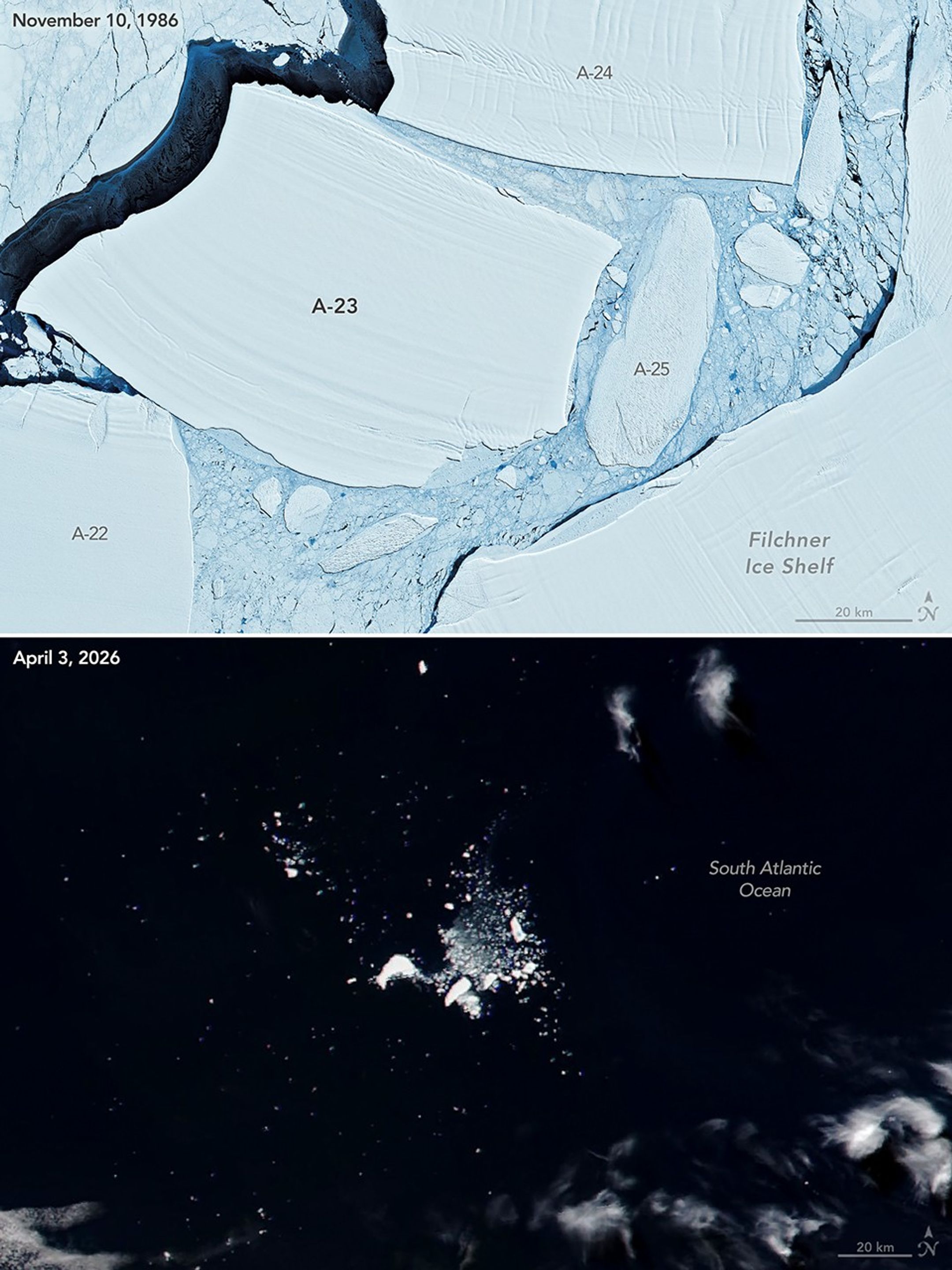
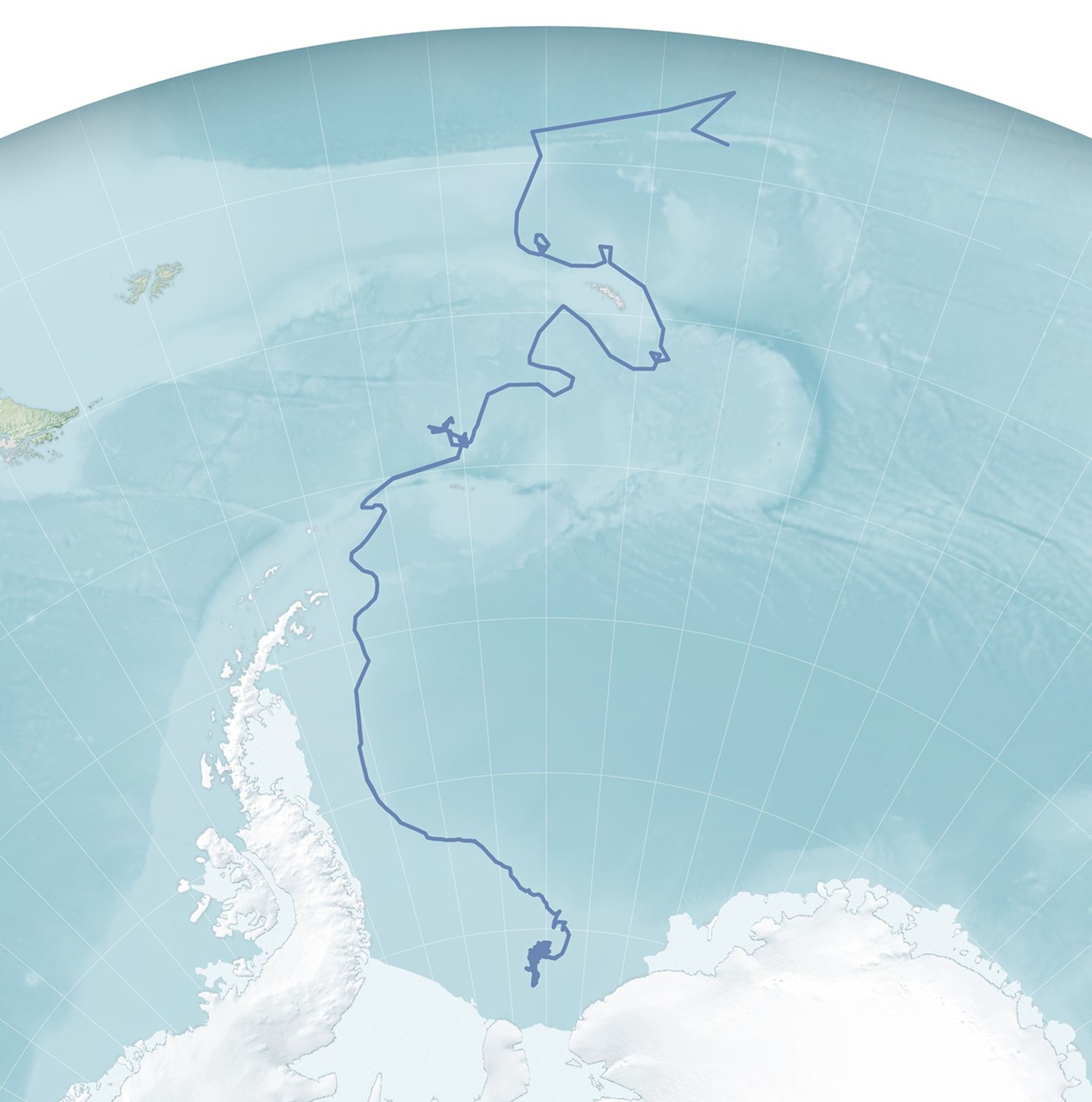
Iceberg A-23A ranks among the giants known to have broken, or “calved,” from Antarctica. Though several other icebergs in the satellite era have been larger, A-23A was remarkable for its longevity. After spending its early days in the Weddell Sea, its journey came to an end in the South Atlantic Ocean, months shy of its 40th birthday.
These images show the iceberg at the start and end of its lifespan. The MSS (Multispectral Scanner System) on Landsat 5 captured the top image on November 10, 1986, shortly after Iceberg A-23 broke from the Filchner Ice Shelf. (The main section was later renamed A-23A after a smaller piece split off.) It is pictured here with several other major icebergs from the same calving event. A-23A outlived all of them.
The second image, captured by the VIIRS (Visible Infrared Imaging Radiometer Suite) on the NOAA-21 satellite on April 3, 2026, shows what remained of the iceberg at the end of its journey. By this point, the ice had drifted into warmer waters north of South Georgia and the South Sandwich Islands—more than 2,300 kilometers (2,000 miles) north of where the iceberg first calved.
Drifting Toward Disintegration
Iceberg A-23A’s final months brought abundant drift, melt, and breakage. It exited the U.S. National Ice Center’s area of analysis during the week of February 6, 2026, and was transferred to the jurisdiction of the Argentinian Meteorological Service as it drifted into maritime traffic lanes, according to the center’s ice analysts.
Jan Lieser of Australia’s Bureau of Meteorology and Christopher Shuman of the University of Maryland (retired) have long been tracking the iceberg with remote sensing. They estimated that by March 27, 2026, A-23A had shrunk to just over 170 square kilometers (66 square miles)—a small fraction of the more than 6,000 square kilometers (2,300 square miles) it spanned in 2020 as it lay grounded off the Antarctic coast. Large pools of deep-blue meltwater collected on its surface and likely contributed to its ultimate collapse, visible on March 31.
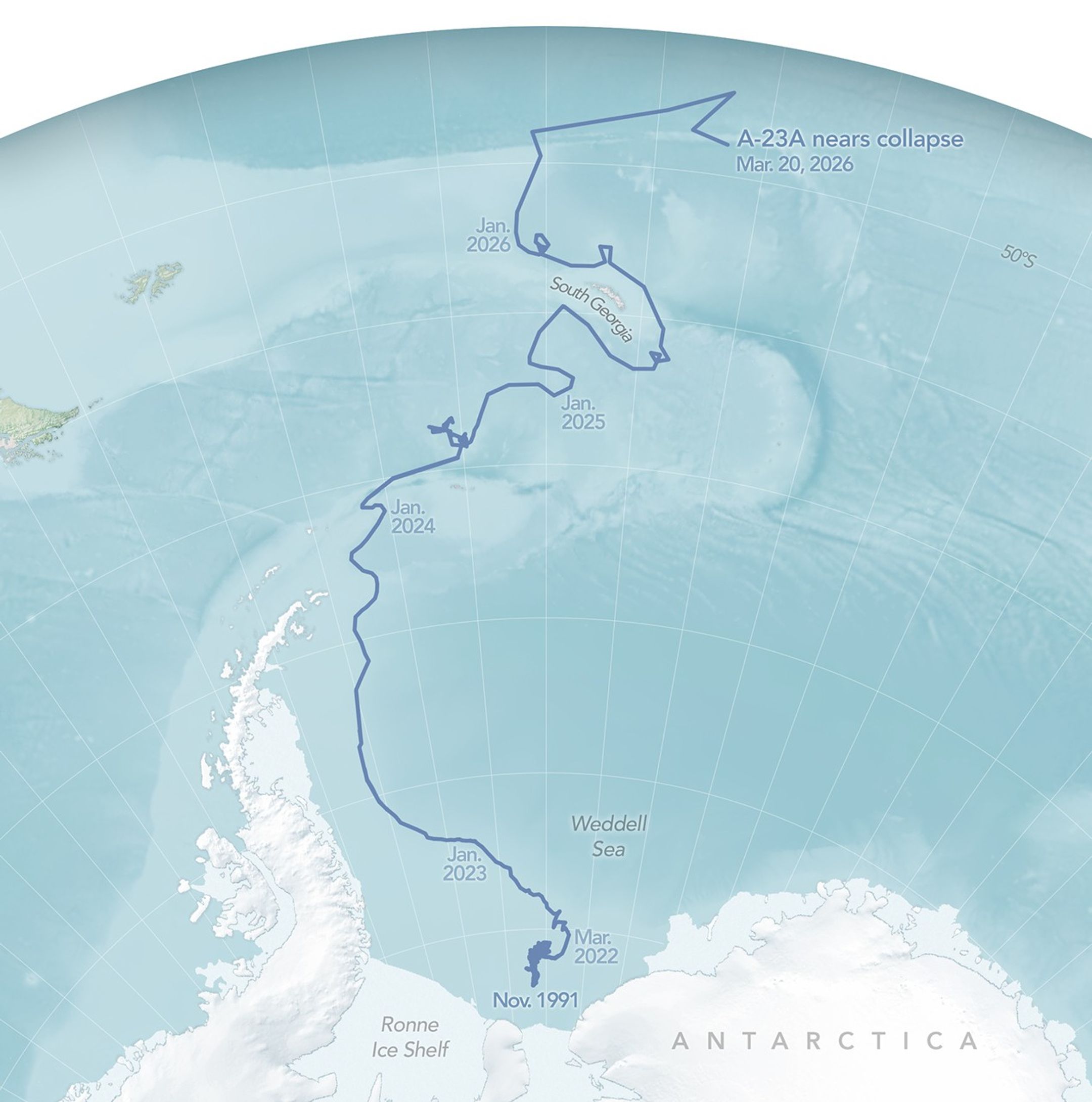
Clouds obscured some satellite observations of the berg’s final days. “I noticed in recent weeks how Mother Nature seemed to keep a veil (of clouds) over the dying iceberg as if trying to give it some privacy at this stage,” Lieser said. There were still enough observations, however, to capture glimpses of its death throes, as well as the many stages of its long, winding journey.
Tracking A-23A Across the Satellite Era
Iceberg A-23A “came of age” during a period of advances in Earth observation. The Landsat program, ongoing since the early 1970s, captured detailed images throughout the iceberg’s life, while the Terra and Aqua satellites—imaging Earth since the early 2000s—offered broader, daily snapshots as sunlight and clouds allowed.
By the time A-23A broke free from the seafloor in 2022 and began drifting north, a vastly expanded fleet of missions was available to observe its journey—capturing everything from detailed images of its shifting shape to its effects on the surrounding environment. Astronauts aboard the International Space Station added their own close-up perspective, while the newer PACE satellite identified the iceberg’s ripple effects on marine ecosystems. The video below brings together some of NASA’s most striking views of the drifting giant’s journey.
“The technology that allows us to tell ‘iceberg stories’ is a tribute to the engineers and funding that put crucial sensors into orbit to collect those data and make them accessible,” Shuman said. “Through time, these efforts have allowed us to understand the general patterns of iceberg movement around Antarctica, especially in the last handful of decades.”
Lingering Mysteries of Iceberg Motion
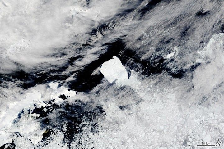
With all the images and data that A-23A and other bergs have left behind, scientists now have even more questions about the factors driving iceberg motion, from ocean currents to the shape of the seafloor. Lieser is particularly interested in the small- to medium-sized bergs that break from the giants, as they pose significant hazards to shipping. These smaller bergs, such as the trail near A-23A on March 1, are also notoriously difficult to track, as well as to model in terms of their expected drift.
The megabergs generated by Antarctica’s vast ice shelves also still carry plenty of mystery. In the case of A-23A, Lieser and Shuman wonder what the bathymetry looks like where it became stuck shortly after calving in 1986 and how the iceberg later became ensnared by a rotating vortex of water, or Taylor column, north of the South Orkney Islands.
“We certainly do know a fair bit about the general drift patterns of icebergs and the general environment,” Lieser said. “But when it comes to individual pieces—large and small—and their tracks, there's still a fair bit to learn.”
NASA Earth Observatory images by Michala Garrison, using Landsat data from the U.S. Geological Survey, VIIRS data from NASA EOSDIS LANCE, GIBS/Worldview, and the Joint Polar Satellite System (JPSS). Map made using data from the U.S. National Ice Center (USNIC) and the Antarctic Iceberg Tracking Database (BYU). Earth Observatory video by Kathryn Hansen, featuring imagery from sources listed under References & Resources. Story by Kathryn Hansen.

References & Resources
- NASA Earth Observatory (2026, March 6) Ailing “Megaberg” Sparks Surge of Microscopic Life. Accessed April 10, 2026.
- NASA Earth Observatory (2026, January 8) Meltwater Turns Iceberg A-23A Blue. Accessed April 10, 2026.
- NASA Earth Observatory (2025, September 25) A Giant Iceberg’s Final Drift. Accessed April 10, 2026.
- NASA Earth Observatory (2025, August 2) Antarctic Iceberg Downsizes. Accessed April 10, 2026.
- NASA Earth Observatory (2025, May 7) Antarctic Iceberg Loses Its Edge. Accessed April 10, 2026.
- NASA Earth Observatory (2025, March 7) Iceberg Grinds to a Stop off South Georgia Island. Accessed April 10, 2026.
- NASA Earth Observatory (2024, December 20) Antarctic Iceberg Spins Out. Accessed April 10, 2026.
- NASA Earth Observatory (2023, December 1) Antarctic Iceberg Sails Away. Accessed April 10, 2026.
- NASA Earth Observatory (2022, March 19) March of the Icebergs. Accessed April 10, 2026.
- NASA Earth Observatory (2010, January 15) Rapid Sea Ice Breakup along the Ronne-Filchner Ice Shelf. Accessed April 10, 2026.


