


![Request for Information – Potential [Placeholder for Prize]](https://assets.science.nasa.gov/dynamicimage/assets/science/psd/solar/2023/09/s/solarsystem_0.jpg?w=1024)


Description
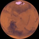
Center of the orthographic projection is at latitude 30 degrees N., longitude 270 degrees. The north polar residual ice cap of the Planum Boreum region, which is cut by spiral-patterned troughs, is located at top. The upper part is marked by a large depression, Isidis basin, which contains light-colored plains. The upper part also includes the light-colored smooth plains of Elysium Planitia and dark plains of Vastitas Borealis. Together, these form a vast expanse of contiguous plains. Toward the bottom, on the other hand, the southern hemisphere is almost entirely made up of heavily cratered highlands. At bottom left, a conspicuous, relatively bright circular depression marks the ancient large Hellas impact basin.


