About NASA’s Earth Science Division
NASA applies ingenuity and expertise gained from decades of planetary and deep-space exploration to the study of our home planet. The Earth Science Division operates more than 20 satellites in orbit, sponsors hundreds of research programs and studies, and funds opportunities to put data to use for societal needs. We develop new ways to observe the oceans, land cover, ice, atmosphere, and life, and we measure how changes in one drive changes in others over the short and long term. While listening to and collaborating with industry leaders, international partners, academic institutions, and other users of our data, we deepen knowledge of our planet, drive innovations, and deliver science to help inform decisions that benefit the nation and the world.
The five elements of NASA’s Earth Science Division (ESD) ― Earth Science Technology Office (ESTO), Flight, Earth Science Data Systems (ESDS), Earth System Science Research Program (ESSRP), and Earth Action ― work together from mission concept to conclusion to both enhance existing Earth observations and find new ways to analyze our living planet.
Division Leadership
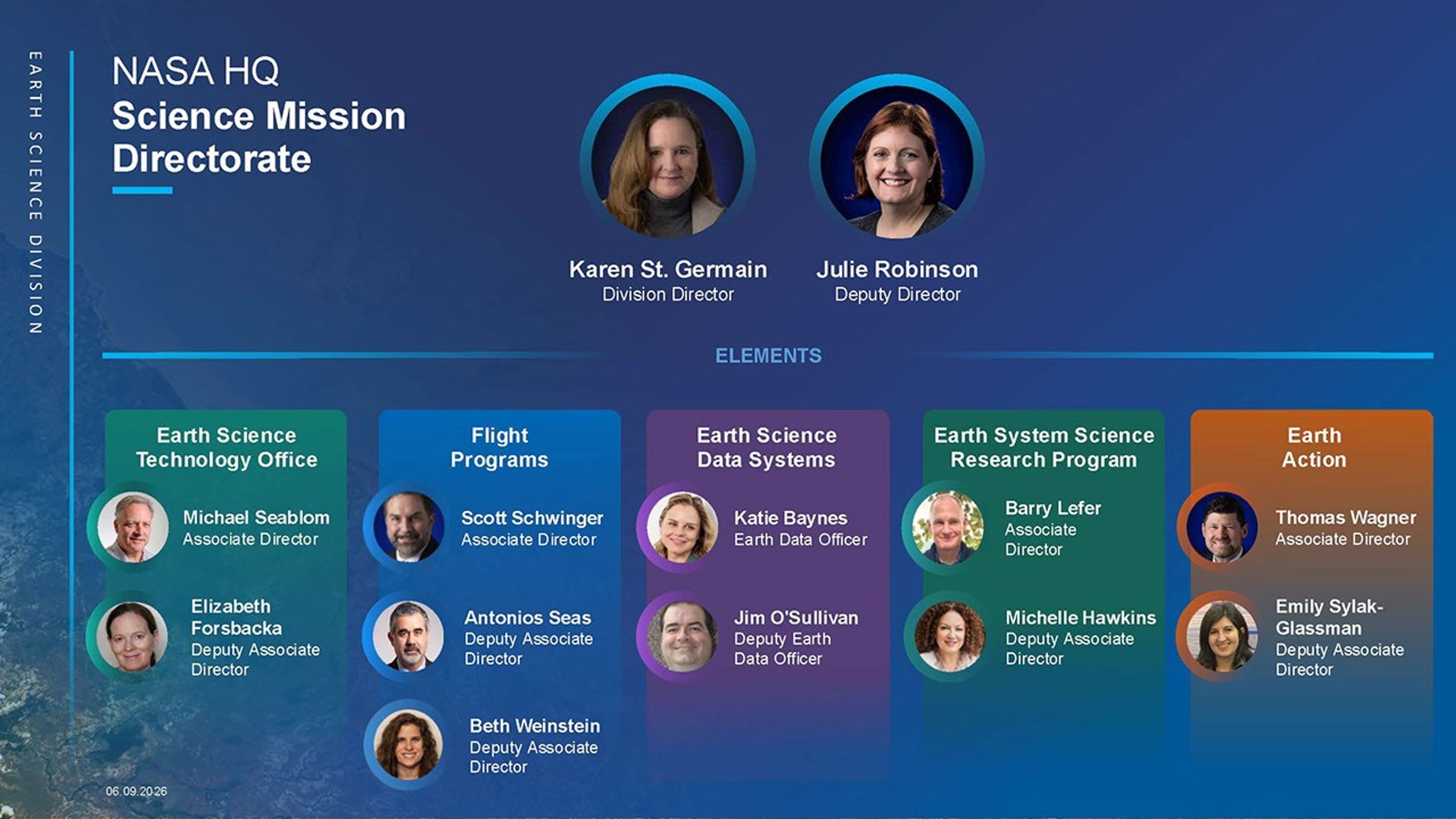
- Dr. Karen St. Germain - Division Director
- Dr. Julie Robinson - Deputy Director
- Earth Science Technology Office (ESTO)
- Michael Seablom, Associate Director
- Elizabeth Forsbacka, Deputy Associate Director
- Flight
- Scott Schwinger, Associate Director
- Antonios Seas, Deputy Associate Director
- Beth Weinstein, Deputy Associate Director
- Earth Science Data Systems (ESDS)
- Katie Baynes, Earth Data Officer
- Jim O'Sullivan, Deputy Earth Data Officer
- Earth System Science Research Program (ESSRP)
- Earth Action
Earth Science Division Elements
-
Earth Science Technology Office (ESTO)
The Earth Science Technology Office (ESTO) provides grants and support for cutting-edge sensors, information systems, and a variety of other projects to develop breakthrough technologies that can improve Earth observations. We believe that diverse ideas from engineers, scientists, and students nationwide will deepen our knowledge of Earth’s systems and help guide decision makers.
-
Flight
The Flight team builds and operates the satellite and airborne missions that deliver critical measurements and data to the world’s science community.
-
Earth Science Data Systems (ESDS)
NASA’s Earth Science Data Systems (ESDS) Program oversees the entire Earth science data life cycle and facilitates unrestricted access to the data researchers, managers, and governments need to understand and protect our planet.
-
Earth System Science Research Program (ESSRP)
ESSRP advances Earth system science by enabling the use of satellite, airborne, and ground-based observations, along with modeling approaches, to improve understanding of Earth processes. In collaboration with domestic and international partners, ESSRP ensures that findings inform NASA missions, are published in peer-reviewed literature, and are shared with the broader scientific community and public.
-
Earth Action
Earth Action promotes the use of NASA Earth science data to inform crucial decision-making, enhance quality of life, and strengthen our economy. Earth Action also listens to and works with potential data users, developing tools and resources for them to easily access Earth science data.