


September 16-October 2, 2023
A Smoky Pall Over Canada
Wildland fires burn through Canada’s boreal forests every summer as temperatures rise and lightning ignites blazes. Widespread fire activity typically begins to taper off in late-August and fades away by October as days shorten, temperatures cool, and fall weather patterns take control.
Not in 2023. Fires that had been burning in western Canada for months continued to rage furiously into October, growing at some of the fastest rates they have all year and generating record amounts of emissions. Evidence of their intensity filled North American skies in the last two weeks of September, with expansive smoke plumes swirling across much of Canada.
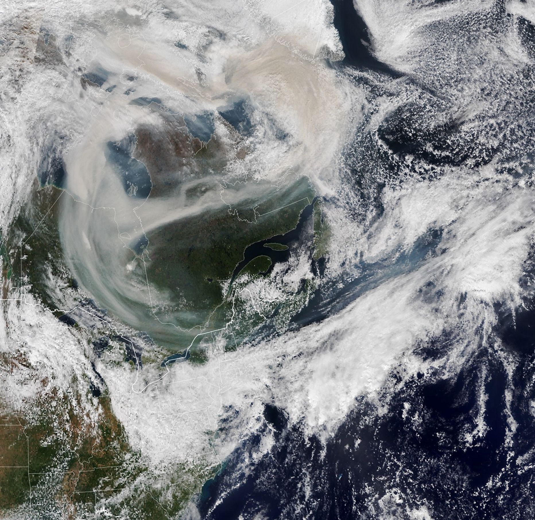
The image above (right)—acquired by the Visible Infrared Imaging Radiometer Suite (VIIRS) on NOAA-20 on October 1, 2023—shows a long smoke plume extending along the U.S. East Coast. NASA atmospheric scientist Gary Partyka described the pattern as “highly indexed meridional flow” that drew smoke in a circuitous route around Canada and into the United States, rather than carrying it generally west to east at higher latitudes, as is more typical.
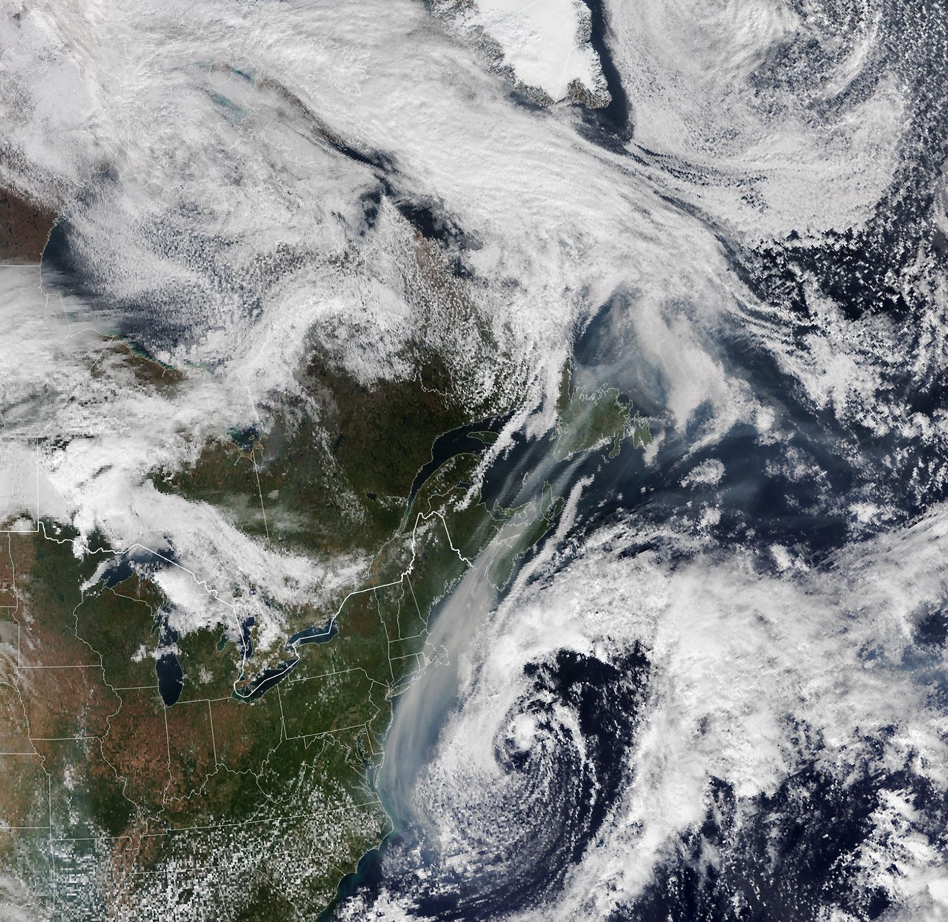
The smoke over the eastern U.S. originated thousands of miles away in western Canada, added Partyka, who tracked its movement using the GEOS forward processing (GEOS-FP) model developed by NASA’s Global Modeling and Assimilation Office. VIIRS acquired the other image (left) of smoke streaming over eastern Canada on September 25, 2023. Meteorologists with The Washington Post reported that part of the reason that smoke dipped so far south was that winds had to steer the smoke around a sprawling zone of high pressure over central North America known as an omega block.
The animation above highlights the density of black carbon particles—commonly called soot—in the smoke as it moved across North America between September 16 and October 2. The GEOS-FP model assimilates data from satellite, aircraft, and ground-based observing systems to depict the plume's movement. In addition to making use of satellite observations of aerosols and fires, GEOS-FP incorporates meteorological data like air temperature, moisture, and winds.
Of the 447 fires that were active across Canada on September 15, nearly half were classified as out of control, according to the Canadian Interagency Forest Fire Centre (CIFFC). On September 27, the last day that CIFFC reported numbers for the year, those numbers remained remarkably high. Of the 798 fires burning on that date, 382 were out of control.
Particularly intense burning on September 15 and 22 in British Columbia and Alberta fueled several pyrocumulunimbus clouds (pyroCbs) that lofted smoke high in the atmosphere, where fast-moving, upper-level winds then spread it widely. In the absence of pyroCbs, the smoke would have remained closer to the surface, nearer to the fires that produced it, and less visible in satellite imagery.
While the influx of smoke was noticeable in New York City and other major cities along the eastern seaboard, the impact on air quality was modest because the smoke was relatively high. In June 2023, a major intrusion of surface-level smoke from fires in Quebec darkened skies in the same region and triggered more severe air quality problems.
References & Resources
- Canadian Interagency Forest Fire Centre (2023) Situation Reports. Accessed October 3, 2023.
- NASA Earth Observatory (2023, June 9) Hazardous Air Chokes Northeastern States. Accessed October 3, 2023.
- Parrington, M. via X (2023, September 27) Late September increase... Accessed October 3, 2023.
- The Washington Post (2023, October 3) Wildfire smoke from Canada invades East Coast as far south as Florida. Accessed October 3, 2023.
- The Washington Post (2023, September 25) Canada’s unprecedented fire season burns into fall. Accessed October 3, 2023.
- The Weather Channel (2023, September 27) Canada Wildfire Smoke Crossed The Atlantic Ocean...In September. Accessed October 3, 2023.
- AFP via Yahoo (2023, October 23) Canada left battered by ‘never before seen’ wildfire season. Accessed October 3, 2023.
NASA Earth Observatory images by Lauren Dauphin, using GEOS data from the Global Modeling and Assimilation Office at NASA GSFC and VIIRS data from NASA EOSDIS LANCE , GIBS/Worldview , and the Joint Polar Satellite System (JPSS). Story by Adam Voiland .