


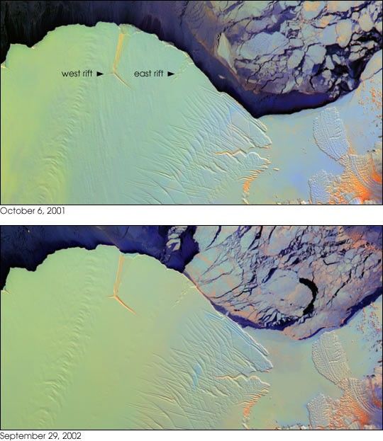
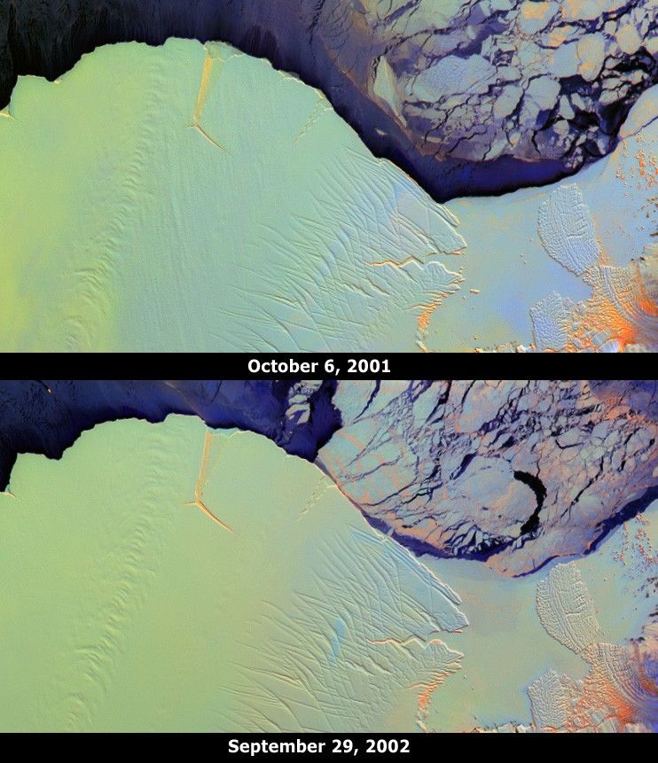
The Amery Ice Shelf is an important dynamic system responsible fordraining about 16 percent of the grounded East Antarctic ice sheet through only2 percent of its coastline. Most of the mass input to the system occurs fromthe Lambert Glacier and several other glaciers. Mass loss from the system occursthrough basal melting and iceberg calving. These images from theMulti-angle Imaging SpectroRadiometer (MISR) portray the ice shelf fronton October 6, 2001 (top), and September 29, 2002 (bottom), and illustratechanges that took place over the year elapsed between the two views.
Two longitudinal rifts, oriented roughly parallel to the direction ofice flow and measuring about 25 and 15 kilometers in length, areapparent near the seaward edge of the ice shelf. Between them, atransverse fracture extends eastward from the base of the western rift.This rift system is colloquially named the Amery “loose tooth.” Over thecourse of the one-year interval between these two MISR images, the icefront has advanced approximately 1.6 - 1.7 kilometers, and thetransverse fracture and a three-way fissure at the juncture of the riftshave widened. When the transverse fracture eventually reaches theeastern rift, a large iceberg (25 kilometers x 25 kilometers) will be released.
These false-color multi-angle composites combine red-band data fromMISR’s 60-degree forward, nadir, and 60-degree aftward viewing cameras, displayed asred, green, and blue, respectively. Different colors represent angular reflectance variations. Since generally smooth surfaces predominantly forward-scatter sunlight, these surfaces appear in shades of blue. Rough surfaces tend to backward-scatter sunlight, and these surfaces appear in shades of red ororange. Low clouds appear bright purple, since they exhibit both forward and backward scattering. Using this technique, textural variations among ice types are revealed, and clouds can be easily distinguished from ice.Illumination conditions on the two dates are nearly identical.
Understanding the “normal” frequency of calving events from a particularice shelf is necessary before it can be determined whether calving ratesare changing. As part of an effort to determine the normal rate of iceflow and iceberg calving events, the Amery Ice Shelf front has been monitored by various remote-sensing instruments for many years. TheAmery Ice Shelf is currently considered to be about two-thirds of the way through a calving cycle. The last major calving event occurred inthe early 1960s, when a massive iceberg (measuring about 140 kilometers x 70 kilometers) was released.
The Amery “loose tooth” is the subject of a joint field experimentduring the 2002 austral summer, partially funded by NASA and undertaken by the Scripps Institution of Oceanography and the Australian Antarctic Division. The Multi-angle Imaging SpectroRadiometer observes the daylitEarth continuously from pole to pole, and every nine days views the entireglobe between 82 degrees north and 82 degrees south latitude. TheMISR Browse Image Viewer provides access to low-resolution true-color versions of these images. These dataproducts were generated from a portion of the imagery acquired during Terra orbits 9579 and 14807. The panels cover an area of about 204 kilometers x 110 kilometers, and utilize data from blocks 146 to 147within World Reference System-2 paths 127 and 128, respectively. Datafrom the two orbital paths have been remapped to identical polarprojections, and were cropped to include the same geographic area.
References & Resources
Image courtesy NASA/GSFC/LaRC/JPL, MISR Team Text by Clare Averill, David J. Diner (Jet Propulsion Laboratory), and Helen A. Fricker (Scripps Institution of Oceanography).


