


Within the span of a week, powerful back-to-back typhoons pummeled the Philippines in October. First, Typhoon Sarika made landfall over Luzon on October 15, 2016. Then Typhoon Haima hit the island four days later.
Both storms are visible in this image, acquired October 18, 2016, with the Visible Infrared Imaging Radiometer Suite (VIIRS) on the Suomi NPP satellite. The image is comprised of two natural-color scenes, acquired about 40 minutes apart, that have been stitched together to form a seamless image. At the time, Haima was a category 4 super typhoon with top sustained winds of about 240 kilometers (150 miles) per hour. The storm was about 900 kilometers (600 miles) from Luzon and approaching from the east.
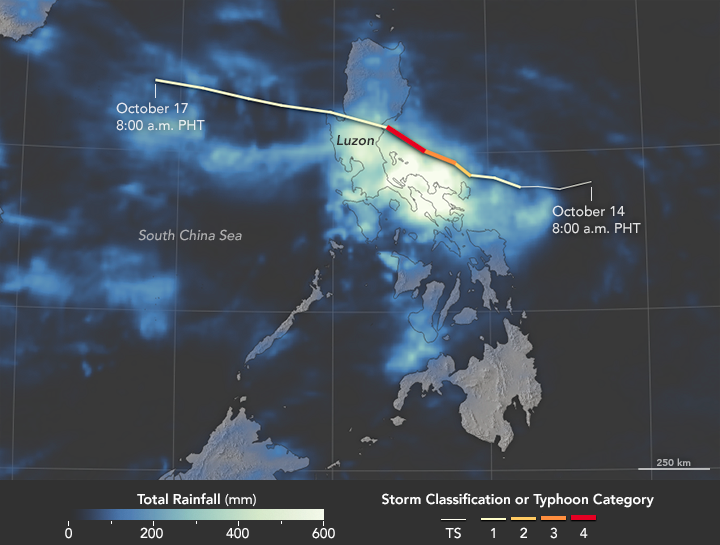
Before Haima made landfall in northern Luzon, soils were already saturated by the deluge previously delivered by Typhoon Sarika. This map illustrates the scenario, depicting satellite-based measurements of rainfall from October 14-17, 2016. Sarika’s storm track is overlaid on the map. The rainfall totals are regional, remotely-sensed estimates, and local amounts can be significantly higher when measured from the ground. According to news reports, some towns saw about 550 millimeters (22 inches) of rain on October 14 and 15.
“It’s likely that Haima will cause slides in both the Philippines and China,” said Thomas Stanley, a geoscientist at NASA’s Goddard Space Flight Center who catalogs rainfall-triggered landslides. He points out that a number of landslides, presumably due to Sarika, have already been reported, including a deadly event in southwestern Luzon.
Haima strengthened into a category 5 storm and then weakened slightly as it started to interact with Luzon’s mountainous terrain on October 19. According to relief agencies, food supplies could be threatened as central Luzon is where most of the country’s rice is grown. More immediately, thousands of families have been displaced.
References & Resources
- Reliefweb (2016, October 19) Singapore Red Cross’ humanitarian response to typhoons in Philippines and Vietnam. Accessed October 19, 2016.
- Unisys Weather (2016, October 19) Typhoon-4 SARIKA. Accessed October 19, 2016.
- Unisys Weather (2016, October 19) Typhoon-5 HAIMA. Accessed October 19, 2016.
- The Weather Channel (2016, October 19) Typhoon Haima (Lawin) Makes Landfall in the Northern Philippines With 140 MPH Winds. Accessed October 19, 2016.
- Weather Underground’s WunderBlog (2016, October 18) Sarika Weakens to a Tropical Storm, Poses Flood Threat to China and Vietnam. Accessed October 19, 2016.
NASA Earth Observatory images by Joshua Stevens and Jesse Allen, using IMERG data provided courtesy of the Global Precipitation Mission (GPM) Science Team’s Precipitation Processing System (PPS) and VIIRS data from the Suomi National Polar-orbiting Partnership . Suomi NPP is the result of a partnership between NASA, the National Oceanic and Atmospheric Administration, and the Department of Defense. Caption by Kathryn Hansen.


