


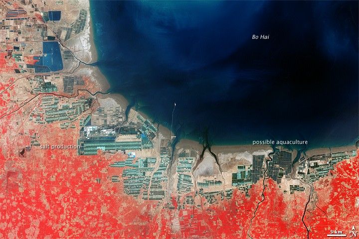
The final decades of the twentieth century brought rapid development to eastern China’s Bo Hai coast, where the nearby sea supported both salt production and aquaculture.
The Multispectral Scanner on NASA’s Landsat 3 satellite acquired the top image on May 27, 1979. The Enhanced Thematic Mapper Plus on NASA’s Landsat 7 satellite acquired the bottom image on May 2, 2000. Both images are false-color, where red indicates vegetation, dark blue indicates deep water, aquamarine indicates shallow water, and beige and deep brown indicate bare ground or sand.
Developed areas appear in both images as grids of straight lines and sharp angles. In the 1979 image, isolated industrialized areas appear scattered along the coast, the largest appearing where the coast curves northward. In the 2000 image, developed areas have swallowed up most of the coastline, with blue, aquamarine, and off-white rectangles replacing what was previously bare ground.
Some of the development in this area produced salt. The production of sea salt generally involves drawing salty water into a series of reservoirs where the water slowly evaporates, forming concentrated brine, and finally crystallizing. The networks of reservoirs in this image that are filled with progressively lighter liquid likely result from such a salt production process. The 2008 discovery of an ancient salt works some 10 kilometers (6 miles) from the Bo Hai coast in China’s Shandong Province attests to the region’s long history in salt making.
Other developed areas involved aquaculture, also known as mariculture. Similar to shrimp farms in Honduras and Ecuador, aquaculture farms in this image appear near the coast, with close-knit reservoirs of water. Aquaculture provides both employment and food security, but poorly planned operations can damage or destroy habitat, and produce waste products that infiltrate local sediments. Runoff can transport those sediments to areas beyond those originally used for aquaculture. According to the United Nations Environment Programme, the Bo Hai Sea ranks among the world’s most intensely exploited aquaculture regions.
References & Resources
- China.org.cn. (2008, April 11). Ancient salt making site discovered. Accessed February 13, 2009.
- How Stuff Works. Solar Salt Production. Accessed February 13, 2009.
- United Nations Environment Programme. (2005). Global International Waters Assessment. Accessed February 12, 2009.
- United Nations Environment Programme. (2006, September 1). Aquaculture. Accessed January 23, 2009.
NASA image created by Jesse Allen, using Landsat data provided by the United States Geological Survey. Caption by Michon Scott.


