


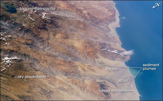
Following the last major upheaval of the Andes Mountains, rivers flowing down into the Pacific Ocean have carved dramatic canyons along Peru’s southern coast. In geologic terms, the canyons are relatively young—carved over the past 8 million years. This oblique (off-vertical) image from March 14, 2003, provides a southward look down Peru’s rugged, arid coastline between 15.5 and 17 degrees South latitude. The canyons run from left to right and appear grayer than the surrounding reddish-brown terrain.
The canyons found here are some of the deepest and steepest on Earth—lake Laguna Parincocha (top left corner) lies on the Andean plateau about 3,250 meters (10,700 feet) above sea level, about 80 kilometers (50 miles) from the coast. At lower left, a dense pattern of parallel grooves has been carved into a sheet of volcanic rock by now-dry streams. The volcanic rock is a kind called ignimbrite, which is the result of an eruption of hot gases and small rock fragments that flow from the volcano like a fluid (a pyroclastic flow). In an ignimbrite, the rock fragments are mostly pumice, a lightweight volcanic glass full of cavities.
The Yauca and Acarí rivers feed small, tan-colored sediment plumes into the sea (lower right). Dark green agricultural fields cluster along the lower courses of the rivers. Strong southerly winds have generated sand dunes and dark wind streaks along the coast, whose alignments re-curve inland into the lower river valleys (lower right). The coast and canyons are commonly hazy due to oceanic air and blowing dust. Yellow lines parallel with the coast and near the small peninsula are raised shorelines probably caused by tectonic uplift of the coastline.
References & Resources
Astronaut photograph ISS006-E-38306 was acquired March 14, 2003 with a Kodak 760C digital camera with a 180 mm lens, and is provided by the ISS Crew Earth Observations experiment and the Image Science & Analysis Group, Johnson Space Center. The International Space Station Program supports the laboratory to help astronauts take pictures of Earth that will be of the greatest value to scientists and the public, and to make those images freely available on the Internet. Additional images taken by astronauts and cosmonauts can be viewed at the NASA/JSC Gateway to Astronaut Photography of Earth.


