


August 26, 2020
August Fires Leave Vast Burn Scars in California
After more than a week, the seemingly relentless wildfires across Northern California appeared to be waning and better controlled thanks to lighter winds, lower air temperatures, and some extra firefighting assistance to aid California’s crews. Nonetheless, the fires have left extensive scars on the landscape.
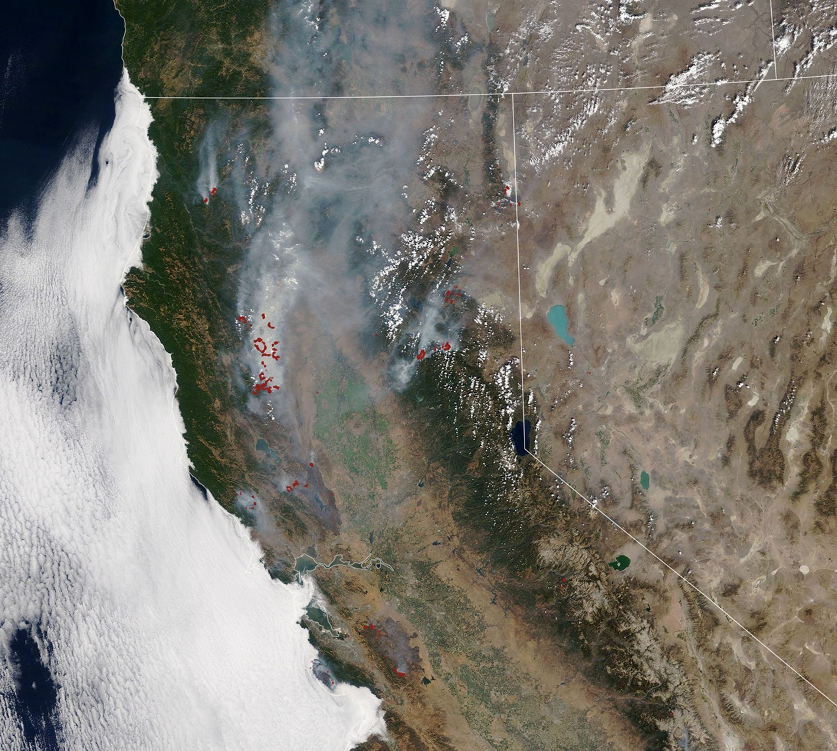
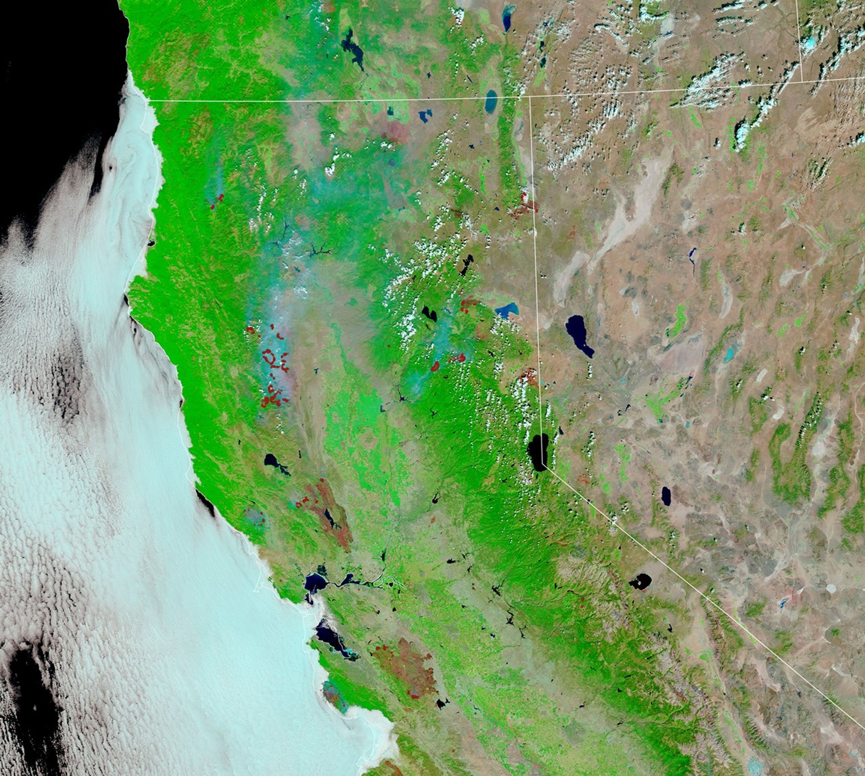
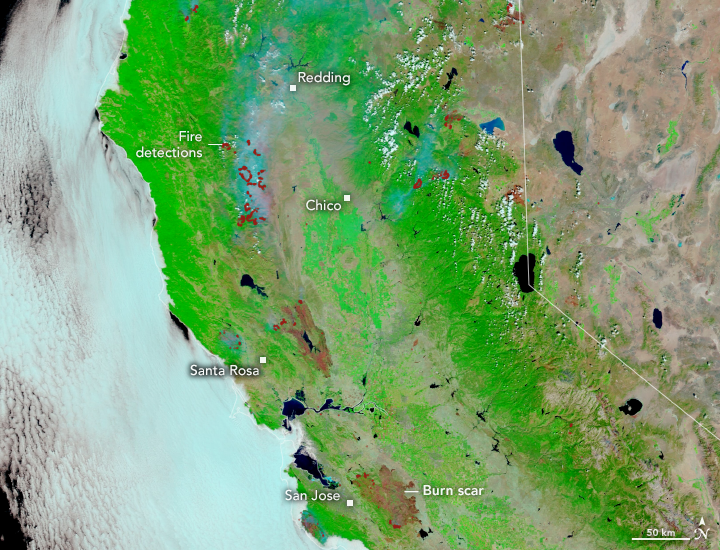
The images above show burn scars from the two largest blazes in what fire managers are calling the August Lightning Siege of 2020, when lightning strikes ignited hundreds of wildfires across Northern California. The images were acquired on August 26 by the Moderate Resolution Imaging Spectroradiometer (MODIS) on NASA’s Terra satellite. Red marks depict “fire detections,” or pixels in which the sensor and a computer algorithm indicated there was active fire. The false-color image uses a combination of visible and infrared light (MODIS bands 7,2,1) to better show the burn scars through the smoke. Burned vegetation appears brown and unburned vegetation appears bright green.
Since August 17, 2020, wildfires have burned through more than 1 million acres (4,000 square kilometers), destroyed around 2,000 structures, and caused at least seven deaths. The LNU Lightning Complex near Santa Rosa and the SCU Lightning Complex near San Jose had each burned more than 360,000 acres (140,000 square kilometers) as of August 27—making them the second and third largest fires by acreage in state history. Both fires were about 33 percent contained.
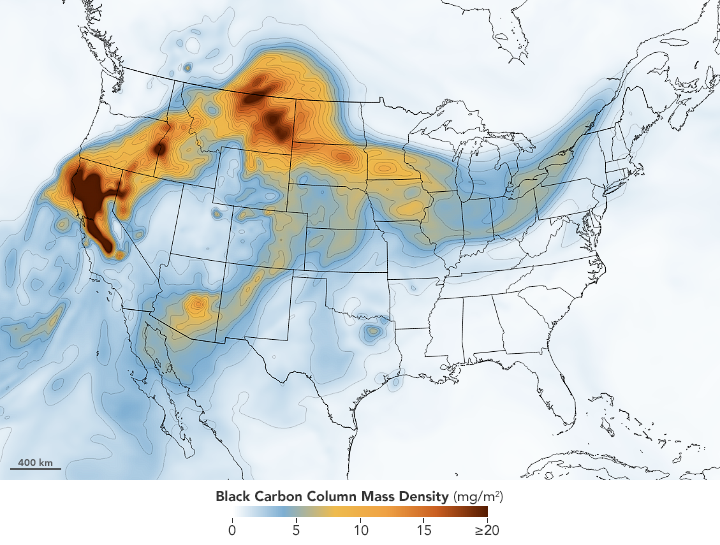
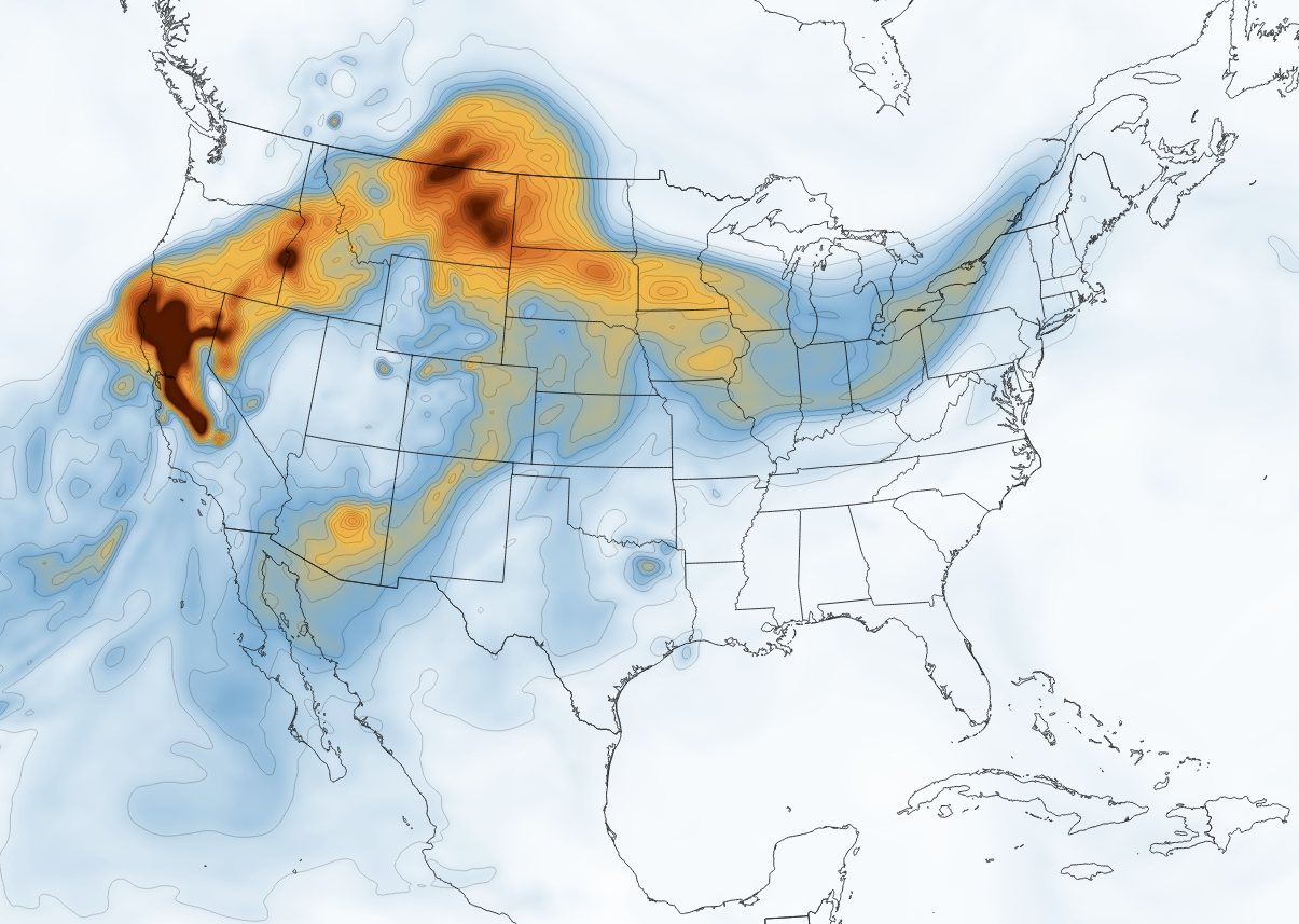
Wildfire smoke has significantly degraded air quality across Northern California and is spreading toward central and eastern parts of North America. Citizens reported hazy skies in North Dakota, Indiana, and even Virginia. Wildfire smoke is particularly harmful because it contains fine particulate matter that can cause breathing and lung problems, particularly for people with asthma.
The map above shows the concentration of black carbon particulates—commonly called soot—on August 25. Black carbon can harm humans and other animals by entering the lungs and bloodstream; it also plays a role in global warming. The black carbon map comes from the GEOS forward processing (GEOS-FP) model, which assimilates data from satellite, aircraft, and ground-based observing systems. In this case, GEOS-FP assimilated fire and aerosol observations with meteorological data on air temperature, moisture, and winds to project the behavior and extent of the plume.
References & Resources
- California Department of Forestry and Fire Protection (2020) August Lightning Siege of 2020. Accessed August 27, 2020.
- CNBC (2020, August 24) Crews keep working to pen in huge California wildfires. Accessed August 27, 2020.
- CNN (2020, August 25) California wildfires have burned 1.25 million acres, but firefighters say the weather is now helping. Accessed August 27, 2020.
- The Mercury News (2020, August 27) Bay Area wildfire updates: LNU Complex overtakes SCU Complex, now No. 2 in California history. Accessed August 27, 2020.
- NASA Earth Observatory (2020, August 21) Wildfire Smoke Shrouds the U.S. West.
- The Sacramento Bee (2020, August 26) Here are Californiaâs biggest fires burning right now, and where air quality is worst. Accessed August 27, 2020.
- The San Francisco Chronicle (2020, August 23) LNU, SCU wildfires skyrocket into top 3 largest in California history: See Cal Fire list. Accessed August 27, 2020.
- WDBJ (2020, August 25) Smoke from the California wildfires has made its way to the east coast. Accessed August 27, 2020.
NASA Earth Observatory images by Lauren Dauphin and Joshua Stevens, using MODIS data from NASA EOSDIS/LANCE and GIBS/Worldview and GEOS-5 data from the Global Modeling and Assimilation Office at NASA GSFC. Story by Kasha Patel .