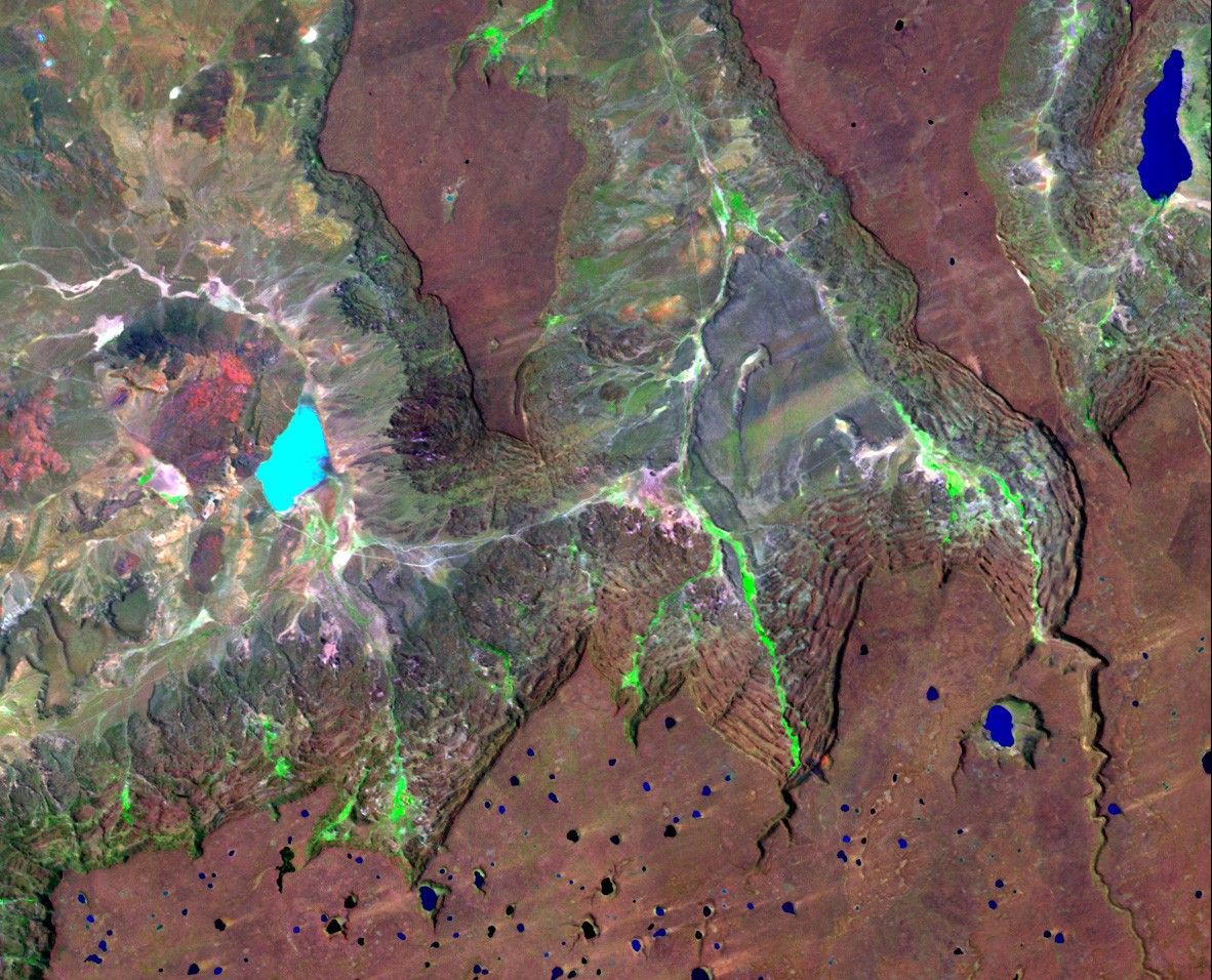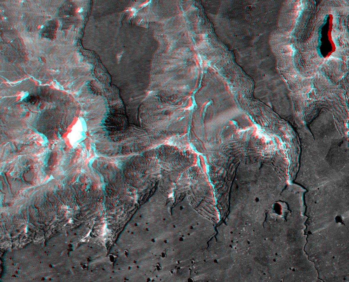
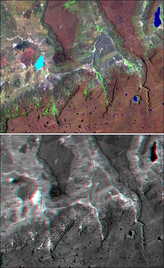
Basalt cliffs along the northwest edge of the Meseta de Somuncuraplateau near Sierra Colorada, Argentina show an unusual and strikingpattern of erosion. Stereoscopic observation helps to clarify thelandform changing processes active here. Many of the cliffs appear to berock staircases that have the same color as the plateau's basalticcaprock. Are these the edges of lower layers in the basalt, or are they atrain of slivers that are breaking off from, then sliding downslope andaway from, the caprock? They appear to be the latter. Close inspectionshows that each stair step is too laterally irregular to be a continuoussheet of bedrock like the caprock. Also, the steps are not flat butinstead are little ridges, as one might expect from broken, tilted, andsliding slices of the caprock. Stream erosion has cut some gullies intothe cliffs and green vegetation shows that water springs from and flowsdown some channels, but landsliding is clearly a major agent of erosionhere.
Landsat satellites have provided visible light and infrared images ofthe Earth continuously since 1972. SRTM topographic data match the30-meter (99-foot) spatial resolution of most Landsat images and providea valuable complement for studying the historic and growing Landsat dataarchive. The Landsat 7 Thematic Mapper image used here (top image) was provided tothe SRTM project by the United States Geological Survey, Earth ResourcesObservation Systems (EROS) Data Center, Sioux Falls, South Dakota.
This anaglyph (lower image) was generated by first draping a Landsat Thematic Mapperimage over a topographic map from the Shuttle Radar Topography Mission,then producing the two differing perspectives, one for each eye. Whenviewed through special glasses, the result is a vertically exaggeratedview of the Earth's surface in its full three dimensions. Anaglyphglasses cover the left eye with a red filter and the right eye with ablue filter.
Elevation data used in the lower image was acquired by the Shuttle RadarTopography Mission (SRTM) aboard the Space Shuttle Endeavour, launchedon February 11, 2000. SRTM used the same radar instrument that comprisedthe Spaceborne Imaging Radar-C/X-Band Synthetic Aperture Radar(SIR-C/X-SAR) that flew twice on the Space Shuttle Endeavour in 1994.SRTM was designed to collect three-dimensional measurements of theEarth's surface. To collect the 3-D data, engineers added a60-meter-long (200-foot) mast, installed additional C-band and X-bandantennas, and improved tracking and navigation devices. The mission is acooperative project between the National Aeronautics and SpaceAdministration (NASA), the National Imagery and Mapping Agency (NIMA) ofthe U.S. Department of Defense (DoD), and the German and Italian spaceagencies. It is managed by NASA's Jet Propulsion Laboratory, Pasadena,CA, for NASA's Earth Science Enterprise, Washington, DC.
Size: 49 kilometers (30 miles) x 29 kilometers (18 miles)
Location: 41 deg. South lat., 67.4 deg. West lon.
Orientation: North toward upper left
Image Data: Landsat bands 1,4,7 (blue, near infrared, short wave infrared) in blue, green, red
Date Acquired: February 19, 2000 (SRTM), January 22, 2000 (Landsat)
For more information, visit the SRTMsite and the Landsat 7 site.
References & Resources
Images courtesy NASA/JPL/NIMA