


December 25, 2022
A powerful Arctic cold front battered the Midwest and eastern U.S. in late-December 2022. The storm brought blizzard conditions to some areas, life-threatening cold to others, and daunting amounts of lake-effect snow. As winds howled and snow piled up from what some forecasters called a “once-in-a-generation” storm, so did the traffic accidents, power outages, and transportation woes.
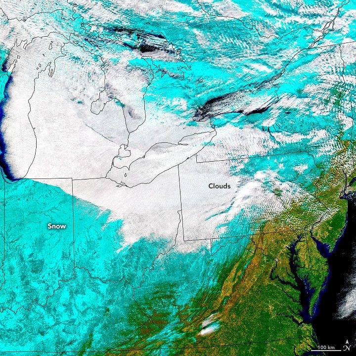
These images show the snow- and cloud-covered northeastern states as observed on December 25, 2022, by the Moderate Resolution Imaging Spectroradiometer (MODIS) on NASA’s Aqua satellite. Cloud streets over Lake Michigan hint at the powerful winds that accompanied the deadly storm. Gusts surged as high as 79 miles (127 kilometers) per hour in Lackawanna, New York. In several other states, winds topped 50 miles per hour, according to data from the National Weather Service.
The bands of clouds streaming off the lakes, which form when cold air passes over open water, can produce lake-effect snow. While snowfall totals generally stayed below 5 inches (13 centimeters) in most areas touched by the storm, lake-effect snow caused totals to surge above 50 inches in communities east of Lake Ontario and Lake Erie in upstate New York—including Buffalo. In these areas, early winter storms are known for producing huge amounts of snow because the lakes often have not frozen over yet.
The first image is natural color, while the second uses a combination of visible and shortwave infrared light (bands 7-2-1) to distinguish clouds (white) from snow and ice (blue). The ripple pattern in the clouds was likely caused by the presence of wave clouds. Wave clouds typically form when air gets forced upward by hills and mountains, in this case, the Appalachians. When gravity causes the air to fall back down, it begins to oscillate, creating the waves. Clouds generally form on the cool crests of waves when there is enough moisture in the air.
References & Resources
- AccuWeather (2022, December 23) Death toll rises in wake of Buffalo blizzard, unrelenting bomb cyclone. Accessed December 27, 2022.
- Associated Press (2022, December 27) Winter weather upends water systems across the Deep South. Accessed December 27, 2022.
- The Buffalo News (2022, December 27) Complete coverage: WNY continues to dig out following blizzard . Accessed December 27, 2022.
- NASA MODIS and VIIRS Snow and Ice Global Mapping Project. Accessed December 29, 2022.
- NASA Earth Science Data Systems (ESDS) Snow/Ice. Accessed December 27, 2022.
- National Weather Service Buffalo (2022, December 27) 4 Day Storm Snowfall Reports. Accessed December 27, 2022.
- National Weather Service Chicago (2022) December 22-23, 2022: Powerful Arctic Front Brings Snow, Strong Winds, and Bitterly Cold Temperatures to the Region. Accessed December 27, 2022.
- Rutgers University (2022) Global Snow Lab. Accessed December 29, 2022.
- The Washington Post (2022, December 23) How the size and depth of the Great Lakes affect how much snow falls. Accessed December 27, 2022.
- USA Today (2022, December 27) Fierce winter storm still taking a toll: 28 dead; thousands without power; flight cancellations mount. Accessed December 27, 2022.
NASA Earth Observatory images by Joshua Stevens , using MODIS data from NASA EOSDIS LANCE and GIBS/Worldview . Story by Adam Voiland .


