


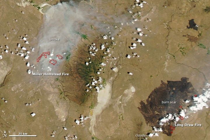
On July 11, high temperatures and strong winds fueled brush fires in eastern Oregon. The Long Draw Fire, located ten miles (16 kilometers) west of Basque, was discovered on July 8, 2012, after a lightning strike. By the morning of July 12, the fire was 30 percent contained, but it had charred 455,029 acres (1,841 square kilometers) of short grass and sagebrush. The Miller Homestead fire, about 60 miles to the northwest, started on the same day and had burned 60,000 acres by July 12.
The Moderate Resolution Imaging Spectroradiometer (MODIS) on NASA’s Aqua satellite captured this image of the fires on July 11, 2012. Red outlines indicate hot spots where MODIS detected unusually warm surface temperatures associated with fires. Land surfaces covered by dry vegetation is tan. Green areas are irrigated or near bodies of water. The Long Draw fire's burn scar is gray. Clouds obscure most of the smoke from Long Draw fire, but a large cloud of smoke is visible north of the Miller Homestead fire.
Further Reading
- Associated Press. (2012, July 12). E. Oregon Wildfires Grow; Frenchglen Put on Alert. Accessed July 12, 2012.
References & Resources
- Inciweb. (2012, July 12). Miller Homestead Fire. Accessed July 12, 2012.
- Inciweb. (2012, July 12). Long Draw Fire. Accessed July 12, 2012.
NASA image courtesy Jeff Schmaltz, LANCE MODIS Rapid Response. Caption by Adam Voiland.


