


About 8 percent of Earth’s skies are covered by mixed-phase midlevel stratiform clouds such as altocumulus and altostratus—formations that generally appear horizontal and layered.
Occasionally, especially near airports in the winter, the bottom of these clouds will fall out, creating a peculiar formation called cavum, which are also called hole-punch clouds and fallstreak holes. This image, captured by the OLI-2 (Operational Land Imager-2) on Landsat 9, shows a pair of cavum in a cloud layer over Wichita, Kansas, on December 2, 2024.
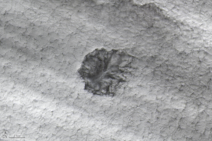
From below (and above), cavum look like a circle or ellipse has been cut neatly from the clouds. With feathery wisps left lingering in the middle, it appears as if the cloud is falling out of the sky.
The phenomenon occurs in mid-level clouds containing supercooled water droplets, which remain liquid even below the typical freezing point of water (32 degrees Fahrenheit or 0 degrees Celsius). But even supercooled droplets can eventually freeze.
As an airplane passes through the cloud layer, additional cooling occurs over the wings of the aircraft and can push supercooled liquid droplets to freeze. Ice crystals beget more ice crystals, and they eventually grow heavy and fall, leaving a void in the cloud. The falling ice crystals often appear as wispy trails of precipitation, called virga.
Researchers looking at major airports around the world estimate that atmospheric conditions are right for cavum formation about 3 to 5 percent of the time overall but 10 to 15 percent of the time in the winter.
Planes passing at sharp angles produce small, circular cavum. At shallow angles, planes create long “canal clouds” with extended virga trails. Other factors that affect the length of cavum include the thickness of the cloud layer, the air temperature, and the degree of wind shear.
Every day, an average of 34 flights take off from Wichita Dwight D. Eisenhower National Airport.
References & Resources
- EarthSky (2023, May 14) What are hole-punch clouds, aka fallstreak holes? Accessed December 16, 2024.
- Heymsfield, A., et al. (2010) Aircraft-Induced Hole Punch and Canal Clouds: Inadvertent Cloud Seeding. Bulletin of the American Meteorological Society, 91 (6), 753-766.
- Heymsfield, A., et al. (2011) Formation and Spread of Aircraft-Induced Holes in Clouds. Science, 333 (6038), 77-81.
- Korolev, A., et al. (2017) Mixed-Phase Clouds: Progress and Challenges. Meteorological Monographs, 5.1-5.5.
- Lyons, W. (2020) How to Make a Cloud. Weatherwise, 74(1), 24-31.
- NASA Earth Observatory (2014) Supercool Clouds. Accessed December 16, 2024.
NASA Earth Observatory images by Michala Garrison, using Landsat data from the U.S. Geological Survey . Story by Adam Voiland .


