


Science in Action
NASA satellites and sensors constantly take the pulse of our planet, measuring how Earth changes by the day, season, year, and decade. Researchers and resource managers analyze those measurements and apply them on local and regional scales to better manage things like our food and water supplies, health, safety, land use, and ecosystems. NASA data is also used by other government agencies to help with responses to natural disasters and emergencies around the country and the world.
An Earth Observatory Collection

Scientists say the seasonal crop fires are burning later in the day than in previous years.

As wildland fires raged in the American West, NASA airborne technology was there to image it in incredible detail.

Data provided by the water satellite are helping to improve tsunami forecast models.
That’s a key question for many farmers, and new research may make it easier to develop growing season plans.

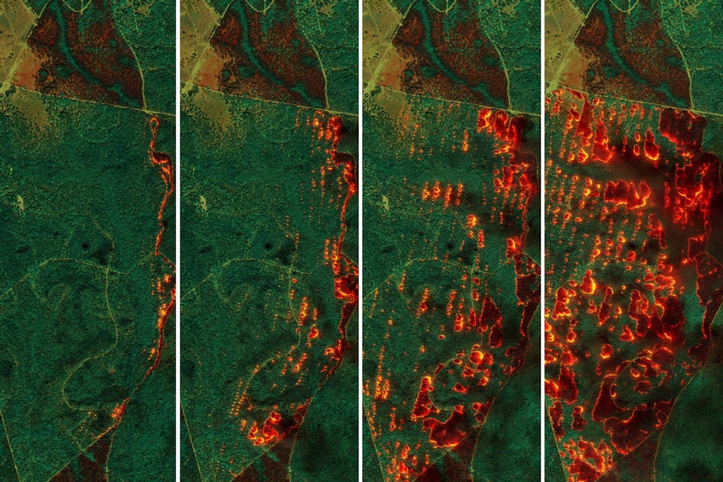
NASA airborne technology revealed the progression of a controlled fire at Fort Stewart-Hunter Army Airfield.
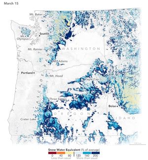
A warm and dry spring in the Pacific Northwest quickly depleted the seasonal snowpack, raising concern over summer water supplies…

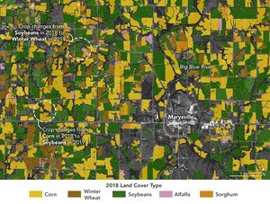
Scientists used Landsat satellite images to detect both abrupt and gradual changes and to examine how phenomena, from storms to…

Researchers used NASA satellite data to detect swarms of red-tinged copepods, a key food source for the endangered marine mammals,…

Satellite-derived maps of nighttime lights in southern Spain revealed power outages that persisted across rural areas as the region was…

Detailed fire maps, produced in minutes with data from a NASA airborne sensor, enabled firefighters in Alabama to limit the…

Depictions of the seafloor derived from satellite data can improve underwater navigation and increase knowledge of how heat and life…
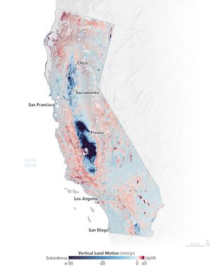
The elevation changes may seem small, amounting to fractions of inches per year, but they can increase or decrease local…

NASA radar imagery revealed that the active area of a decades-old landslide has grown following periods of heavy rainfall in…

The buildup of vegetation and a rapid shift from wet to dry conditions played a role in the destructive blazes.

A series of images captured by NASA’s TEMPO sensor show the shifting location of nitrogen dioxide as destructive fires raged…

A NASA airborne instrument captured images of the fire’s aftermath in and around Altadena.

Two decades of satellite data show that the most destructive U.S. fires burn in grasslands and shrublands fanned by strong…

Satellite observations at night indicate that oil, gas, and mining have expanded across Earth’s northern latitudes.

The iconic trees and shrubs of the Florida Everglades are under increased stress due to more frequent, intense hurricanes.
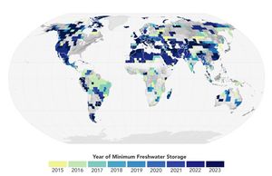
The amount of freshwater stored on land and underground has plummeted in the past decade, which might indicate that Earth’s…

Rising seas have redistributed cyanobacterial mats blanketing part of Andros Island and restructured the island’s marshes and mudflats.


