


Ivy first formed into a tropical storm at 18Z on the 22nd of February2004 midway between Fiji to the east and Vanuatu to the west. Thestorm moved northwest for a day and gained strength becoming a minimalCategory 1 cyclone at 18Z on the 23rd. Ivy then recurved toward thesouthwest on the 24th and continued to intensify threatening theVanuatu islands. By 06Z on the 25th Ivy was bearing down on the islandof Malakula in central Vanuatu with maximum sustained winds estimatednear 90 knots (104 mph) by the Joint Typhoon Warning Center.
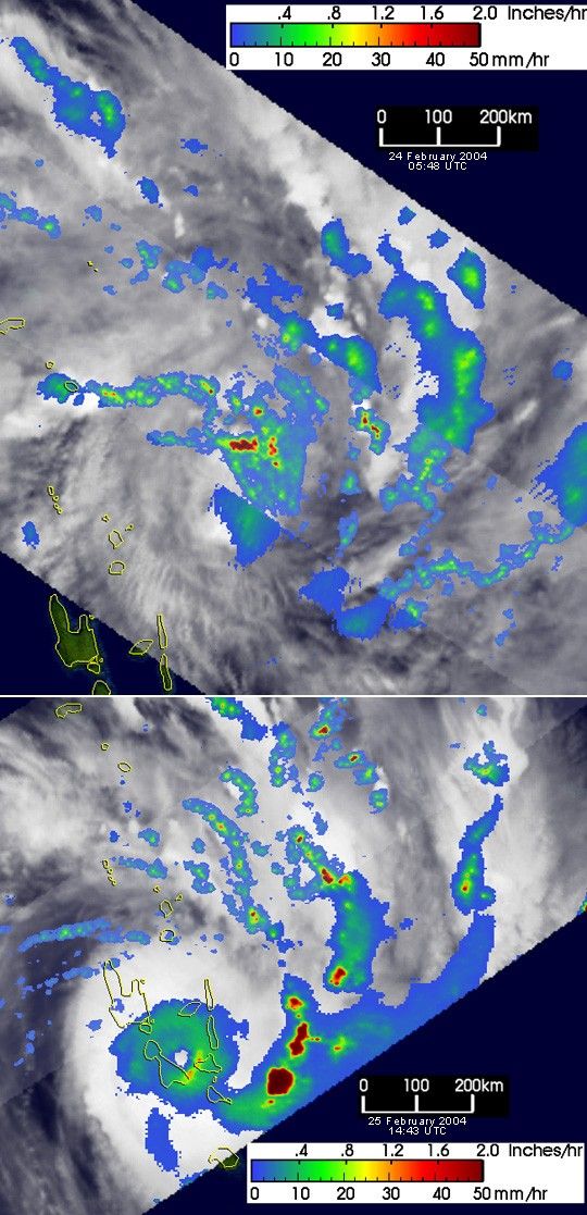
The Tropical Rainfall Measuring Mission (TRMM) satellite captured theseunique images of Cyclone Ivy as it approached Vanuatu. The top imagewas taken at 05:48 UTC on 24 February 2004. It shows the horizontaldistribution of rain rates observed by the TRMM Precipitation Radar (PR)in the center swath and the TRMM Microwave Imager (TMI) in the outerswath. The rain rates are overlaid on infrared (IR) data from the TRMMVisible Infrared Scanner (VIRS). At this time, Ivy was estimated to havesustained winds of 70 knots (83 mph). TRMM shows that Ivy is still inthe process of organizing with no clear eye present yet. However, asubstantial area of intense rainfall (darker reds) is detected near thecenter of the circulation. As hurricanes depend on the heat releasedfrom the condensation of water vapor to fuel their circulation, thepresence of these rainrates near the center of the storm where they arethe most effective, indicates the potential for further strengthening.
The bottom image shows Ivy almost a day and half later at 14:33 UTC on the25th just before hitting the island of Malakula. The winds are now up to90 knots (104 mph), and TRMM shows that Ivy now has a well-developed,symmetrical eye that is associated with mature tropical cyclones. Theeye is surrounded by mainly moderate rainrates (green areas) with themost intense rainrates (dark reds) present in rainbands off to the east.
TRMM is a joint mission between NASA and the Japanese space agency JAXA.
References & Resources
Images produced by Hal Pierce (SSAI/NASA GSFC) and caption by Steve Lang (SSAI/NASA GSFC).


