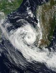

Cyclone Izilda had estimated winds of 65 kilometers per hour (40 miles per hour or 35 knots) at roughly the same time that the Moderate Resolution Imaging Spectroradiometer (MODIS) on NASA’s Terra satellite captured this image on March 25, 2009. The storm intensified the following day, and the Joint Typhoon Warning estimated that Izilda had sustained winds of 101 kilometers per hour (63 miles per hour or 55 knots) and gusts up to 130 kilometers per hour (81 miles per hour or 70 knots) on March 26.
Most of the clouds in this photo-like image from March 25 are concentrated in Cyclone Izilda, leaving a relatively clear view of southern Madagascar. A line of dark green mountains runs up the eastern side of the island. To the east, the land is lush and green. Inland, to the west of the mountains, the land is drier and brown.
The high-resolution image provided above is at MODIS’ full spatial resolution (level of detail) of 250 meters per pixel. The MODIS Rapid Response System provides this image at additional resolutions.
References & Resources
NASA image by Jeff Schmaltz, MODIS Rapid Response Team, Goddard Space Flight Center. Caption by Holli Riebeek.